
Looks like it's on the northeast side of Cogswell Reservoir not far from the dam:
http://hpwren.ucsd.edu/cameras/I/wilson-e-mobo-c.html
Bobcat Fire in West Fork
-
walker

- Posts: 248
- Joined: Mon Apr 08, 2013 11:14 pm
You do not have the required permissions to view the files attached to this post.
-
walker
- Posts: 248
- Joined: Mon Apr 08, 2013 11:14 pm
If I'm not mistaken, seems to be ascending Glenn Canyon towards Monrovia Peak as well.
For reference, I think the lower part of Cogswell-Rincon-RedBox connector road is visible sloping upwards just right of the dam - looks like the smoke is coming out of the canyons behind that ridge.
For reference, I think the lower part of Cogswell-Rincon-RedBox connector road is visible sloping upwards just right of the dam - looks like the smoke is coming out of the canyons behind that ridge.
You do not have the required permissions to view the files attached to this post.
-
stonehillnews
- Posts: 85
- Joined: Thu Dec 15, 2016 1:31 pm
Dima and I happened to be up near Little Jimmy today.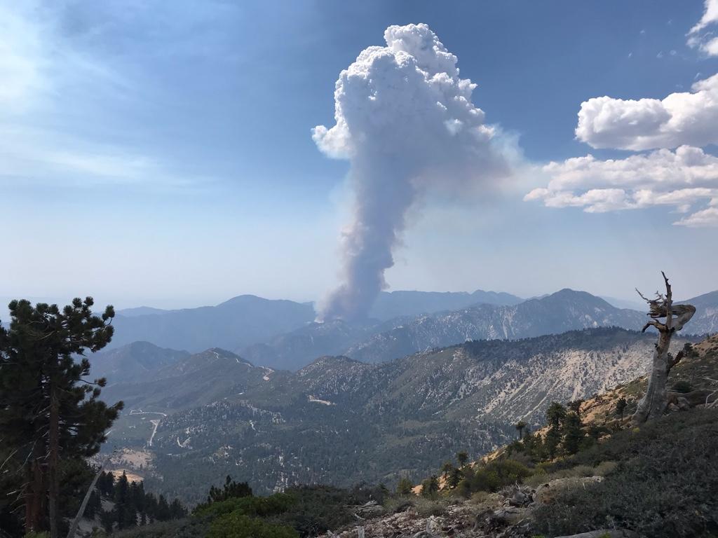
This photo was taken at 12:57
This photo was taken at 12:57
-
stonehillnews
- Posts: 85
- Joined: Thu Dec 15, 2016 1:31 pm
We got turned back on ACH at 4:28. We decided to stop for food in Wrightwood instead. We’re here now.
-
Sean

- Cucamonga
- Posts: 4415
- Joined: Wed Jul 27, 2011 12:32 pm
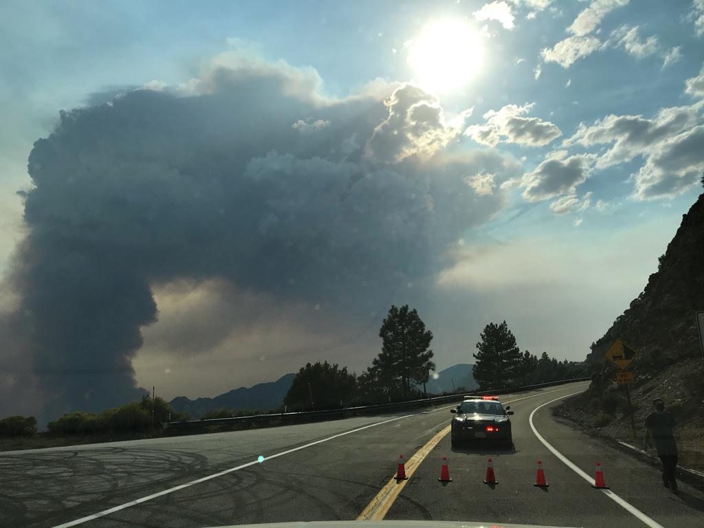
The plume seen from Temple City. It's dropping ash on my parents' house.
You do not have the required permissions to view the files attached to this post.

-
walker
- Posts: 248
- Joined: Mon Apr 08, 2013 11:14 pm
You can follow the progress in the archive of towercam images.
In the afternoon it split into a north and south front:
Then around sundown the flames started to show themselves:
And then it started to look more like the crack of doom:
And now it looks like something out of Hieronymous Bosch - The next time anybody tries to go to the Mermaids, it should be somewhat less brushy...
You do not have the required permissions to view the files attached to this post.

-
dima

- Posts: 1930
- Joined: Wed Feb 12, 2014 1:35 am
- Location: Los Angeles
map:
https://caltopo.com/map.html#ll=34.2369 ... a=modis_mp
It advanced North quite a bit last night. Looks like Mermaid ridge is passable now indeed. And since I checked this morning the South front advanced a LOT. White Saddle has burned, or is about to. Taco WILL be able to hike all of Silver-Fish road!
-
Sean
- Cucamonga
- Posts: 4415
- Joined: Wed Jul 27, 2011 12:32 pm
No official map yet, but it's approaching 5000 acres in size with zero containment.
https://inciweb.nwcg.gov/incident/7152/
Screenshot from Dima's link:
https://inciweb.nwcg.gov/incident/7152/
Screenshot from Dima's link:
You do not have the required permissions to view the files attached to this post.
-
AW~

- Posts: 2124
- Joined: Mon Oct 01, 2007 12:00 pm
Probably another Station part 2 at this rate.
Granted there was 2,000+ assigned at part 1, but 100 should do it this time lol...total joke alll the way around.
Granted there was 2,000+ assigned at part 1, but 100 should do it this time lol...total joke alll the way around.
-
AW~
- Posts: 2124
- Joined: Mon Oct 01, 2007 12:00 pm
I can say for sure that a fire is actually good for the area being burned...a clear indictment of our fire policy.Girl Hiker wrote: Saddened by the fire but great shots!
Now of course, it will be greater than SG wilderness, but who cares? The state wants it all burned.
Also,I feel for the residents, but this particular problem of Monrovia has been known for ages.
But there is pipelines they said, so no pre-burns...well, OK then.
I have spent a number of times at the Pasadena club steps resting of travels...its sad, such a nifty historical place.
Mr.Wetherby and his associated friends are such hospitable people. I hope somehow the cabin made it, but I noticed 2 hot spots right on it.
-
walker
- Posts: 248
- Joined: Mon Apr 08, 2013 11:14 pm
On inciweb what do the yellow vs. red marks mean?
At this point, Big Santa Anita Canyon and Monrovia Canyon could be in jeopardy.
Didn't burn in Station Fire, so plenty of fuel.
At this point, Big Santa Anita Canyon and Monrovia Canyon could be in jeopardy.
Didn't burn in Station Fire, so plenty of fuel.
-
walker
- Posts: 248
- Joined: Mon Apr 08, 2013 11:14 pm
Sorry, I meant the caltopo map, not inciweb.
-
ReFreshing

- Posts: 68
- Joined: Mon Nov 26, 2018 1:00 pm
Just saw the flames cresting monrovia peak as I drove by about an hour ago... ?walker wrote: If I'm not mistaken, seems to be ascending Glenn Canyon towards Monrovia Peak as well.
For reference, I think the lower part of Cogswell-Rincon-RedBox connector road is visible sloping upwards just right of the dam - looks like the smoke is coming out of the canyons behind that ridge.
BobcatFire2.jpg
-
patrick

- Posts: 33
- Joined: Sat Aug 15, 2020 5:24 pm
man, that's sad... camped for a few days in Devil's Canyon near where it meets the reservoir ~6 weeks ago, a really cool area, tons of wildlife. There are a few buildings by the dam, which according to that caltopo map must be gone by now. Looks like it's only 3-4 miles from the eastern edge of the Station fire now.
-
patrick
- Posts: 33
- Joined: Sat Aug 15, 2020 5:24 pm
Just saw the whole forest (and a bunch of others) are closed for the next week — https://www.fs.usda.gov/detail/ltbmu/ne ... EPRD799171
-
ReFreshing
- Posts: 68
- Joined: Mon Nov 26, 2018 1:00 pm
Sucks but I think it's the right call to make right now.patrick wrote: Just saw the whole forest (and a bunch of others) are closed for the next week — https://www.fs.usda.gov/detail/ltbmu/ne ... EPRD799171
-
Sean
- Cucamonga
- Posts: 4415
- Joined: Wed Jul 27, 2011 12:32 pm
We can see the flames now from across the valley in Alhambra.ReFreshing wrote: Just saw the flames cresting monrovia peak as I drove by about an hour ago... ?
You do not have the required permissions to view the files attached to this post.
-
walker
- Posts: 248
- Joined: Mon Apr 08, 2013 11:14 pm
Another valley of fire hellscape tonight:
The fishing club cabin is probably a gonner for sure - looks like Clamshell or Rankin is keeping it to the east for now...
The fishing club cabin is probably a gonner for sure - looks like Clamshell or Rankin is keeping it to the east for now...
You do not have the required permissions to view the files attached to this post.
-
dima
- Posts: 1930
- Joined: Wed Feb 12, 2014 1:35 am
- Location: Los Angeles
I was looking up from Arcadia earlier as the fire came over Monrovia peak. There were two bulldozers clearing (or maybe re-clearing) lines near Clamshell peak.
-
maxmapper
- Posts: 56
- Joined: Fri Jan 17, 2020 5:50 pm
RIP that one weed grow south of Twin Peaks
You do not have the required permissions to view the files attached to this post.
-
walker
- Posts: 248
- Joined: Mon Apr 08, 2013 11:14 pm
And the various ones in the canyons just north of Twin Peaks.RIP that one weed grow south of Twin Peaks
-
dima
- Posts: 1930
- Joined: Wed Feb 12, 2014 1:35 am
- Location: Los Angeles
Imagine what it's like to be the farmers. I guess they're walking out to the desert? Nobody's picking them up anywhere else.
-
walker
- Posts: 248
- Joined: Mon Apr 08, 2013 11:14 pm
What a difference a day makes. Cooler temps seem to have slowed it down a lot:
You do not have the required permissions to view the files attached to this post.
-
AW~
- Posts: 2124
- Joined: Mon Oct 01, 2007 12:00 pm
...the left of your picture I think is mostly a big plume of smoke out of the south. The fire is moving towards Wilson right now also(and fast)walker wrote: What a difference a day makes. Cooler temps seem to have slowed it down a lot:
Bobcat200.jpg
Twitter shows the fire creeping down to Monrovia....had to do a double take. The winds have getting stronger for an hour and it looks like its going into the East Fork too.
I imagine all the fire force is cursing it now.
-
walker
- Posts: 248
- Joined: Mon Apr 08, 2013 11:14 pm
I stand corrected, embers picking back up with a reflective glow in the sky towards the left/north side and spots visibly further down Monrovia ridge to the right/south - it's like a bomb went off.
You do not have the required permissions to view the files attached to this post.
-
Taco

- Snownado survivor
- Posts: 6218
- Joined: Thu Sep 27, 2007 4:35 pm
My mountains.  I’m sorry.
Yeah, silverfish Truck Trail is likely easy to hike now. I rode partway up the road the other week to see what’s up, and teams cleared the road to the firebreak, where they hiked up. Once things calm down, I may hike the whole thing with my bike.
I’m real bummed about everything. I’m gonna distract myself now. Good luck, guys.
-
Sean
- Cucamonga
- Posts: 4415
- Joined: Wed Jul 27, 2011 12:32 pm
Looks like it's crossing the ridge into Santa Anita Canyon.