
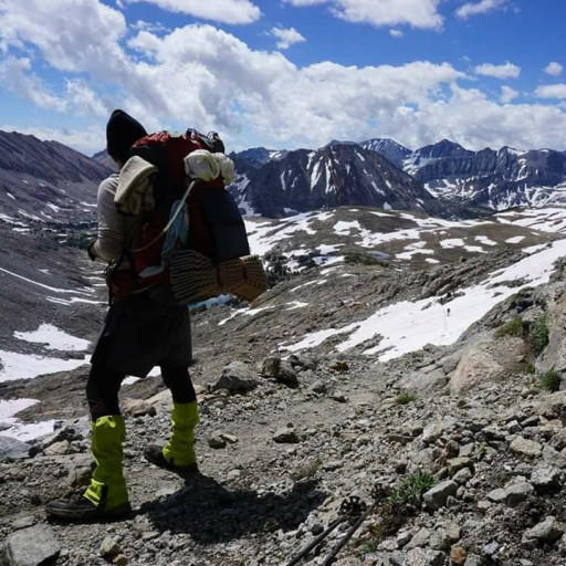
Had an awesome, overnight backpacking trip through the Angeles National Forest the last couple days. Over 20 miles & 6,000+ ft of elevation gain.
It was my first trip since returning from the PCT in October. I forgot how hard walking up a mountain with a 25lb pack on is. After my first couple hours of hiking I only saw 3 or 4 people over the next 24 hours. I had the entire campground to myself, fire pits & all. It was awesome. Surprisingly strong flowing streams given there hasn't been rain in the area in over a week and there's only patches of snow around 5,000ft., just below where that ridgeline tops out. Great time to go backcountry camping.
There are quite a few blowdowns on Upper Winter Creek Trail the closer to the saddle you are. Same goes for Mt. Wilson Toll Road going by Mount Harvard & Yale.
Route:
From Bailey Canyon to Jones Peak & onto Hoegee's Campground for the night. Then onto Mount Harvard, Mount Yale down to Henniger Flats and back out to civilization via the Walnut Creek Trail in Eaton Canyon.
Bailey Canyon > Jones Peak > Wilson Connector Trail > Upper Winter Creek Trail > Hoegee's Trail Camp (overnight) & More
-
AnthonyEKing
- Posts: 24
- Joined: Mon Mar 25, 2019 3:45 pm
You do not have the required permissions to view the files attached to this post.
-
AnthonyEKing
- Posts: 24
- Joined: Mon Mar 25, 2019 3:45 pm
More Photos.
You do not have the required permissions to view the files attached to this post.
-
AnthonyEKing
- Posts: 24
- Joined: Mon Mar 25, 2019 3:45 pm
& more.
You do not have the required permissions to view the files attached to this post.
-
AnthonyEKing
- Posts: 24
- Joined: Mon Mar 25, 2019 3:45 pm
& the final images w/ routing.
You do not have the required permissions to view the files attached to this post.
-
JeffH

- Posts: 1368
- Joined: Sun Nov 28, 2010 7:09 am
It's definitely winter grass season, looks really green in all the pics.
I've never been to Henninger Flat, seems like I should visit. Did you filter water or use it straight from the source?
I've never been to Henninger Flat, seems like I should visit. Did you filter water or use it straight from the source?
"Argue for your limitations and sure enough they're yours".
Donald Shimoda
Donald Shimoda
-
AnthonyEKing
- Posts: 24
- Joined: Mon Mar 25, 2019 3:45 pm
Everything was looking extra healthy throughout the hike. Definitely nice to see. Henninger Flats looked great to me! I've never camped there but walking through the three levels of campsites (Lower & Upper henninger as well as Fuji Campground) they looked very well taken care of, fire pits, bear cabinets, picnic tables, trash cans, newer bathroom building & it's free to camp. I saw no one there at 3pm on Monday. I was pretty surprised. The hike to Henninger from Eaton Canyon is only a couple mile fire road walk, too. I filtered water in the backcountry, Winter Creek & another seasonal stream but didn't try water at Henninger. They had spigots which I would guess are potable (given on duty rangers & proximity to the city) but I didn't look at any signs so I could be wrong. Hoegee's Trail Camp had no spigots, only Winter Creek. I use a Sawyer Squeeze. Ice cold, great tasting & looking water regardless!JeffH wrote: It's definitely winter grass season, looks really green in all the pics.
I've never been to Henninger Flat, seems like I should visit. Did you filter water or use it straight from the source?
-
Anthony

- Posts: 332
- Joined: Mon Jun 05, 2017 11:53 am
nice route! i gotta stay at hoegee's some time -- still haven't done it.
-
tekewin

- Posts: 1385
- Joined: Thu Apr 11, 2013 5:07 pm
Looks like a fun trip. Curious how you went to Yale. It was hard for me to tell from your route images.
-
AnthonyEKing
- Posts: 24
- Joined: Mon Mar 25, 2019 3:45 pm
It definitely was! Also, here's a better view of the map and the route I took to hit Mount Harvard and Yale. There's a firebreak trail you can take that breaks off of Mount WIlson Toll Rd.tekewin wrote: Looks like a fun trip. Curious how you went to Yale. It was hard for me to tell from your route images.
The waypoint marker is the Mount Wilson Trail / Mount Wilson Toll Rd. junction just northwest of the Upper Winter Creek / Mount Wilson Toll Rd. juction in the below image.
You do not have the required permissions to view the files attached to this post.