Pallett Plane Crash Loop

TRs for the San Gabriel Mountains.
Post Reply
User avatar
tekewin
Posts: 1259
Joined: Thu Apr 11, 2013 5:07 pm

Post by tekewin »

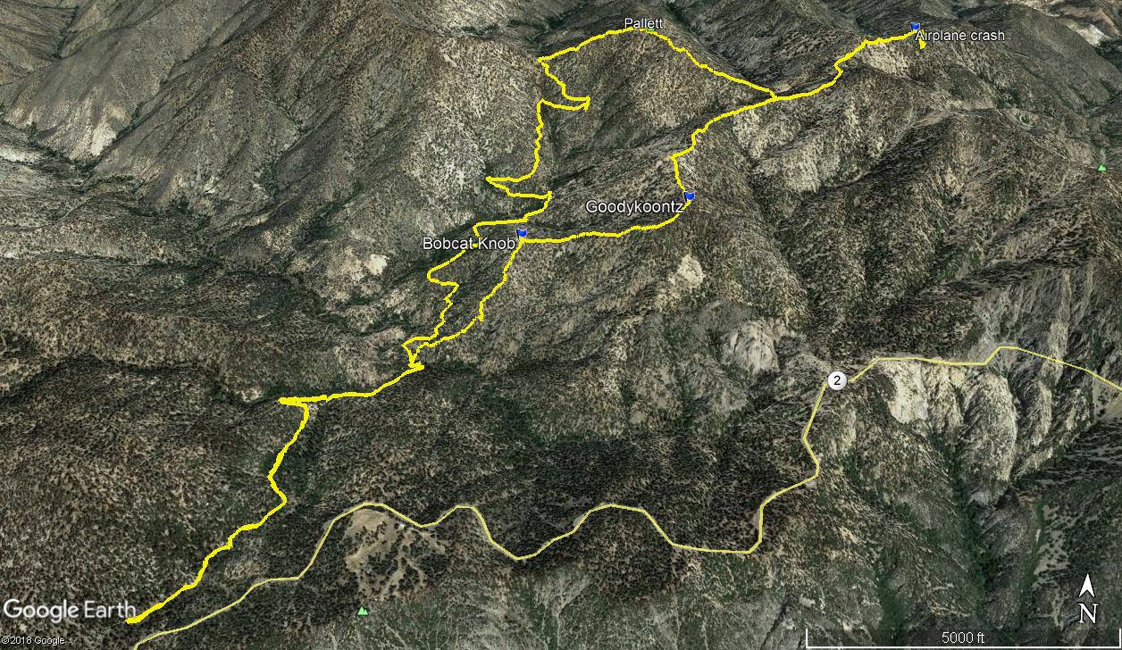
Warm weather was ideal for a high country trip in the Angeles. I planned a loop starting on the Burkhart Trail to:
  1. Bobcat Knob
  2. Goodykoontz Peak
  3. Pallett Mountain
I also had a side trip in mind to check out the C-119 Flying Boxcar crash site about a mile off the loop. The C-119 crashed in stormy weather on 9/30/1966 with 4 fatalities. It might be a shorter trip to the crash site to go over Williamson. The nicest part of the ANF (IMO) is this section of high ground along both sides of highway 2. Big pines and big cedars with little underbrush. It rivals the San Jacinto Wilderness for beauty. I took the trail to the bottom of Cooper Canyon, then went around one turn in the trail past the Burkhart/Rattlesnake junction and left the trail for the ridge to Bobcat. David R calls it Bobcat Knoll, but Peakbagger calls it Bobcat Knob. Same thing. The route after leaving the trail is all class 1, but steep. This ridge gains 1000' to Bobcat Knob and another 900' to Goodykoontz for a total of 1900' in less than a mile. A nice rock cairn marked the top of Bobcat. I took a few breaths, then plowed up to Goodykoontz. This seemed like the steepest section of the entire hike. A good use trail appeared on the ridge to Goodykoonntz and got better as I went along. I found register cans in between two small outcrops on the summit, no benchmarks. A memorial newsletter was in a separate plastic baggie inside the register. It was idyllic on the summit and I was tempted to just nap in the morning sun. But I had a lot on the itinerary, so fueled up and started down the other side in search of the C-119 plane crash.

Image

Image
Coming up on Bobcat

Image
Pallett from Bobcat

Image
Goodykoontz memorial hike, 2005

I dropped to the saddle between Goodykoontz and Williamson, then continued up toward Williamson. Along the way, I found a side use trail that headed toward the ridge with the plane crash. It was unexpected, but saved some gain and distance. The use trail continued along the south, then north side of the ridge and led right into the debris field on the north side. The C-119 apparently crashed near the top of the south ridge sending debris over the top. Most of the plane remained on the south side and large pieces have been washed down the side over time. I focused on the south side, descending about 200' down the slope. There were more parts farther down. I've read about another crash site farther down the north side, but I didn't explore it to conserve energy. After some photos, I started back for Pallett with a few small aircraft pieces in tow.

Image
Landing gear?

Image

Image

Image

Image

I returned on the use trail until I was close to the creek below Pallett. I went straight down, crossed, and started up. I was surprised again to find a good use trail on Pallett. The trail led to the very long and wide summit plateau. I found what I thought was the high point, but no markers or register. Nothing to indicate the summit. I wandered all over the top looking for something that marked the high point, but didn't find anything. I continued down the other side to the Burkhart saddle, rejoining the official trail. I noticed how close Will Thrall was from the saddle and I was still feeling energetic. In the end I decided to skip it so I would have an excuse to come back for Will Thrall and Pleasant View Ridge. It is such a pristine area of forest. The climb out of Cooper Canyon was mild compared to the slopes I had been climbing all day and presented no challenge.

Image
Pallett, with Will Thrall and Pleasant View Ridge behind

Image

Image

Image
Burkhart Saddle

Image
Goodykoontz and Bobcat Knob from the trail
Image
User avatar
Uncle Rico
Posts: 1439
Joined: Thu Mar 20, 2008 7:48 pm

Post by Uncle Rico »

I've done traverse from Williamson to Pallet and then out the Burkhart Trail. It's pretty sweet. I haven't been out to Bobcat or Goodykoontz, but looking at your track, starting at Williamson and going out via those two peaks/knobs/whatever looks like it might be a fun outing.
User avatar
tekewin
Posts: 1259
Joined: Thu Apr 11, 2013 5:07 pm

Post by tekewin »

There is nice 3-way saddle between Williamson/Pallett/Goodykoontz so easily linked that way. Didn't you go up Burkhart from the punchbowl once?

That would be a great way to do Will Thrall and Pleasant View but probably too hot right now.
User avatar
Sean
Cucamonga
Posts: 4053
Joined: Wed Jul 27, 2011 12:32 pm

Post by Sean »

I couldn't find anything on Pallett Mtn. either. The Pallett BM is at PVR HP, along with a triangular metal sign. And Thrall has a dedication plaque--for when you go back to grab those summits.
User avatar
Uncle Rico
Posts: 1439
Joined: Thu Mar 20, 2008 7:48 pm

Post by Uncle Rico »

tekewin wrote: Didn't you go up Burkhart from the punchbowl once?
I did, but got turned back at about the 6600' contour line by a patch of snow I was ill-prepared to deal with that crossed an exposed chute.

There's a ridge that parallels the HDT to the immediate west that I've thought about. It'll take you right up to the Pallet benchmark. Looks like it gets steep starting at about the 6800' level.
User avatar
dima
Posts: 1521
Joined: Wed Feb 12, 2014 1:35 am
Location: Los Angeles

Post by dima »

That ridge is ok: pallett-benchmark-north-ridge-t6968.html

Nice TR, by the way. It's a nice area.
User avatar
tekewin
Posts: 1259
Joined: Thu Apr 11, 2013 5:07 pm

Post by tekewin »

dima wrote: That ridge is ok: pallett-benchmark-north-ridge-t6968.html

Nice TR, by the way. It's a nice area.
Thanks for the link. I had forgotten you did that. The ridge looks about like I expected, brushy lower and getting better up high (like most of the area). It does look steep in satellite view, and I don't think your photo does it justice. Weird that sometimes photos make things look steeper or less steep than they really are. Very cool to make a loop of it. I am tempted to try the same route when it cools off. I want to do a separate trip around the punchbowl. There have been several good reports about it here.
User avatar
Tom Kenney
Posts: 385
Joined: Sat Sep 29, 2007 7:51 pm

Post by Tom Kenney »

I once did a loop from Devil's Punchbowl that included going up the ridge west of Punchbowl Creek, and down the ridge east of same. Was attempting Williamson, but discovered on reaching the headwall that I had the flu...day went 'downhill' from there! HEHEHE

Anyway, on the way down, I discovered a large (3m x 1m) chunk of fuselage and some other misc chunks/parts. Approx coords are 420779.41 m E 3805541.79 m N. This was many years ago, so exact spot is fuzzy, but I recall that I spotted a shiny object over there from my ascent, and the wreckage was easily spotted on the descent.

Also, I've spent the night on Will Thrall Peak. It's a very peaceful place to camp. I'd partially agree with dima re: this (Buckhorn) area being the best spot in ANF. It's certainly near the top of my 'beauty spots' list.
User avatar
tekewin
Posts: 1259
Joined: Thu Apr 11, 2013 5:07 pm

Post by tekewin »

Tom,

Was the wreckage on the slope with the other debris?

Totally agree about this being the nicest area of the ANF. I'll be honest, I like San Jacinto a little more, especially the area between Newton Drury and Marion, but the ANF here is so beautiful and peaceful. Love it.
User avatar
Tom Kenney
Posts: 385
Joined: Sat Sep 29, 2007 7:51 pm

Post by Tom Kenney »

tekewin wrote: Was the wreckage on the slope with the other debris?
It was on a N/NW aspect, near the center of Quad 31. IIRC, the very center of the quad or higher. It's a little tricky to line up with dima's track, but it looks like I was on the north side of the ridge, and he was on the south side...so, couple hundred meters between the two sites? EDIT: In fact, I think I found it. Second shot, I didn't move my peg, zoomed without the map, and there it was! Coords are 11S 420391.36 m E 3805408.77 m N.
plane_wreck.jpg
fuselage_chunk.jpg
User avatar
Tom Kenney
Posts: 385
Joined: Sat Sep 29, 2007 7:51 pm

Post by Tom Kenney »

OK, one last pic...this is interesting:
debris_field.jpg
User avatar
dima
Posts: 1521
Joined: Wed Feb 12, 2014 1:35 am
Location: Los Angeles

Post by dima »

The pin labelled "Tom's wreckage find" is around where the C-46a is: c-46a-debris-in-punchbowl-canyon-t7419.html

As you descend North from the ridge-top where the C-119 is, you see more chunks of the C-119, but then it becomes the C-46A. The most exciting part of the C-46A is at a bit over 7000ft, with many more exciting pieces down in the creek, below 6000ft.

There's supposed to be another wreck in that general area, further West. I havent tried to find it yet.
User avatar
Tom Kenney
Posts: 385
Joined: Sat Sep 29, 2007 7:51 pm

Post by Tom Kenney »

Ah...did not know they were separate incidents, thanks. I'll admit I was confused when you mentioned the C-199, since I'd heard long ago about the C-46 and assumed that's what I'd found.

It's really weird, the 'contemporary archaeology' is such a neat facet of this site!
Post Reply