Ontario Peak 7/7/2008

TRs for the San Gabriel Mountains.
Post Reply
User avatar
Hikin_Jim
Posts: 4686
Joined: Thu Sep 27, 2007 9:04 pm

Post by Hikin_Jim »

I went up Ontario Peak yesterday (7/7/2008) with a couple of friends. Nice day albeit a tad hot particularly in the burned over section above Kellys Camp. I contacted Mt. Baldy Vistor Center the day before and they thoughtfully left me a wilderness permit pinned to the bulletin board.

Started on the trailhead at about 7:30 AM with about 1L of water. An earlier start would have been better but someone who shall remain unnamed overslept and held up the entire group. :oops: Filled up at Columbine Spring with 2.5L water. Topped off at the springs (there are two pipes that I found) at Kellys Camp and proceeded to summit with about 2L of water. Kellys Camp is a nice little spot for a base camp if someone were to want to do peak bagging, exploring, or just plain hanging out. Very restful. I hadn't been to Kellys (went up the ridge via Bighorn last time) in a while and was glad I stopped by.

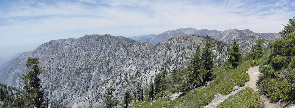
Trail to Icehouse saddle about as clear as the Santa Monica Freeway. It was a Monday so we only saw two other groups of hikers, but the trail to Icehouse is well trodden. The traffic drops off after the 5 way split* at Icehouse Saddle.

*The five trails from Icehouse Saddle:
1. Trail back down Icehouse Saddle.
2. Trail north to the 3 T's.
3. Trail east to Comanche and the Middle Fork of Lytle Creek
4. Trail SE to Cucamona Pk
5. Trail WSW to Ontario Pk.
The least travelled of the five trails was the trail down to Comanche Camp on the Middle Fork of Lytle Creek. I've been to Comanche recently from the east, but haven't done the stretch from the saddle to Comanche in years. Looks like interesting, seldom visited country. Of course it's a 1500' or so drop down to Comanche from Icehouse Saddle, so I'm sure that dissuades many.

Interestingly there are two "trails" or what appear to be well established trails leaving Icehouse saddle that aren't one of the five mentioned above. One goes up the S ridge of Timber which is a logical direct route to bag Timber, but another goes around to the steep east side of Timber. What the heck? Anyone know what this is? Maybe it's just people who thought the trail down the Middle Fork left precisely from the saddle (it actually leaves from a point about 50 yards south of the true saddle).


The trail to Ontario from the saddle is signed (as are all the trails). It's a bit obscured at the saddle due to people kind of going every which way to get onto the the trail but quickly becomes a clear, unified trail. Nicely forested up to Kellys Camp but thereafter goes through the burn area which is pretty shadeless. On one note, some small conifers were finally popping up in the burn area which is great news. The fire that burned the area over was in the 80's and the trees have never come back. These little conifers I saw may have been brought to life by the good rain years around 2005, but some are now looking a little distressed probably from the subsequent drought. Hope some of 'em make it. It'd be really nice to see the area regain its forest cover.

From the spot where the trail intersects the ridge above Kellys Camp (marked by a very weather beaten wooden sign leaning on a rock that indicates Big Horn Peak to the left and Ontario Peak to the right), you have to bypass three false summits. The trail consistently bypasses the false summits on the north side. One clue to the true Ontario Peak is that the true summit has some living trees on it within 20 or so feet of the top whereas the false summits are barren of living trees. The trail is pretty clear albeit not quite the freeway that the trail up Icehouse Canyon is, so you may not even need a tip, but there you have it just in case. You have to push through a bit of brush and climb over a couple of downed logs, but nothing major. The burned over area while hot does provide a continuous series of great views.

Ontario's summit has great views of the valley below and much of the San Gabriels from Cucamonga and the 3 T's to the east, to Baldy and Baden-Powell to the north to Waterman and the Twins to the NW all the way out to Mt. Wilson and even Mt. Lukens to the west. Hadn't really thought of Lawlor as much compared to Strawberry, but Lawlor really stands out from the summit of Ontario. Ontario has an interesting summit with several sizeable blocks of rock. A very large (now dead) pine tree is on the summit which is also odd (usually lightning takes out such trees before they get so large).

I drank water untreated from both of the springs mentioned. If you see no further posts from me, don't do the same. :)
User avatar
HikeUp
Posts: 3855
Joined: Thu Sep 27, 2007 9:21 pm

Post by HikeUp »

Good stuff.
Hikin_Jim wrote:...but another goes around to the steep east side of Timber. What the heck? Anyone know what this is? Maybe it's just people who thought the trail down the Middle Fork left precisely from the saddle (it actually leaves from a point about 50 yards south of the true saddle).
On my hike up to Ontario last month I noticed this trail too, mainly because someone with a dog was coming up it. He headed down Icehouse canyon before I could ask him where that trail went. There isn't much to see or do on that side of Timber! Nothing is visible on Google Earth either. Hmmm...

Nice job with the permit! :wink:

Here's a pic of the old weather beaten sign you mentioned...
Image
User avatar
Funyan005
Posts: 203
Joined: Tue Apr 01, 2008 11:17 pm

Post by Funyan005 »

Girlfriend and I are planning on heading up to Icehouse saddle and then deciding if we want to go further tomorrow, getting a 6 AM start time so hopefully wont be too hot as we start.
Never drank from the springs, but may try tomorrow! Depending how our water supplies go, Kelly's camp looks to be pretty close to the saddle and I've never been that way so I'll have to try some without a purifier! yippeee
Will check back in the morning ot make sure you're still posting.
User avatar
Hikin_Jim
Posts: 4686
Joined: Thu Sep 27, 2007 9:04 pm

Post by Hikin_Jim »

Funyan005 wrote:Girlfriend and I are planning on heading up to Icehouse saddle and then deciding if we want to go further tomorrow, getting a 6 AM start time so hopefully wont be too hot as we start.
Never drank from the springs, but may try tomorrow! Depending how our water supplies go, Kelly's camp looks to be pretty close to the saddle and I've never been that way so I'll have to try some without a purifier! yippeee
Will check back in the morning ot make sure you're still posting.
I gotta say that I feel just fine Image
User avatar
Funyan005
Posts: 203
Joined: Tue Apr 01, 2008 11:17 pm

Post by Funyan005 »

Wheres the spring/water in Kelly's camp? Is it painfully obvious when you reach it, or is it hidden off in the rocks?

Just curious, want to make sure I can find it if I get there!
User avatar
RichardK
Posts: 727
Joined: Sun Sep 30, 2007 12:33 pm

Post by RichardK »

Hikin_Jim - Nice trip report. I'm glad to learn that the springs are drinkable.

Funyan005 - Walk west across the camp away from the trail. Look for a grassy area. One of the springs is there.

Near the top of Cucamonga, you get a nice view of the Ontario ridgeline with all the false summits.

Image
FIGHT ON

Post by FIGHT ON »

Hikin_Jim wrote: Started on the trailhead at about 7:30 AM with about 1L of water. An earlier start would have been better but someone who shall remain unnamed overslept and held up the entire group. :oops:
not good.
FIGHT ON

Post by FIGHT ON »

RichardK wrote:Hikin_Jim - Nice trip report. I'm glad to learn that the springs are drinkable.

Funyan005 - Walk east across the camp away from the trail. Look for a grassy area. One of the springs is there.

Near the top of Cucamonga, you get a nice view of the Ontario ridgeline with all the false summits.

Image
Hey Taco. Richard got the camera thing goin on. When you gonna change the BIG picture?
User avatar
Hikin_Jim
Posts: 4686
Joined: Thu Sep 27, 2007 9:04 pm

Post by Hikin_Jim »

Funyan005 wrote:Wheres the spring/water in Kelly's camp? Is it painfully obvious when you reach it, or is it hidden off in the rocks?

Just curious, want to make sure I can find it if I get there!
See Richard's post, but I think Richard means west not east. Basically, when you get to Kellys Camp, which is marked with a sign, you'll find a large flat area. Go to the western most edge of the flat area. At the western most edge of the flat area, you'll find yourself overlooking a gully. On the southmost (left) portion of the western most edge of the flat area, you'll see a use trail leading toward a bright green spot consisting of a patch of short lush grass. Follow the use trail (it's maybe +/-30' long) to the grassy area and look for a small pipe (see the photo in the Kelly Camp Spring thread here in the Trip Reports section) coming out of the ground. You don't have to drop much into the gully. The use trail descends just a bit on a gradual incline. If you find yourself really dropping into the gully, you're off track. Be careful of course not to disturb the pipe when you collect water. It's flushed out continuously so long as it's undisturbed but you could shake loose something if you were to jiggle the pipe. There's a small pool below the pipe if you prefer to filter.

RichardK wrote:Hikin_Jim - Nice trip report. I'm glad to learn that the springs are drinkable.

Funyan005 - Walk east across the camp away from the trail. Look for a grassy area. One of the springs is there.

Near the top of Cucamonga, you get a nice view of the Ontario ridgeline with all the false summits.

Image
Nice pic, bro!
User avatar
RichardK
Posts: 727
Joined: Sun Sep 30, 2007 12:33 pm

Post by RichardK »

Hikin_Jim - Thanks for the correction. It is WEST!
User avatar
Mike P
Posts: 1005
Joined: Tue Oct 02, 2007 10:48 pm

Post by Mike P »

The last time we were at Kelly Camp (2 yrs ago) the gully that Hikin Jim referred to had MUCH more water than the pipe. If you head down the gully (north/NE) you should find lots of water. Has anyone been there recently?
User avatar
Hikin_Jim
Posts: 4686
Joined: Thu Sep 27, 2007 9:04 pm

Post by Hikin_Jim »

The gully looked dry as far as I could see when I was there on Monday. I did see some bright green down the gully a ways further, which may have indicated water close to the surface. I didn't investigate since there was plenty of water at the two springs.

I too believe I recall water in that gully from trips past. When were you there last? We've had two years of drought followed by a so-so year. Maybe the gully was flowing in a wetter year?
User avatar
Mike P
Posts: 1005
Joined: Tue Oct 02, 2007 10:48 pm

Post by Mike P »

Yeah, you're right, Jim. The gully may certainly be dry since I was last there in July '06. However, one needs to go down the gully quite a ways before the water is found.
User avatar
Hikin_Jim
Posts: 4686
Joined: Thu Sep 27, 2007 9:04 pm

Post by Hikin_Jim »

Ah, gotcha. Good 411 in case the pipes are ever dry.

Did you go all the way to the confluence with Delker Canyon or just stay w/in the little gully by Kellys Camp?
User avatar
Mike P
Posts: 1005
Joined: Tue Oct 02, 2007 10:48 pm

Post by Mike P »

We just stayed in the gully N of camp. On the USGS topo, the water is roughly between the letter "U" and the second "C" in the word "CUCAMONGA."
User avatar
Tim
Posts: 560
Joined: Tue Apr 08, 2008 8:55 pm

Post by Tim »

Hikin_Jim wrote:One goes up the S ridge of Timber which is a logical direct route to bag Timber, but another goes around to the steep east side of Timber. What the heck? Anyone know what this is? Maybe it's just people who thought the trail down the Middle Fork left precisely from the saddle (it actually leaves from a point about 50 yards south of the true saddle).
I checked out this mystery trail this weekend. I also noticed it in the past and figured it went down into the canyon. But all it does is go out about 50-100 feet then turn left and reconnect with the steep trail that goes directly up the south ridge to Timber.
User avatar
Hikin_Jim
Posts: 4686
Joined: Thu Sep 27, 2007 9:04 pm

Post by Hikin_Jim »

Tim wrote:
Hikin_Jim wrote:One goes up the S ridge of Timber which is a logical direct route to bag Timber, but another goes around to the steep east side of Timber. What the heck? Anyone know what this is? Maybe it's just people who thought the trail down the Middle Fork left precisely from the saddle (it actually leaves from a point about 50 yards south of the true saddle).
I checked out this mystery trail this weekend. I also noticed it in the past and figured it went down into the canyon. But all it does is go out about 50-100 feet then turn left and reconnect with the steep trail that goes directly up the south ridge to Timber.
lol so much for the great mystery. I was hoping for at least an abandoned mine or something. That trail is so wide, regular, and level that it looks more like a trail crew put it in than just the passage of feet over time.
Mike P wrote:We just stayed in the gully N of camp. On the USGS topo, the water is roughly between the letter "U" and the second "C" in the word "CUCAMONGA."
Got it. My memory banks thank you. :)
Post Reply