Baldora, Gold Dollar, San Antonio Ridge

TRs for the San Gabriel Mountains.
Post Reply
User avatar
dima
Posts: 1354
Joined: Wed Feb 12, 2014 1:35 am

Post by dima »

I'm working on visiting places on my mental to-do list, and checking them off this list. It's taking a while, but I'm slowly-but-surely making progress. On Sunday I went to the East Fork to hit Baldora Mine, Gold Dollar mine and the interesting half of San Antonio Ridge. This list implies a specific loop route, and when Zé had similar goals a few years back, he put together a similar trip. This means that everything is already documented, but I'll write it up anyway :)

Anyhow, I started at Heaton Flat, walked up to Coldwater Saddle, and traversed towards Coldwater Canyon behind Widman Ranch. I cleaned up the brush on this trail the last time I was here, and it is still passable. The heavy rains of last year are bringing the brush back, and it could use some more trimming. Anybody know how to trim back yucca quickly? Loppers work, but it takes a long time since you have to cut back every single tip. Is a machete better for this?

As before, the old trail becomes an old road, which is FULL of yucca. Then you drop into Dry Gulch. I followed the gulch up; there's a good use trail on the west side. The old truck is still there:

Image

I stayed in the creek bed above the truck, and somehow completely missed the Widco site from the last time. This was on the West side of the creek. A bit above there the gulch got some surface water, and the ruins of Baldora mine came into view on the East side.

Image

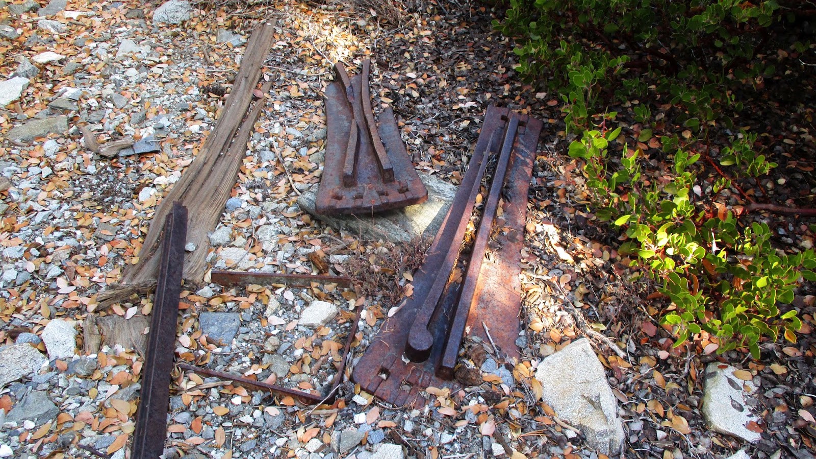
There's lots of stuff here! Besides the house was some sort of ore processing structure.

Image

And all sorts of miscellanea scattered around

Image

Image

There was a metal cover of some sort with a knob that could be set to "fast" or "slow"

Image

Image

I looked up the patent, and it IS a mining patent, but doesn't seem applicable: it's about electrically separating the copper in your ore. Maybe it works for gold too. Or maybe patent application numbers were different from patent grant numbers back then.

The house is sparsely furnished

Image

Image

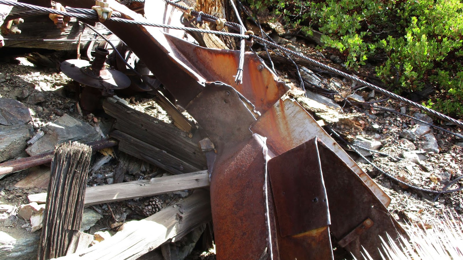
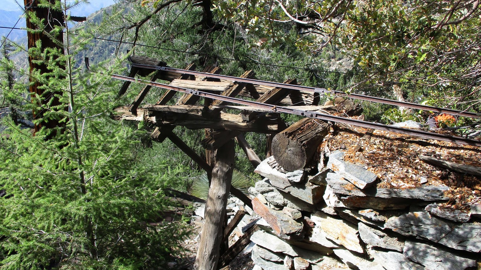
and the ore processing stuff is cool

Image

Image

Image

I still had a lot to do, so I didn't linger too long. There was no obvious adit anywhere, and I'm certain I missed lots of stuff. CrazyHermit: you mentioned the last time that this is Widco AND Baldora. Does that mean that the two sites are part of a single operation? The ore was dug from the site on the West side, then transported to THIS side to be processed?

Onwards. When Zé was doing this, he tried to stay on old trails as much as possible. I had no faith that these would exist in any form, much less be useful. So I did a bit of armchair reconnaissance before I headed out, and decided that the best course of action would be to stay in Dry Gulch as long as possible, and to turn right into a gully that goes more or less to the Gold Dollar Mine site. This looked to be clear of brush, and less steep than the rest of the available terrain.

The plan was sound. But in reality, I hit this:

Image

(Sorry for the bad photos, my camera couldn't handle the lighting conditions.) This thing is sheer and HUGE, maybe 50ft. No way I'm climbing this thing. There was a doable-looking scree slope on the right, so up I went. Initially I was just going to bypass the falls, but I heard some rocks falling above, and just kept climbing to chase imagined sheep. There doesn't seem to be a lot of brush anywhere in this area. It's pretty steep, but all seemed manageable. Lots of scree here, and it's not too difficult finding sections with larger (and more stable) rocks. I did end up on all fours a lot, for traction and balance mostly, not battling brush. I guess the other side of this ridge (towards Eagle Mine) is supposed to be worse, but I did ok here. Didn't find any sheep, or mapped trails, but there're some animal trails here and there; nothing particularly useful, though.

My main GPS refused to work in the canyon. The backup GPS sorta worked, but I had some doubts about where exactly I was. Finally, I came up on a rusted bucket of some sort, and climbed straight up to see rusted out fuel barrels, and eventually, the Gold Dollar Mine site. It's a wrecked pile of stuff:

Image

This is the ore processing area, I think.

Image

Image

Image

Image

Image

On top is an ore hopper

Image

that feeds the rest of the pile. This mine is completely insane. Even more than Stanley-Miller, it's difficult to imagine how they decided this was a good idea. One open question is: where did their water come from? The obvious sources are all significantly below.

I hung around for a bit. Wasn't making great time, and was a bit concerned that I still had to gain San Antonio ridge, and then cross the notches which, by the way, look like this from the site:

Image

Gunsight notch is the one on the right. I didn't take the time to look for the residential area. Anybody know where it is? I climbed up towards the ridge, and found one of the cables almost on top of San Antonio Ridge. I guess the adit is somewhere along the cable?

Nearing the top you get better and better view of the notches:

Image

Despite our non-winter, the North side of Baldy has some snow:

Image

I got to the ridge and turned West. I was surprised to see that this ridge gets some maintenance: many trees, big and small, were cut down:

Image

Is this the forest service trying to reduce the number of lightning rods? Some of the cut plants were smaller ones, on the climbing route. And some cuts were there clearly to make it easier to pass

Image

What's the deal? Gunsight notch was as advertised: VERY intimidating-looking, but quite easy in practice.

Image

Image

I took my sweet time, and the whole ridge felt fine. The rock is generally solid, and the holds are good and plentiful. Eventually you can see the W15 post at the top of the last bump

Image

And then you're at the top, and can look at Catalina Island and the barges on the water.

Image
User avatar
stonehillnews
Posts: 72
Joined: Thu Dec 15, 2016 1:31 pm

Post by stonehillnews »

What route did you follow back down?
User avatar
Sean
Cucamonga
Posts: 3787
Joined: Wed Jul 27, 2011 12:32 pm

Post by Sean »

You sure packed a lot into that trip. Thanks for the fascinating report.

dima wrote:Anybody know how to trim back yucca quickly?
Grab a clump of blades and cut them with a Rambo knife, or try a small folding saw. That's how I do it now. Loppers were slow and unreliable for such work.
Is this the forest service trying to reduce the number of lightning rods? Some of the cut plants were smaller ones, on the climbing route. And some cuts were there clearly to make it easier to pass

What's the deal?
I imagine the route gets maintenance from groups that do the traverse. Smaller limbs were probably cut with a folding saw. Sometimes crews cut down dead trees to prevent them from falling on people or fueling wildfires.
User avatar
headsizeburrito
Posts: 279
Joined: Wed Nov 15, 2017 1:18 pm

Post by headsizeburrito »

Nice report, bummed I wasn't able to join you!

I've wondered about those cut trees and branches too. None I recall seeing the times I've been there looked recent, but some (like that branch you posted that's pretty near the summit of Iron) clearly aren't that old either. My impression was that the bigger trees were all cut years ago by whatever management agency and the smaller branches along the way were cut by various hikers to make things a little easier. I did a little bit of work myself on the east end of the ridge ahead of the Death March and have considered doing more, but there is so much and it's so thick that the only efficient way would be a gas powered hedge trimmer...

How long did it take you to reach Baldora and then Gold Dollar? Now you've got me wanting to do a little mine tour (I haven't seen either of those ones before) and then maybe do a little trail work along the ridge if time allows. I've already got hand pruners and a pruning saw and just got a small pair of loppers to do some work in other places as well.
User avatar
dima
Posts: 1354
Joined: Wed Feb 12, 2014 1:35 am

Post by dima »

stonehillnews wrote: What route did you follow back down?
Took the main trail down (South ridge). It's a nice thing about this peak: you can ascend using a number of cross-country approaches, and come back on a trail; in the dark, if need be.

Sean wrote: Grab a clump of blades and cut them with a Rambo knife, or try a small folding saw. That's how I do it now. Loppers were slow and unreliable for such work.
That sounds like a good idea. I'll visit my local home depot before the next such excursion.

headsizeburrito wrote: How long did it take you to reach Baldora and then Gold Dollar? Now you've got me wanting to do a little mine tour (I haven't seen either of those ones before) and then maybe do a little trail work along the ridge if time allows. I've already got hand pruners and a pruning saw and just got a small pair of loppers to do some work in other places as well.
I made OK time, but not anything great: 2 hours to the saddle, 3 to Dry Gulch and 5 to Gold Dollar. The entire roundtrip took 11 hours, with maybe 1.5-2 hours of breaks. Let me know if you go exploring over there: I want to at least find the residential area at the Gold Dollar site.
User avatar
SGBob
Posts: 101
Joined: Wed Jan 07, 2015 12:47 pm

Post by SGBob »

dima wrote: Anybody know how to trim back yucca quickly? Loppers work, but it takes a long time since you have to cut back every single tip. Is a machete better for this?
Image

Just cut the very tips off. Lets the plant live without much injury and people can brush by without getting stabbed.
User avatar
Ze Hiker
Posts: 1430
Joined: Mon Jul 28, 2008 7:14 pm

Post by Ze Hiker »

Nice! Brings back fun memories.
I remember so many damn flies trying go straight up to Gold Dollar Ridge, so steep so there must be an easier way.
As for residential area, I can't remember exactly but if you look at the geo-tagged photos in the TR you linked to, you should be able to locate it.
Now please go complete the old Big Horn Ridge trail from Coldwater canyon please :)
User avatar
dima
Posts: 1354
Joined: Wed Feb 12, 2014 1:35 am

Post by dima »

Your gps tracks aren't accessible anymore. You used some commercial service to host them, and they're now demanding payment. If you post them somewhere else, I won't complain :) It'll take me a little while to get over there, but I'll make sure I know where I'm going this time. Oh, and my route up to Gold Dollar was steep, but not all that noteworthy otherwise. No flies. No brush. Stable-enough ground. I lucked out probably.

As for the trail from Coldwater canyon, you can clearly see it on old aerials. It went up and over Bighorn ridge to Cattle canyon. The recent aerials make me think it's now a brushy mess, but maybe not...
User avatar
Ze Hiker
Posts: 1430
Joined: Mon Jul 28, 2008 7:14 pm

Post by Ze Hiker »

Looks like it links to AllTrails...looks like you can at least see geo-tagged pictures, is that correct?

But you have to pay to download gpx files? Ridiculous. When I have time I'll figure out where to share them. Any suggestions?
User avatar
dima
Posts: 1354
Joined: Wed Feb 12, 2014 1:35 am

Post by dima »

I can see the photos and probably can scrape the gps coords, but it's a pain. Now that I think about it, I think I did scrape the gps track (points only) at some point in the past. Your blog is still up, and it's serving data (the blog). Can you not serve the gps track too?
User avatar
Ze Hiker
Posts: 1430
Joined: Mon Jul 28, 2008 7:14 pm

Post by Ze Hiker »

dima wrote: I can see the photos and probably can scrape the gps coords, but it's a pain. Now that I think about it, I think I did scrape the gps track (points only) at some point in the past. Your blog is still up, and it's serving data (the blog). Can you not serve the gps track too?
There was some issues with hosting it, but I uploaded to dropbox and shared a link that you can download. Go to http://socalhikes.com/gpxfile/
User avatar
dima
Posts: 1354
Joined: Wed Feb 12, 2014 1:35 am

Post by dima »

wrote: There was some issues with hosting it, but I uploaded to dropbox and shared a link that you can download. Go to http://socalhikes.com/gpxfile/
Thanks! I'm sure many will appreciate this. I'll ping you when dropbox will decide they want to profit off you too :)
User avatar
tekewin
Posts: 1195
Joined: Thu Apr 11, 2013 5:07 pm

Post by tekewin »

Henry and I did this hike yesterday from Heaton Flat looking for Gold Dollar Mine. We found two ruin sites, but missed the lower one Dima found (probably a couple hundred feet below the first one we found), and also missed the residential area Ze found. We followed the cables up to a second ruin site, the one with the mine car rails that scottawr posted pictures of from his trip. The Garmin topo marked the mine east of this area, but I don't really trust a lot of the marks in the Garmin topo. We decided to continue following the cable up and it ended at a dead tree just below San Antonio Ridge. We completed the hike over the ridge to Iron then down the trail.

I didn't spend enough time researching all the previous reports. The socalhikes.com site is offline, but images can still be found in the wayback machine. What I am wondering is if anyone has ever found an adit of the actual mine? Maybe the Garmin topo had the right spot marked but it doesn't make sense that the mine would be off the line of the other ruin sites.

Image
Near the ore hopper site

Image
The second ruin site, about 300' higher

Image
User avatar
dima
Posts: 1354
Joined: Wed Feb 12, 2014 1:35 am

Post by dima »

Oh cool! Glad you made it out there. The main site I was at the last time was where the USGS topo marks a square (at about the 6300ft level). I then climbed straight up to the ridge, went left at the top, and ended up on San Antonio Ridge. Near the top of SAR the subsidiary ridge met some cables from below and left. One of your sites was at the other end of the cables? What about the other one?
User avatar
tekewin
Posts: 1195
Joined: Thu Apr 11, 2013 5:07 pm

Post by tekewin »

dima wrote: Oh cool! Glad you made it out there. The main site I was at the last time was where the USGS topo marks a square (at about the 6300ft level). I then climbed straight up to the ridge, went left at the top, and ended up on San Antonio Ridge. Near the top of SAR the subsidiary ridge met some cables from below and left. One of your sites was at the other end of the cables? What about the other one?
The first site was at 6443' (I think that is what you called the ore hopper) and the second one with more stuff (and the mine car rails) was at 6822'. Both sites had cables running through them. We should have descended down to 6300' for the major ruin site, but we followed the cables all the way up until they stopped anchored to a dead tree. Is it possible there are two sets of cables?

Did you find any adits or shafts around the lower site? I don't think I read any reports of anyone finding an adit for Gold Dollar.
User avatar
dima
Posts: 1354
Joined: Wed Feb 12, 2014 1:35 am

Post by dima »

I didn't find any adits. I wasn't making great time, so I didn't spend too long looking for them. USGS calls out two separate tunnels; sometimes those are precise. Did you check those locations? How long did the loop take you?
User avatar
tekewin
Posts: 1195
Joined: Thu Apr 11, 2013 5:07 pm

Post by tekewin »

We really weren't making great time. It took us 16 hours for the full loop. Since we still had to make it over the spicy part of the ridge and Iron, we didn't spend a lot of time looking around. I know Henry wants to go back. If I went back, I'd probably start on Baldy and end at Heaton, so most of it would be downhill from the ridge. Is the Y-like symbol on the USGS topo a tunnel?
User avatar
dima
Posts: 1354
Joined: Wed Feb 12, 2014 1:35 am

Post by dima »

tekewin wrote: Is the Y-like symbol on the USGS topo a tunnel?
Yep
User avatar
Sean
Cucamonga
Posts: 3787
Joined: Wed Jul 27, 2011 12:32 pm

Post by Sean »

Does anyone have a great guess about the location of an entrance for this mine? If it's buried, any ideas where to start digging?
User avatar
dima
Posts: 1354
Joined: Wed Feb 12, 2014 1:35 am

Post by dima »

I'd check the USGS-labelled locations and stuff on the upper end of the cables. Tekewin's last photo above looks like a rail terminal. Following the rails backward should point to the adit location.
Post Reply