Above Bear Creek

TRs for the San Gabriel Mountains.
Post Reply
User avatar
dima
Posts: 1354
Joined: Wed Feb 12, 2014 1:35 am

Post by dima »

So I keep hearing Triplets this or Triplets that. People keep hitting that peak to prove themselves. I don't feel like driving way out to Buckhorn to prove myself on a semi-known route, but driving to the West Fork, and trying out a beta-less (to me) approach sounds more appealing for some reason. I COULD do it from Twin Peaks, but I don't feel like it. Or something.

From earlier posts on this board, an approach from the South was said to be difficult, and on Monday I went out there to see what the fuss is about. Now that I've seen it, the fuss appears well warranted.

Looking at the topos, the aerial imagery and the (very useful) caltopo slope shading I decided the best approach would be the gully between the S and SE ridges of the peak. The plan would be to take the trail to Bear Creek, follow the creek a bit South until the gully comes in from the right, follow the gully until maybe 5000'-5200' of elevation or so, then climb up to the S ridge on the left, and follow that the rest of the way. It doesn't look GOOD, but the whole area is very brushy and steep, and that looked most promising to me. This should help:

https://caltopo.com/m/SC8V

The plan was to try to get as far as I could, and I didn't expect to finish. But I did want to maximize the chances, so I got to the trailhead super early, and started walking at 4:40AM. This was actually a bit too early, and I killed some time by goofing around with some long-exposure photos of the peak at night

Image

As intended I got to Bear Creek a bit after it was light enough to walk without a headlamp, at 6:40AM or so. The trail up to Smith Mountain saddle is in perfect shape. The trail to the creek is great in the upper half. The lower half has a bit of brush, but nothing terrible.

I walked the maybe 0.5 miles to the junction with the gully, and turned right. This gully is bone dry, but the lower section is full of dry brush. The going becomes painful immediately. I pushed through sections of it, then found some use-trail-looking things on the unstable left wall, and was able to make a bit of progress. This was quickly interrupted by a sizeable dryfall:

Image

I tried out several wide bypasses. The ground here is particularly unstable, and nothing looked appealing. It was still early, so I ended up climbing directly up the face of this thing, with the understanding that I'd do something else on the way down. Soon thereafter is another large dryfall:

Image

And another:

Image

Both were bypassed on the right, with a wide arc. Also steep, brushy and loose. I'm going to be using these words a lot. The going was slow, but I was making progress. At elevation 2800' or so, the gully splits. I went left, and here the dryfalls ended, and there was a nice section of clear, rocky (dry) streambed that was easy to walk on.

Up to this point I'd see a use trail every once in a while, but it was not good enough or consistent to really be helpful. This didn't make a lot of sense. I haven't heard of this route being used by people to get to the peak or anywhere else. And it's not an obvious animal route either. The deer are better equipped than me to handle this pain-in-the-ass place, but I doubt they would CHOOSE to be here. As I was pondering, I saw this:

Image

and it started making sense. This particular operation was no longer active. For one thing, there was no water in the canyon anymore, aside from a few stagnant pools here and there. And the hoses were punctured and severed in multiple places.

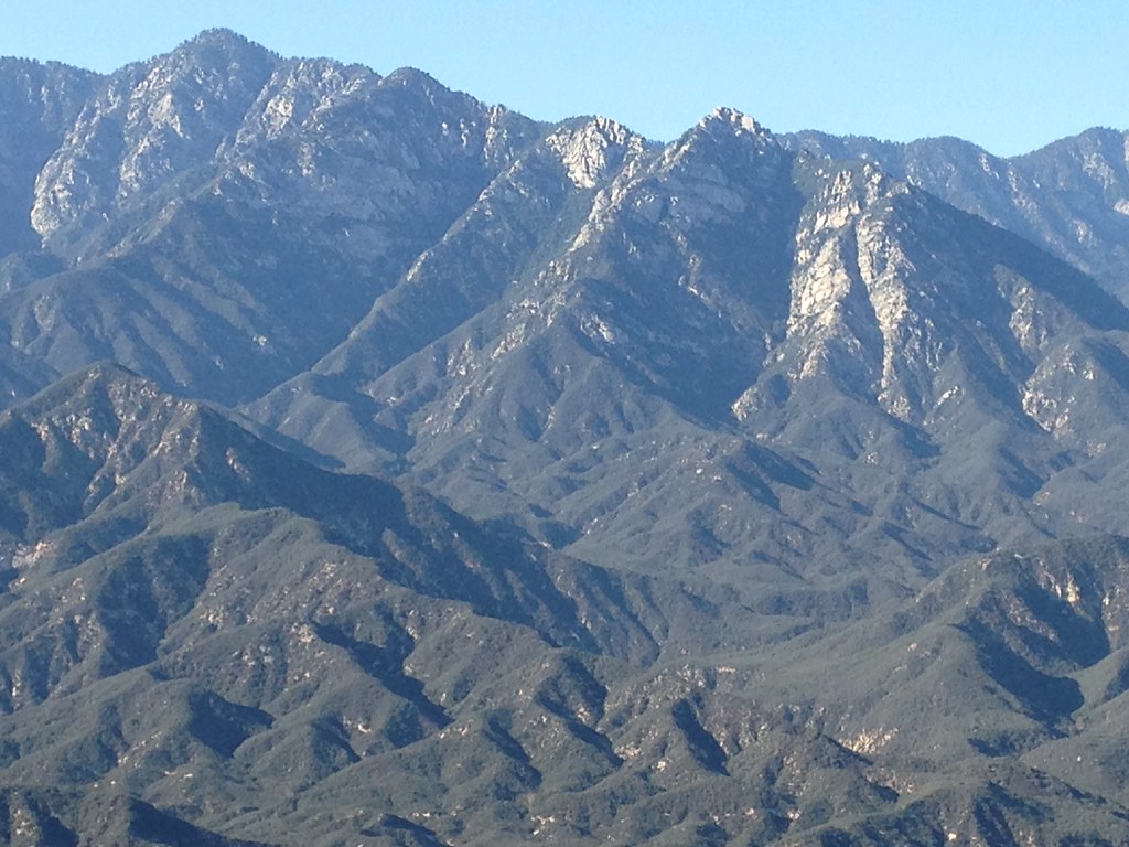
I kept pushing. I saw some pines coming up, and I climbed up to them to take a break. There was a nice view here:

Image

Image

I don't thing either of these are the peak, but rather points on the ridge on either side. Here you could also see what would happen if one leaves the gully:

Image

Yep, I'm staying in the channel, thank you very much. So yeah. I kept slowly moving forward. There was noticeable progress. For some reason there was still a use trail here and there, even here, so I don't know what that's all about. Eventually the canyon started closing in, and steepened considerably:

Image

Soon (elevation 3900' or so) I was looking at a large dryfall

Image

Image

Image

This was one of the shortest days of the year, and my turnaround time was approaching. I REALLY didn't want to be in this gully in the dark, so I decided this is where I'm turning around. I get overly cautious on these trips when I'm by myself, so here I made a silly mistake. The obvious question here is "you turned around at a dryfall, but was there a bypass?" and my answer is "I have no idea!" There was no obvious bypass. You could try to figure something out on the right wall, and nothing looked clearly doable safely. But I didn't even try to find a route. My guess is that maybe one could get around this. But the topo says this is only the beginning of the very steep section, and it looked like there was another dryfall immediately after this one. So even if you could get around this one, there're very likely others above it, and it's not at all obvious that they could all be negotiated safely. So I GUESS this isn't a viable route, but I can't say that with certainty.

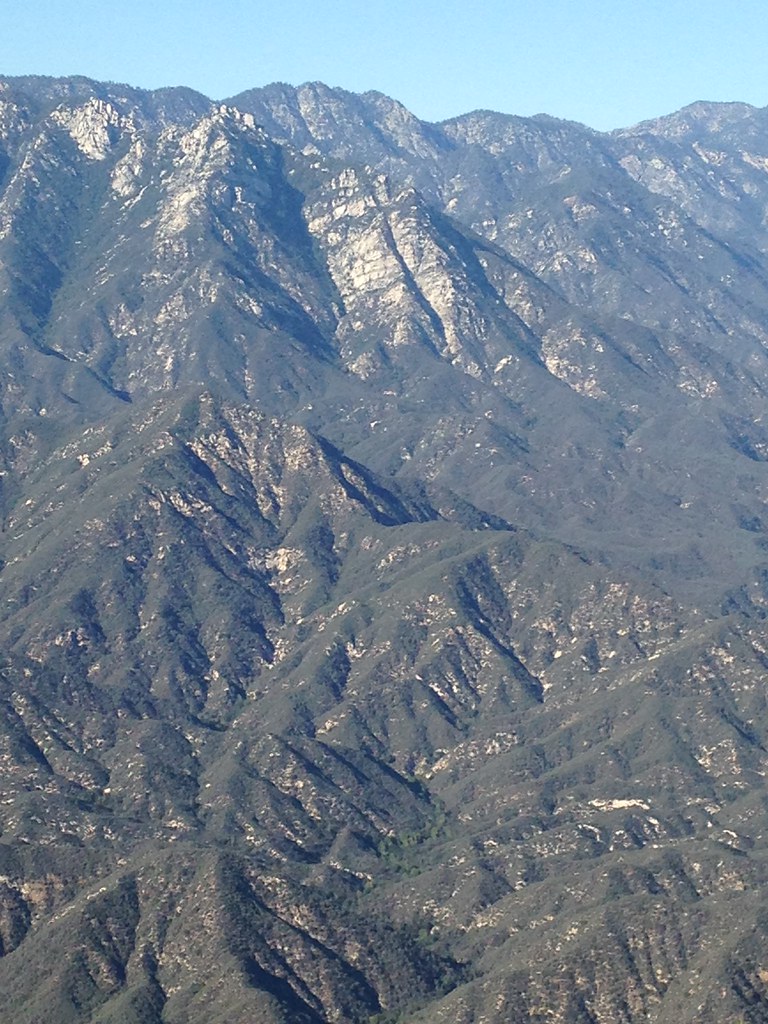
I hung out here for a bit, looking at the ridge to the South

Image

The way back was as brushy as before, but went by much faster

Image

Image

I took a black-hose-related detour, and after a bit was standing at the top of the upper-most of the dryfalls near Bear Creek. Managed a sketchy descent down the face. The next one wasn't as accomodating

Image

This demanded the wide bypass. I climbed the ridge to the left to get around the dryfall, but looking at the other side I could see and hear Bear Creek. So instead of dropping back into the gully and then having to negotiate at least another dryfall and lots of brush, I dropped straight to Bear Creek from here. From Bear creek, this ridge looks like this:

Image

If somebody comes back this way, I strongly recommend this shortcut in both directions. About 400 yards above the mouth of the gully, climb the slope in the photo to the saddle, walk upstream (right) a bit to clear the dryfall, and drop down past it. You save a non-insignificant amount of work.

So yeah. The return trip went much faster than the climb, and I beat sunset by a lot. Really should have at least tried to clear the highest dryfall. On the climb up to Smith Mountain saddle I encountered the only person I've seen that day: a forest service volunteer who was wrapping up some trail work, and heading back. Apparenly he's been to Triplet Rocks decades ago, in the age before internet trip reports and gps tracks. That is badass.

I didn't get the peak, but I did complete the approach and the approach to the approach. And I retrieved 5 birthday balloons and explored a new (to me) part of the forest. So it was a good day.

Who's trying a Southern approach next? Taco? AW? Have both of you given up on this? :)
User avatar
AW~
Posts: 2043
Joined: Mon Oct 01, 2007 12:00 pm

Post by AW~ »

The second picture is 6151(Triplet). Awesome pics though...I can appreciate the effort to get em. The people who travelled around decades ago had it easy cause it had just burned 100% of the area. Now as you can see its a mismanaged mess.

Where you went 'left', my thought is to hang out briefly on the 'right' gully. Your path in red, mine in green(not exact). I took a look at your path from a distance(like 6 years ago) and would say the difficulty in that plan would just be starting with that 3900 dryfall. Its on my list still...somewhere, but my #1 for the wilderness next year is Little Mermaid peak...and I usually do only 1 in that area per year. This year I overnighted in the self-proclaimed exploration preserve of the San Gabriel wilderness, so I'll have to stay mum on that tr. But yeah, if I dont get Little Mermaid done in 2018, I'll never get it done...which is cool with me, but getting there would be cool too :) Guess Im on the West Ridge crew...vs the East ridge(Triplet) crew right now.
bc.png
User avatar
headsizeburrito
Posts: 279
Joined: Wed Nov 15, 2017 1:18 pm

Post by headsizeburrito »

Looks like quite an adventure, and you made good progress on a novel approach! Your exploratory routes always give me ideas. I'm also kind of impressed at the work involved in setting up a grow op in places like that...

At those lower elevations the dense brush may just be unavoidable, but it would certainly be very cool to find a reasonably passable route from the south. I'm basic and doing it for the instagram likes, but I still want to do Triplets from the standard route because I like scrambling more than bushwhacking. With the days finally getting longer (hooray!) I'd certainly be interested in attempting a southern approach at some point after that however.

Nice pictures as always!
User avatar
dima
Posts: 1354
Joined: Wed Feb 12, 2014 1:35 am

Post by dima »

AW: the green route is something you are/were planning, or you have done it? From the map it looks as reasonable as anything else (i.e not very reasonable), although approaching via the shortcut I found might be easier then going up and over pt 3220. Do you have any photos from about the dryfall at 3900'? And I forget, which one is Little Mermaid? 5014 or 4654? What's the approach?

headsizeburrito: you won't get an instagram like from me, but do post a TR :)
User avatar
tekewin
Posts: 1195
Joined: Thu Apr 11, 2013 5:07 pm

Post by tekewin »

That was a valiant badass attempt! I've also dreamed of making a run from the bottom, but dropping down from highway 39 below Islip. That way is shorter but probably just as troublesome. I was surprised to see the big dry fall obstacles you ran into early. Your photos are great. I wonder if that black tubing didn't wash down from higher up. There have been several reports of grow operations north of there.

A couple of years ago, someone on facebook claimed to have climbed triplet from below, but provided not a single photo of the trip. I forgot the name, but Sean might remember. I am very skeptical of that claim.

Triplet is very, very hard and it looks like very, very, very hard from the bottom.

Thanks for posting this and making the effort! It answered a lot of questions I had about Bear Creek itself and what the steep sections below triplet look like.
User avatar
AW~
Posts: 2043
Joined: Mon Oct 01, 2007 12:00 pm

Post by AW~ »

The only photo I have of that 3900 drop is a old one from 2007....to the right of the yellow labeled 3900. I have a hires photo of the area above 3900 in case you want it from the winter of 2011...not looking reasonable at all. Probably a cliff face at the top anyway.
tr1.jpg
User avatar
dima
Posts: 1354
Joined: Wed Feb 12, 2014 1:35 am

Post by dima »

Where in the world did you take this from?
User avatar
AW~
Posts: 2043
Joined: Mon Oct 01, 2007 12:00 pm

Post by AW~ »

Thats a weak zoom from pk 3705/Mermaids. Heres what the view looks like non-zoomed...
User avatar
HikeUp
Posts: 3861
Joined: Thu Sep 27, 2007 9:21 pm

Post by HikeUp »

There are some pictures of the area taken from Smith Mtn. in this album...

https://www.flickr.com/photos/hikeup_pa ... 4448092951
User avatar
walker
Posts: 248
Joined: Mon Apr 08, 2013 11:14 pm

Post by walker »

Nice work, Dima.

I tried that same approach about 15 years ago and backed off way before you did. Not easy travel at all in that area, you accomplished a lot!

Here are a couple of blurry views of that area seen from Pine Mt. from about 2 years ago.

Image


Image

Regarding the black tubing - I've been exploring northern approaches to the triplet area via the upper reaches of west fork Bear Creek over the last 5 or 6 years. I've run into active grow operations in that area on three separate occasions as well as a fourth abandoned grow camp along with all the trash and devastation they usually leave behind. There are water sources on the north side of triplet ridge and they even had a cistern or well constructed in an unlikely spot on a ridge top in one case. I suspect they change location each season, who knows if they can even do year-round growing by alternating north side and south side. This particular group seems to be into trail building as well, so if you come across lots of cut limbs and very obvious paths of travel, you might be near one of their sites. I've never actually stumbled into the grow itself, they usually have a watcher, so on the two times I've encountered individuals in these spots, I've just turned around and made my exit.

My thinking for the northern triplet approach was that it's preferable to travel through the piney country on the north side to the brushy zone on the south, but that area is where I keep bumping into these shady characters. It's a shame because it's truly beautiful wooded country in there with mature giant cedar forests and rocky outcrops. Traveling alone in the backcountry can be very rewarding, but also worrisome when you come across stuff like that. Be safe and enjoy, y'all.
User avatar
RichardK
Posts: 727
Joined: Sun Sep 30, 2007 12:33 pm

Post by RichardK »

It will be interesting to see what becomes of the grow operations now that pot is legal. The end of Prohibition put the moonshiners out of business.
User avatar
Tom Kenney
Posts: 371
Joined: Sat Sep 29, 2007 7:51 pm

Post by Tom Kenney »

RichardK wrote: It will be interesting to see what becomes of the grow operations now that pot is legal. The end of Prohibition put the moonshiners out of business.
There's some discussion about the tax being onerous enough to give the black market a boost. I'm all for taxing the stuff...but sometimes 'unintended consequences' are obvious (and maybe not unintended?).
User avatar
dima
Posts: 1354
Joined: Wed Feb 12, 2014 1:35 am

Post by dima »

Thanks for the photos. I can see the kink in the canyon that I think is the 3900' area. No more kinks above there, but it looks very steep. walker: I followed the tubing to the actual grow site. They found a flat bench above the creek and partially cleared out the brush, leaving the big manzanita trees. You still wouldn't be able to see the site from a chopper. If there was water in the canyon and it wasn't a major pain in the butt to get to, the grow area would be a really nice campsite. I'm REALLY impressed these people set up any sort of operation there. They probably set up ladders to clear the dryfalls, but even so, it took work. And this site was really clean: there was just a single piece of black tarp, and I packed it out. Was there any identifying graffiti in the other sites you've seen?
User avatar
anarchist
Posts: 75
Joined: Sat Jan 04, 2014 7:57 am

Post by anarchist »

I hiked through the area north of triplets back in August. No signs of current grow activity. I was impressed by finding boot tracks in some extremely unlikely spots. And I did see small signs of grow operations scattered across the whole area. Like Walker said this area is a beautiful forest. What a shame that grows have infected it.

With legalization, growers will have other more viable options to these types of operations. Legal growers can divert products to the black market and avoid taxes. Legal backyard growers and retail markets will level the playing field for street sales making it hard for these types of grows to be profitable in the future. My two cents.

If others are interested in this area but would not go alone. Let me know, I'd like to go back again.

http://drive.google.com/file/d/1SWSCbtPJJ8SF-8D_ij70M68N1j7bvfCp/preview
User avatar
walker
Posts: 248
Joined: Mon Apr 08, 2013 11:14 pm

Post by walker »

Hi Dima, no doubt the guys who grow back in these remote areas put in a lot of work. I was blown away by this cistern structure built out of logs and tarps that was almost as large as one of the concrete circular ones you find beside fire roads. I suspect water was being diverted into it from a running creek about a mile away in a rugged gully on the north side of triplets ridge. Out of this cistern thing, several strands of black tubing snaked away downhill on each side of the ridge to feed the actual planting sites. I don't think these serious backcountry grower guys are into tagging or any of that, at least I haven't seen it around. The actual abandoned grow sites I've been to seem to be very well tended and clean, but the lookout points or campsites usually can be found by the piles of trash or beer cans lying around. The access and harvest trails they've built might be very useful paths for folks like us if their operation is not viable in the future.

Anarchist, nice job on exploring the remote country in there. Looks like you made really good time and saw a lot of the area. So the orange is the trip out and the blue is the trip back? About halfway down your initial orange descent ridge is where I ran into one fellow half in the bushes keeping a lookout and had a kind of weird conversation with him before turning around and leaving. On later visits I found that his spot was marked by beer cans.

Another time I tried to shortcut directly from the sharp canyon bends on your orange route directly over a pair of easy ridges to the terminus of your blue line. A brand-new trail led me to the top of a broad ridge where I found the cistern and another watcher sitting by the trail. That time I didn't hang around to have a chat and just headed uphill to take the long way home following the ridges to twin peaks and out.

I've also seen bits of tubing and more trash in the area between twin peaks saddle and your orange line, not to mention almost stumbling into another grow in Devil's canyon on the other side of the saddle while somebody was there watching it. I'd guess it's the same individuals gradually moving around the area from season to season so just be careful when in that zone. I'd love it if they'd just clear out, because it really is an otherwise pristine and gorgeous area. I'd love to visit again as long as I know the grow season is over!
User avatar
dima
Posts: 1354
Joined: Wed Feb 12, 2014 1:35 am

Post by dima »

Those sites sound really interesting, and it'd be cool to check them out when the growing season is done. Which is when, exactly? I'm always interested in checking out new areas with new people, so definitely ping me next time either of you go up there.

anarchist: I can't quite tell from your map: where did you end up? Did you gain the Twins-Triplet ridge?

Oh and regarding the graffiti, the people working the gully in this TR DID leave their mark. What does this say?

Image
User avatar
Sean
Cucamonga
Posts: 3787
Joined: Wed Jul 27, 2011 12:32 pm

Post by Sean »

tekewin wrote:

A couple of years ago, someone on facebook claimed to have climbed triplet from below, but provided not a single photo of the trip. I forgot the name, but Sean might remember. I am very skeptical of that claim.
Dan Bay says he did it from Bear Creek (north approach) on April 1, 2016.

IMG_20180111_121307.jpg


I spoke to him at a party and talked about the route. He says he left a cairn where he started up the ridge.
User avatar
dima
Posts: 1354
Joined: Wed Feb 12, 2014 1:35 am

Post by dima »

I feel like nobody should do anything doubtful on April 1st. Raises all sorts of questions.
User avatar
Sean
Cucamonga
Posts: 3787
Joined: Wed Jul 27, 2011 12:32 pm

Post by Sean »

dima wrote: I feel like nobody should do anything doubtful on April 1st. Raises all sorts of questions.
The unsatisfactory report and lack of pictures also didn't help, but the guy either did it or lied straight to my face. He seemed honest to me.
User avatar
HikeUp
Posts: 3861
Joined: Thu Sep 27, 2007 9:21 pm

Post by HikeUp »

Where did Dan Bay enter Bear Cyn. from? Waterman-Twin saddle? Kratka (similar to anarchist's route)?

An aside: why do I see anarchist's name and read it as antichrist?
User avatar
Sean
Cucamonga
Posts: 3787
Joined: Wed Jul 27, 2011 12:32 pm

Post by Sean »

HikeUp wrote: Where did Dan Bay enter Bear Cyn. from? Waterman-Twin saddle? Kratka (similar to anarchist's route)?
The Kratka-Waterman saddle across from the Buckhorn exit. It's actually the west fork of Bear Creek. You don't hit the main branch on this route.
An aside: why do I see anarchist's name and read it as antichrist?
Take a break from the Scandinavian black metal and switch to prog for awhile.
User avatar
HikeUp
Posts: 3861
Joined: Thu Sep 27, 2007 9:21 pm

Post by HikeUp »

lol
User avatar
anarchist
Posts: 75
Joined: Sat Jan 04, 2014 7:57 am

Post by anarchist »

Not sure how this guy would have gone? To get to Triplets from the North and not take the route Walker is considering would seem improbable in the time he claims. And I wouldn't consider Walkers route an East ridge? If his East ridge to Triplets was accessed from the drainage I was in he would have to travel lower(east) than my turn around point, likely to the junction with Bear Creek.
Sean wrote:
The Kratka-Waterman saddle across from the Buckhorn exit. It's actually the west fork of Bear Creek.
The area I looped is unnamed middle fork of Bear Creek.
HikeUp wrote: An aside: why do I see anarchist's name and read it as antichrist?
Satan was taken so I tried antichrist and it was taken! Maybe I should have tried Mike?
User avatar
HikeUp
Posts: 3861
Joined: Thu Sep 27, 2007 9:21 pm

Post by HikeUp »

lol lol
User avatar
dima
Posts: 1354
Joined: Wed Feb 12, 2014 1:35 am

Post by dima »

I guess somebody has to go climb the Triplets (from below!) and see if this Dan Bay's name is in the book.
User avatar
tekewin
Posts: 1195
Joined: Thu Apr 11, 2013 5:07 pm

Post by tekewin »

I think the graffiti says MS-13, one of the worst and most notorious gangs. https://en.wikipedia.org/wiki/MS-13. Bad hombres. These are not people I would want to meet in the woods.

See the similarity to this tattoo:

Image
User avatar
Taco
Snownado survivor
Posts: 6010
Joined: Thu Sep 27, 2007 4:35 pm

Post by Taco »

The rock looks pretty good.

I doubt I’ll ever try it again.
Post Reply