Baldy holiday

TRs for the San Gabriel Mountains.
Post Reply
User avatar
JeffH
Posts: 1169
Joined: Sun Nov 28, 2010 7:09 am

Post by JeffH »

I joined the crowds on Monday to walk up Baldy, I hadn't been there in over a year! The drive up was nice, those yellow flowers are really blooming now. My intent was to go up the bowl trail and return via backbone, but in conversation with some folks on the road I completely missed the turnoff and found myself heading to the notch. Being flexible, I figured I'd give this route a shot, I think I've only walked up the road once before. Walked down plenty of times.....
I stopped at the Notch to top off the Camelback and went up one of the ski runs to the road. I briefly debated simply heading back down to the restaurant for a cheeseburger and beer but once more turned uphill. There were plenty of people out this day, it was nice to be above the clouds and fog that blanketed the homeland of Claremont in the morning. Once I reached the last ski lift station it got very windy and cool, making the backbone a little more interesting. I saw a couple patches of snow on the north side of Baldy, my drive up to Adelanto today revealed another at the top of Harwood. They will be gone by the weekend so winter is definitely over.
Walking down via the bowl trail was interesting, there are so many different routes it's hard to tell exactly where to walk. I know I'm on the right path if I see the sign, but I found myself in a couple of other places following a trail that just doesn't look old enough to be correct. It all gets cleared up once at the ridge, just messy from the top of the bowl to that point. The water was flowing well above the hut, I stopped there once again to refill and soak my bandanna to make the afternoon walk down feel a bit cooler.

Pics below:


Image
Good flow at San Antonio Falls too.


Image
Above the clouds. Actually got out of that just before the village.


Image
Crowded at the backbone. That's a group of about 10 people setting up for a picture so everyone else can wait for them.


Image
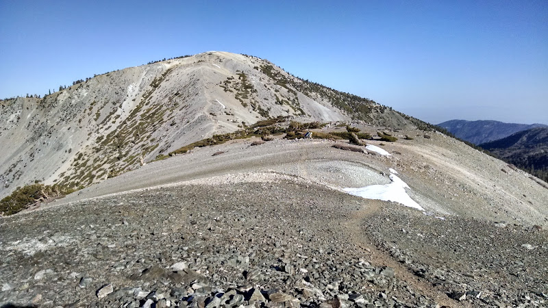
Last section going uphill. I head to the right side, avoiding the ridge (and wind) on the way up. I counted 27 other people in this photo.


Image
Fortunately for me someone else had kicked steps through this massive snowfield.


Image
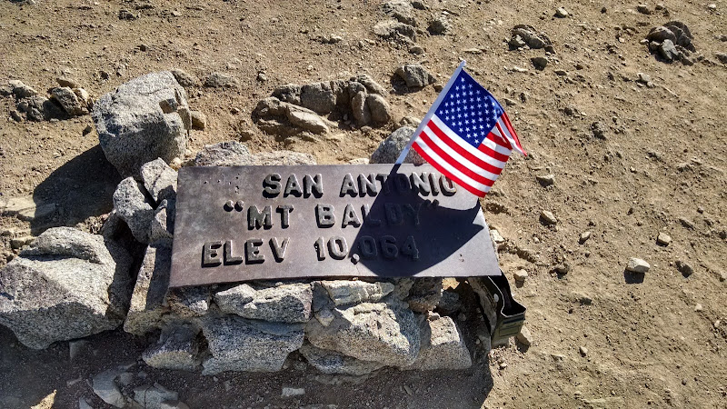
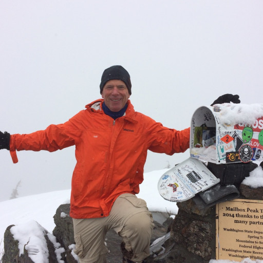
Proof of my visit. I believe it's number 29 for me. First time I've seen a register box too.


Image
Looking back at the other trail. I like to walk out to the edge of the bowl for the views.


Image
I thought I was on the trail and then it turned into this rock-filled gully. And this section has seen some serious erosion over the last couple of years.


Image
Looking back up as I approached the paved San Antonio Falls road.


Image
Stats. Includes breaks and sightseeing.


Still a great day out in the mountains.
"Argue for your limitations and sure enough they're yours".
Donald Shimoda
User avatar
RichardK
Posts: 727
Joined: Sun Sep 30, 2007 12:33 pm

Post by RichardK »

Thanks for the pictures. I do miss Mt. Baldy.
Walking down via the bowl trail was interesting, there are so many different routes it's hard to tell exactly where to walk.
Thoughtless hikers have made numerous shortcuts in that section. They have even been shortcutting the shortcuts resulting in an eroded maze. The last time we were there, we lost the trail going up and had to claw up a steep slope to regain the trail. The forest service needs to make a concerted effort to re-establish the original trail. Maybe even post a ranger on weekends to enforce staying on trail. Of course, it will never happen.
User avatar
psykokid
Posts: 80
Joined: Fri Mar 18, 2016 1:15 am

Post by psykokid »

It was a great day to be up on Baldy. I was up there a bit earlier than you were. I went up to the backbone trail, topped out on Harwood, then side hilled around Baldy away from last bit of switchbacks and made my way to the summit. Had the summit all to myself while I was there, which is a rare occurrence. After that I went west down the ridgeline and back up and found the benchmark for West Baldy. I went back down to the saddle between the two and again side hilled around level until I caught up with the Bowl trail. Once I started down the Bowl trail that's when I started running into traffic on the trail. Started at 5:30 and was back to my truck by 10.

Image

Image

Image

Here's a link to my route on Caltopo : http://caltopo.com/m/G4U1
User avatar
JeffH
Posts: 1169
Joined: Sun Nov 28, 2010 7:09 am

Post by JeffH »

West Baldy is always nice, hardly anyone goes there so it's a chance to get some solitude.
"Argue for your limitations and sure enough they're yours".
Donald Shimoda
User avatar
tekewin
Posts: 1195
Joined: Thu Apr 11, 2013 5:07 pm

Post by tekewin »

Nice trip, JeffH. It is such as classic. I really liked my one visit to West Baldy, too. There are still more routes for me to do so I can't imagine I'll stop going any time soon. Holidays are too crowded for me, though.
User avatar
Sean
Cucamonga
Posts: 3787
Joined: Wed Jul 27, 2011 12:32 pm

Post by Sean »

A register on Baldy? I better get up there before it's gone.

I wonder if those use trails are mostly from winter climbers who blast up the ridge instead of the no-doubt icier west side.
User avatar
SGBob
Posts: 101
Joined: Wed Jan 07, 2015 12:47 pm

Post by SGBob »

RichardK wrote: The forest service needs to make a concerted effort to re-establish the original trail. Maybe even post a ranger on weekends to enforce staying on trail. Of course, it will never happen.
That's because almost every single additional dollar the Angeles gets for staff goes into hiring more people to work at the Arcadia headquarters so they can come up with new and exciting plans and programs they can't implement for lack of field staff. As far as I know there still aren't any paid employees that patrol trails in the Angeles. All trail repair and maintenance is performed by volunteers.
User avatar
JerryN
Posts: 200
Joined: Sun Nov 11, 2012 4:01 pm

Post by JerryN »

Those use trails have been there for some years. It is not the winter hikers, rather the way up is not clear so everyone just takes what seems to make sense. The rain this year eroded them a bit though.

How did you get 5372' of elevation gain on a trail that starts at 6160 and ends at 10050? I don't think there are any significant downhills on the climb up and don't see any detours on your route map.
User avatar
dima
Posts: 1354
Joined: Wed Feb 12, 2014 1:35 am

Post by dima »

JerryN wrote: How did you get 5372' of elevation gain on a trail that starts at 6160 and ends at 10050? I don't think there are any significant downhills on the climb up and don't see any detours on your route map.
The GPS data always has a bit of jitter that needs to be filtered out, but since it's difficult to tell what is a "real" elevation change and what is jitter, the filters are never perfect. The elevation differences could even be real, as observed by the GPS, but aren't "real" in the sense we care about: if the receiver is in your pocket, it moves up/down a bit with every step, which we'd want to ignore. In any case, the filter in whatever JeffH used could probably be tuned better.
User avatar
JerryN
Posts: 200
Joined: Sun Nov 11, 2012 4:01 pm

Post by JerryN »

Dima, I think you are right. I usually wear my gps on my shoulder so that it does not bounce around. If it swings or bounces up and down it can misread.
I thought it might also be a cool side trip that was not shown on the map and if so was wondering where it might be.


BTW: JeffH, I liked your trip report and pictures. Thanks for posting them. Even with all the people on the mountain it is great to be out there.

Jerry
User avatar
JeffH
Posts: 1169
Joined: Sun Nov 28, 2010 7:09 am

Post by JeffH »

I was using Runkeeper on my iPhone. I noted in another discussion that it can be wildly off on elevation, next time I'll try a different app. Somewhere around here I have an old Magellan GPS unit, maybe I can compare with that (if I find it of course).
"Argue for your limitations and sure enough they're yours".
Donald Shimoda
User avatar
JerryN
Posts: 200
Joined: Sun Nov 11, 2012 4:01 pm

Post by JerryN »

Ah, makes total sense.

I think what might have happened with that is the phone app uses a gps reading for your elevation. while it is supposed to peg you within a short distance of where you are at, on steep hillsides it can have you jump up quite a distance and then back down without showing much horizontal distance. There are plenty of those steep hilsides on the route you took.

My wife used hers on a hike we did to Vivian Creek and she got 2,000' on a 1,000' climb. My Garmin uses barometric pressure for the elevation and is not subject to that problem. It has other issues, but not this one.

Jerry
User avatar
RichardK
Posts: 727
Joined: Sun Sep 30, 2007 12:33 pm

Post by RichardK »

JerryN wrote: Those use trails have been there for some years. It is not the winter hikers, rather the way up is not clear so everyone just takes what seems to make sense.
15 years ago the trail was well defined. Then, it was downhill hikers who started routinely cutting switchbacks. More and more use trails appeared. Add to that, the big storm that turned use trails into eroded gullies. You have today's mess.
Post Reply