Hoegees -- Water?
-
Hikin_Jim

- Posts: 4688
- Joined: Thu Sep 27, 2007 9:04 pm
I'm going to do the Mt Wilson Loop from Chantry Flats this weekend. Anyone know if there is water at Hoegees? (or at the trail crossing above Hoegees) I think last I heard it was dry?
HJ
HJ
-
HikeUp

- Posts: 4036
- Joined: Thu Sep 27, 2007 9:21 pm
Gonna be somewhat warmish. I am sure you know about the spigot in the big parking lot at the top (adjacent to the cafe). Hope it is still there and working. It saved me some pain on a loop hike that turned out to be a lot warmer than I had anticipated. Any way - I know nothing about Hoegees status - sorry! Have fun my friend!
-
Hikin_Jim

- Posts: 4688
- Joined: Thu Sep 27, 2007 9:04 pm
Predicted high in Sierra Madre is 82. Doesn't sound too bad, but possibly humid.HikeUp wrote: Gonna be somewhat warmish.
Yeah, the hiker's friend. I'm hoping there will be some kind of water available up top or it'll be a long, heavy carry.HikeUp wrote: I am sure you know about the spigot in the big parking lot at the top (adjacent to the cafe).
HJ
-
HikeUp

- Posts: 4036
- Joined: Thu Sep 27, 2007 9:21 pm
I'd plan on it peaking at 90 for a short time around 2pm.
-
Hikin_Jim

- Posts: 4688
- Joined: Thu Sep 27, 2007 9:04 pm
Temps weren't bad at all. I was a little surprised. I expected upper 80's, but it was low 80's. Now, that was on the Sturtevant Trail which is super shady. Taking a different trail, one more exposed, would be a very different story.HikeUp wrote: I'd plan on it peaking at 90 for a short time around 2pm.
HJ
-
HikeUp

- Posts: 4036
- Joined: Thu Sep 27, 2007 9:21 pm
Cool! Glad it was nice. Warm down here in the city.
-
outwhere

- Posts: 323
- Joined: Sun Jan 25, 2009 5:40 pm
Ain't too proud to beg....
Any photos of your Hoegees camp out ?
Any photos of your Hoegees camp out ?
-
Hikin_Jim

- Posts: 4688
- Joined: Thu Sep 27, 2007 9:04 pm
Here's my post hike update:
There is some water in Santa Anita Canyon, but not a lot. There are major stretches of stream bed that are completely dry, typically sandy or gravelly sections. In those spots where there is exposed bedrock, there is flowing water. Water flow is actually fairly decent at Spruce Grove.
The creek is dry at Hoegees according to hikers I talked to, but supposedly there is water further up Winter Creek per a cabin owner I spoke to. That's where he gets his water, so I imagine he knows what he's talking about.
The faucet atop Mt. Wilson is working; however, there is a sign that says that they haven't done all the required water quality testing. That's not necessarily an indication of a problem, but if one were sensitive about such things, perhaps it is of note.
Here's my GPS track of the Chantry Flat - Mount Wilson Loop. The blue dots are GPS waypoints that represent water.
Waypoint 24 is a small spring on the Winter Creek Trail. It's flowing, but just barely.
Waypoint 25 is San Olene Canyon. No flow, but there was a small pool (really small) just above the trail.
Didn't take a lot of photos, but I'll post some when I have time.
HJ
-
outwhere

- Posts: 323
- Joined: Sun Jan 25, 2009 5:40 pm
Cool Jim, TIA if ya can post some pics...
Like so many other folks here, you post great TR and pics... but when it comes to Hoegees and a camping trip - pictures sound extra cool...
I can see 'em now, the sun setting on your nice camp site, the last light filtering through the trees and the grand finale - the photo of you frying up a 2 pound rib eye over one of your stoves

Silly joking aside, when I used to get up to the hills/mountains, one of my favorite places to camp was Hoegees - go figure, right There's just something about that spot...
Thanks again Jim (and to everyone else that posts TRs and SGM photos)
Like so many other folks here, you post great TR and pics... but when it comes to Hoegees and a camping trip - pictures sound extra cool...
I can see 'em now, the sun setting on your nice camp site, the last light filtering through the trees and the grand finale - the photo of you frying up a 2 pound rib eye over one of your stoves
Silly joking aside, when I used to get up to the hills/mountains, one of my favorite places to camp was Hoegees - go figure, right
Thanks again Jim (and to everyone else that posts TRs and SGM photos)
-
Hikin_Jim

- Posts: 4688
- Joined: Thu Sep 27, 2007 9:04 pm
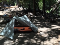
Well, before we go too much further here, I actually camped at Spruce Grove which has much better water (right at the camp site, running well, no having to search far upstream) than Hoegees.
So, for photos:
https://eispiraten.com/viewtopic.php?t=6386
HJ
So, for photos:
https://eispiraten.com/viewtopic.php?t=6386
HJ
-
Hikin_Jim

- Posts: 4688
- Joined: Thu Sep 27, 2007 9:04 pm
UPDATE: I went back out on Friday/Saturday (July 17/18) with my daughter. There is water at the stream crossing above Hoegees and there is water just below Hoegees.
There's a nice pool about 1/4 mile below Hoegees. The water in the pool should last well into August if not all the way into fall.
The water right at Hoegees probably will dry out before then although with the rain we're getting right now, who knows?
HJ
There's a nice pool about 1/4 mile below Hoegees. The water in the pool should last well into August if not all the way into fall.
The water right at Hoegees probably will dry out before then although with the rain we're getting right now, who knows?
HJ
-
PeteJE

- Posts: 8
- Joined: Mon Aug 10, 2015 2:05 am
Was at Hoegees Aug 2/3 - there was collectable water, although a trickle. Enough flow to get some good running off a couple rock falls into my small swayer filter squeeze bag. It was accessible right at the campsite, farther south there were dry sections where it must disappear to an underground flow here and there. We had some pretty persistent bear activity - bear cans are a must for now there, imo. See my report on this thread:
https://eispiraten.com/ftopic6386-10.php
https://eispiraten.com/ftopic6386-10.php
-
EBruddah

- Posts: 20
- Joined: Thu Aug 20, 2015 4:38 pm
If you want to know current trail/water conditions in Chantry Flats near Hoagee's or Spruce shoot an email to Deb or call her at the pack station.
http://adamspackstation.com/
http://adamspackstation.com/
-
hillbasher
- Posts: 61
- Joined: Thu Sep 27, 2007 8:58 pm
Talked to both the rangers and the pack station at Chantry on Saturday,October 31st. Both said that Winter Creek was flowing nicely at Hoegees and water was not an issue.
