Kelly Camp Spring
-
RichardK

- Posts: 727
- Joined: Sun Sep 30, 2007 12:33 pm
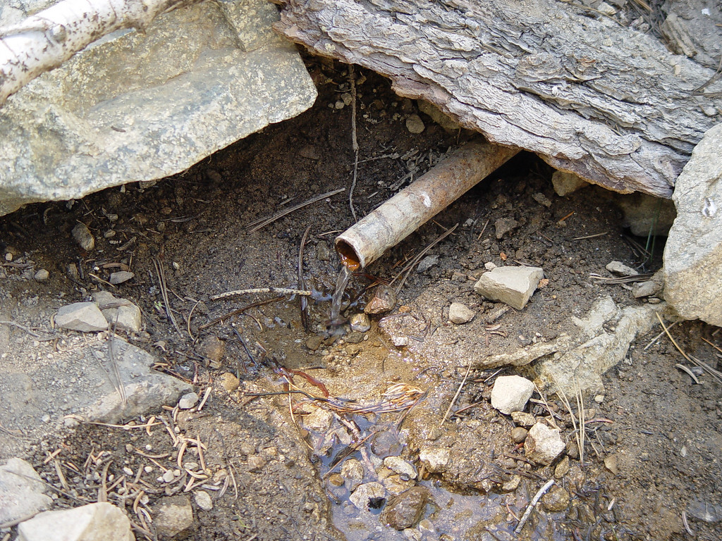
We hiked Ontario yesterday. The heat was not bad until 1:00PM, but we were on the descent by then. We could see the SAR copter orbiting the Ski Hut. The Kelly Camp Spring was flowing, but low. Here is a picture:


-
Mike P

- Posts: 1005
- Joined: Tue Oct 02, 2007 10:48 pm
If you hike further downhill (~200-300 ft) from the pipe "spring" there is usually good water.
-
Hikin_Jim

- Posts: 4688
- Joined: Thu Sep 27, 2007 9:04 pm
Richard (and Mike):
How reliable have you guys found that water to be? I kind of think of it as maybe good through mid-July (??), but I don't get out there enough to have a good feel for it. Do you guys have a good sense of it's reliability?
And you're talking about the gully just west of the camp, yes? (see point "A" in the map link) Not the the intermittent stream maybe .25 to .3 miles east of the camp? (Point "B"). I didn't even know there was an actual pipe. I've always just looked for the wet stuff, silly me.
http://mapper.acme.com/?ll=34.23418,-11 ... Baldy%20CA
Thanks for the 411 in advance!!
HJ
-
RichardK

- Posts: 727
- Joined: Sun Sep 30, 2007 12:33 pm
Hi Jim,
I think you got points A and B reversed on your map. The picture was taken at the map's point B maybe 200 or 300 feet west of the bend in the trail at Kelly's. If you walk across the camp westerly away from the trail, you will see a grassy area. A faint use trail leads to the pipe. I have not looked downhill from the pipe to see what is there. I have never seen water at the intermittent stream marked in Delker Canyon as point A. We hike Ontario 2 or 3 times a year about this time. Last year, a dry year, the pipe still had water, but literally one slow drop at a time. I can't speak about late July or August, but the flow is low enough I would not want to depend on it. On the other hand, Columbine Spring always has a decent flow, even in drought years.
Regards,
Richard
-
Hikin_Jim

- Posts: 4688
- Joined: Thu Sep 27, 2007 9:04 pm
Hi, Richard,
Yes, you're right I reversed the "A" and the "B," but I'm glad that you picked up what I meant.
Thanks for the info; that's about what I was thinking in terms of water reliability. Thanks for the 411.
Yes the water at Columbine is pretty rock solid. Not only does it flow in dry years, it flows well. A really neat spring, and, as it name suggests, often there are beautiful red columbines. I'm always amazed at just how steady this spring is.
If you go back to the map and zoom out a bit, you'll see that I also marked points "C" (Columbine Spring) and "D." "D" is in a canyon which is a tributary to the Middle Fork of Lytle Creek. Sometimes there's water available further up the trail towards Icehouse Saddle than point "D," but not always. However, at point "D" or shortly downstream from "D," the water is pretty rock solid. This is a nice area that isn't as heavily travelled as Icehouse Canyon but well worth visiting. Most people go up Icehouse Can to either the saddle, to the right to Ontario, Big Horn, or Cucamonga or left to Timber or the "Three T's," but not many go straight and descend to the tributary where "D" is, so "D" can be a nice option on a crowded day. You can also come up from the Lytle Creek side. There are some wash outs (three, one quite "airy"), but all are passable.
Cedar Glen Trail Camp on the Chapman Trail (the upper trail in Icehouse Canyon) has also surprised me on occasion by having water even fairly late in the season.
All in all, a neat area to hike!
HJ
Yes, you're right
Thanks for the info; that's about what I was thinking in terms of water reliability. Thanks for the 411.
Yes the water at Columbine is pretty rock solid. Not only does it flow in dry years, it flows well. A really neat spring, and, as it name suggests, often there are beautiful red columbines. I'm always amazed at just how steady this spring is.
If you go back to the map and zoom out a bit, you'll see that I also marked points "C" (Columbine Spring) and "D." "D" is in a canyon which is a tributary to the Middle Fork of Lytle Creek. Sometimes there's water available further up the trail towards Icehouse Saddle than point "D," but not always. However, at point "D" or shortly downstream from "D," the water is pretty rock solid. This is a nice area that isn't as heavily travelled as Icehouse Canyon but well worth visiting. Most people go up Icehouse Can to either the saddle, to the right to Ontario, Big Horn, or Cucamonga or left to Timber or the "Three T's," but not many go straight and descend to the tributary where "D" is, so "D" can be a nice option on a crowded day. You can also come up from the Lytle Creek side. There are some wash outs (three, one quite "airy"), but all are passable.
Cedar Glen Trail Camp on the Chapman Trail (the upper trail in Icehouse Canyon) has also surprised me on occasion by having water even fairly late in the season.
All in all, a neat area to hike!
HJ
-
FIGHT ON
Think I'd rather carry my own water. If it was a copper pipe I might try it but no way that pipe. Did you drink out of it?
-
Taco

- Snownado survivor
- Posts: 6136
- Joined: Thu Sep 27, 2007 4:35 pm
Not sure if this helps or anything, but last time I drank from a spring was in Falling Rock Canyon, in Icehouse Canyon. Was mildly and strangely sick for a week afterwards, which screwed me up in the Sierra. Strong nauseau was the worst symptom, no throwing up. I think I've had some Columbine Spring water before with no ill-effect.
-
RichardK

- Posts: 727
- Joined: Sun Sep 30, 2007 12:33 pm
We have been drinking from Columbine for years without any bad effect. The water there comes directly out of granite. However, the pipe does not look very inviting and, by refilling at Columbine going up and coming down, we didn't need the water anyway. If I were going to drink from the pipe, I think I might add some iodine first. I assume that the pipe is a leftover from when Kelly's was a pack station.
-
135driver

- Posts: 49
- Joined: Fri Nov 09, 2007 6:43 pm
Iodine is a beatuful thing. I drank stagnant pooled water in the mountains in washington. Put some iodine in it, with no ill aftereffects, and it didn't really taste that bad. You can also use chlorine bleach (just regular, not scented) and add about 2-3 drops per quart, maybe 4 if it's dirty water. Shake it up and wait about 30 mins. before drinking.
Yum Yum
Yum Yum
-
Hikin_Jim

- Posts: 4688
- Joined: Thu Sep 27, 2007 9:04 pm
Went up Ontario Pk yesterday. Nice hike but a bit hot. Kelly Camp spring was most welcome. I actually found two pipes in that area, neither of which looked exactly like the pipe in the picture. One of the pipes I saw looked similar to the photo. Someone could have moved that piece of bark and/or the rocks. Anyway, both pipes were flowing about as shown in the picture.
The flow is a little low, but I took a wide mouthed bladder along and used that to gather water. I put the bladder over the end of the pipe and let gravity fill the bladder while I was snacking. Very nice tasting water by the way.
The flow is a little low, but I took a wide mouthed bladder along and used that to gather water. I put the bladder over the end of the pipe and let gravity fill the bladder while I was snacking. Very nice tasting water by the way.
