

http://www.everytrail.com/view_trip.php?trip_id=2207403
https://picasaweb.google.com/1002780459 ... /20130707#
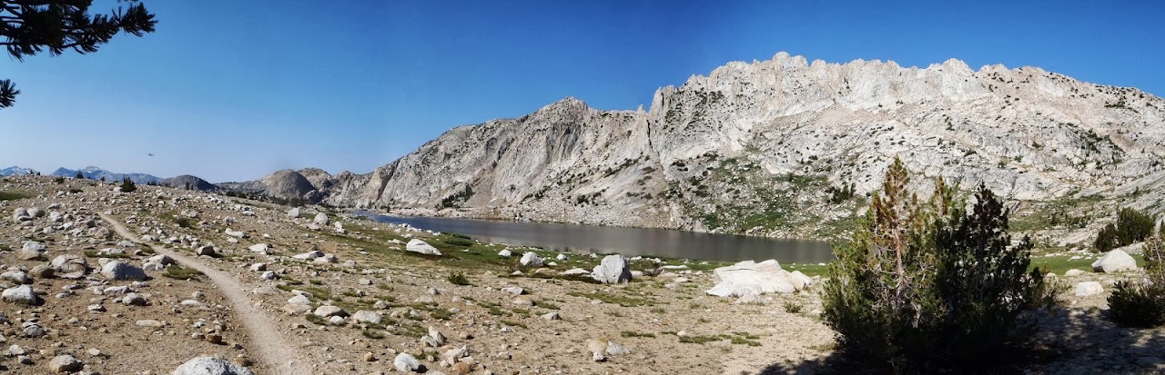
Silver Pass Lake
Chief Lake


This trip closed the last gap in my PCT "Segment" hike for Section H. Leaving Sections I, L, & M (209.4 miles) to complete Central California
My friends and I did a "Key exchange" for this trip as the drive from Reds Meadow to VVR is about 7hrs according to Google Maps.
This segment is logistically difficult for the Section hiker since it crosses from the Western Sierra to the Eastern Sierra. Making the choice of starting and ending trailheads difficult with epic shuttles.
July 3rd
I arrived at Vermillion Valley Resort about 3pm and got a ferry ride in a small boat to the other end of the lake.Starting to hike at 5pm. I made for the camp I knew of from a traditional rock work skills training I joined in 2006 3.9 miles from the end of the ferry ride.
When I got to the camp I marveled considering the number of people (20+) who used this camp for more than a month it is remarkable there is little evidence of it's use.
July 4th
Got moving at 5:45am. I was eager to see how the work we did fared since 8/2006 and was greeted with a well built segment of trail at the crossing of Silver Pass Creek. The only thing that didn't hold up was the stepping stones across the creek!
The trip to Silver Pass was easier than I thought. Looking back south you can see what I think was Recess Peak. At Silver Lake looking north you see what appears to be Silver Pass but is a false pass the real pass a couple hundred feet higher and a bit to the right.
I pushed on through the pass past Chief and Squaw lakes with Silver Divide as a breathtaking backdrop.
Down to Cascade Valley and the well built stock bridge over Fish Crk I stopped for lunch along the roaring crk.
Got going about 1pm heading for Virginia Lake going through Tully Hole.
There is no "hole" here
Crossed an unnamed pass and dropped to Virginia Lake. The wind is strong here and despite waiting an hour or two it showed no signs of dissipating. So I filled my water bottles and headed north.
I came to another unnamed pass with little wind and good shelter from any. I made camp here. I read 15.68 miles on the GPS. No lightning just some diminishing thunder for my July 4th fireworks
An InReach message said I should meet my friends about 1pm tomorrow
July 5th
Got going about 5:50am heading for rendezvous with my friends. It was a bit further to Purple Lake than I expected. As you may have guessed it is not Purple, Violet nor any other shade of Purple! It is a nice place though a little buggy.
I noted many backpackers where camped at the edge of the lake. Despite permit restrictions.
I pressed on and stopped for a break about 10am. I noted a message on the InReach the rendezvous is off. they are going ti Ivy Bell Hot Springs? I reply "Huh so now what?", they reply "the truck is in C parking" I reply "Ok I'm exiting today see you on Saturday ? "
The take away after reaching the truck there was a note that they where "Detouring to the hot springs" I'm still a bit confused but after considering it they would have said "DO NOT LEAVE WE ARE COMING BACK HERE"
I include this to point out the InReach is great but you need to consider the message in BOTH directions. Much was left unsaid on both ends.
I took a long break at Deer Creek and headed for Reds Meadow. I noted the map is not very accurate in places and the trail crosses many creeks over small footbridges and several springs.
As I was coming into Reds Meadow I saw the SoCal PCTA "Trail Gorillas" where here. I waited for 2hrs but my friends Pete and Jerry where late in coming and I was hungry and anxious as to whether I was going to have to wait or leave. My right Index Toe the nail was messed up and nearly coming off , and wanted to tend to it.
