Pine Mountain Ridge - 6/22/2013

TRs for the San Gabriel Mountains.
Post Reply
User avatar
mcphersonm80
Posts: 243
Joined: Mon Aug 23, 2010 11:46 am

Post by mcphersonm80 »

For years I've been obsessed with Pine Mountain Ridge as seen from the summit of Baden-Powell. Finally got around to hiking it on Saturday.

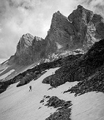
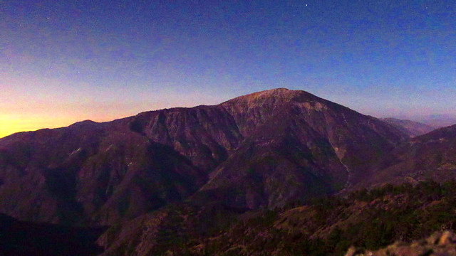
We drove up to Vincent Gap and hit the trail about 8:15am (given the full/supermoon thing, we intended to be out long after dark). Pine Mountain had that blue tint that mountains have when they're really far away... this is gonna be a long day. :?

Image
Pine Mountain from Vincent Gap

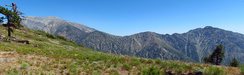
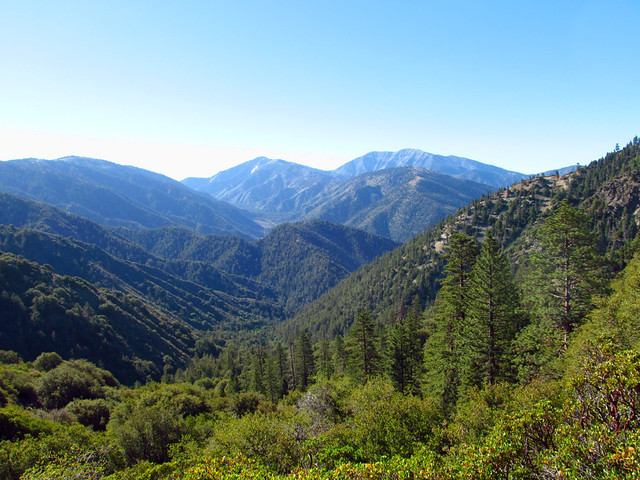
Despite this being one of my favorite areas in the range, I had never been down the Mine Gulch Trail. Its an absolutely gorgeous stretch of trail, and pretty easy all the way down to the river, too. We flew down this stretch in no time, ejoying the gentle slope knowing the tough part was ahead. Came across the plane wreck and some nice spots along the Prairie Fork with views opening up to Baden-Powell above.

Image
Glider Wreck from 1974

Image
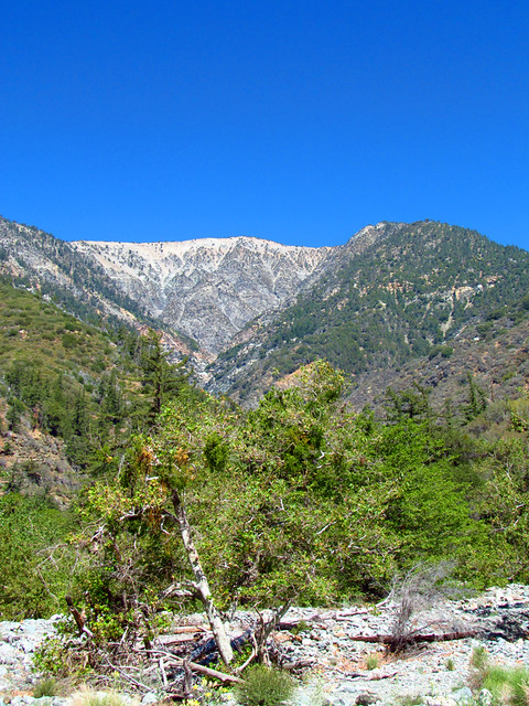
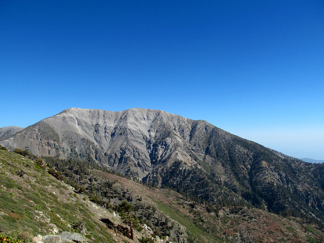
Mt Baden-Powell above Mine Gulch

If you're not experienced in cross country, bushwacking, route finding, etc., stop reading, turn around, and head back to Vincent Gap. :shock:

One of the toughest parts of Pine Mountain Ridge is getting on the damn thing. Where it meets the East Fork, the entire ridge is covered in an impenetrable wall of whitethorn/ceanothus, probably the last plant you'd want to bushwack through. The brush was often times several feet taller than us, and at times we found ourselves crawling on all fours around huge piles of bear scat to get through it.

Image
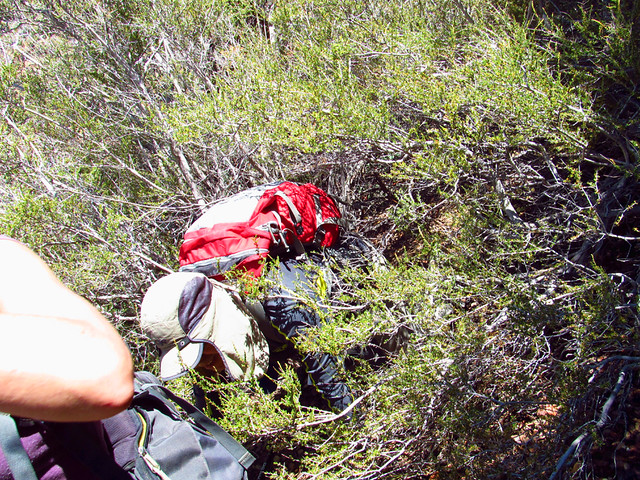
Crawling through Knives

Image
You can sort of see me in there...

The initial climb from the river to about the 5000' level is some of the thickest brush I've ever encountered. Kind of goes without saying, our paced dropped to a point where we were envying snails, and it really wouldn't pick up much until we reached Pine Mt.

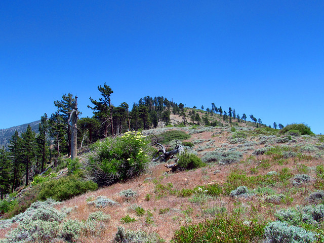
Eventually, once we finally gained the ridge proper, the brush loosened up slightly. It was still pretty horrible, but nothing like that first part. And the views from up here are absolutely incredible, wildflowers everywhere and the surrounding peaks becoming more and more grand.

Image
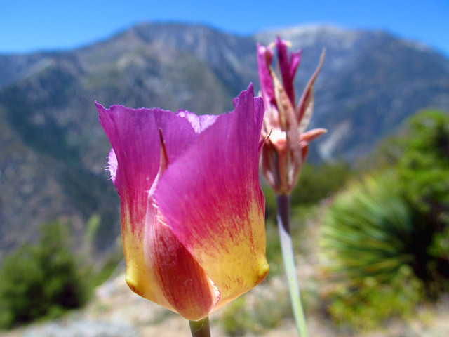
Plummers Mariposa Lily

Image
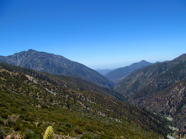
Iron Mountain and Rattlesnake Peak above the East Fork

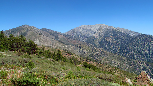
There were a few stretches that were free of whitethorn and manzanita, but they still had that spiky grass that get stuck in your shoes and socks. There is a decent stretch that used to have some kind of jeep road or something. It's fairly easy walking here. Baldy also starts coming in to view here; it can't really be captured in pictures how massive it is from this side.

Image
The "Easy" Part

Image
Getting Closer

Image
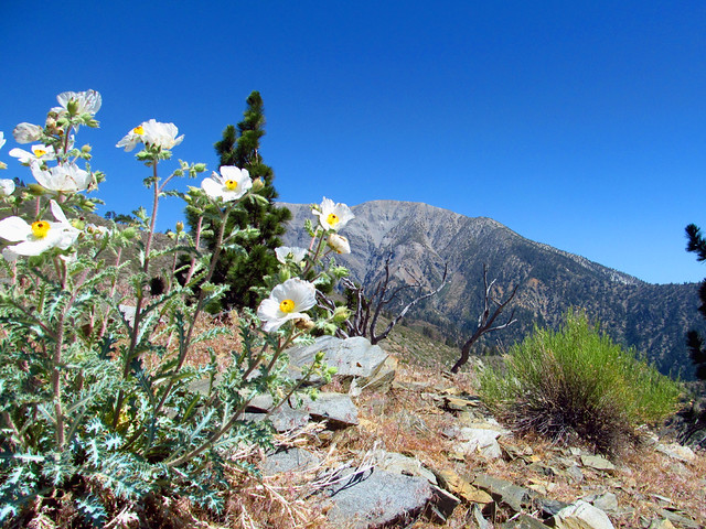
Matilija Poppies on Pine Mountain Ridge

There's one knife edge ridge as you approach the final couple steps that's particularly unnerving. It's tilted slate, probably about a 20 yard stretch, slippery and crumbly with only a couple inches to work with. A fall to the right would land you a couple hundred feet down in thick brush, and a fall to the left would get the job done quicker.
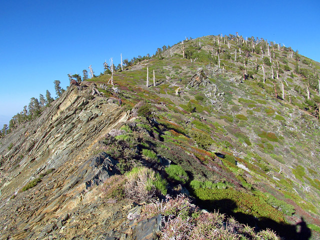
 :shock:

Image
Knife Edge Bit

Image
Baldy from Pine's West Slope

Past this, it's more of the same. Nothing easy about it, but extremely rewarding and an incredible relief when you get to the top.
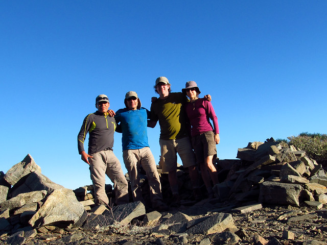
Image
Summit Shot

Back on familiar ground, we took a nice break at the top and made sure to get down the sketchy parts of the North Backbone Trail before sundown. We timed it perfectly and had some incredible views of the sunset and the full moon rising.

Image
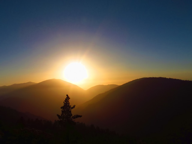
Setting Sun over Baden-Powell
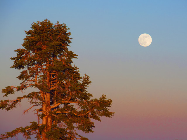
Image
Supermoon Rising

Image
Mt Baden-Powell illuminated by the full moon, with the glow of LA on the left. (10-second exposure)

From the North Backbone, it was a leisurely 10.5 mile stroll down Blue Ridge Rd and Highway 2 back to Vincent Gap (car shuttles are cheating :wink: )

Image

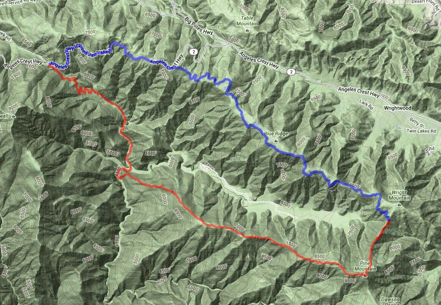
Disclaimer: All in all, this hike totaled 22 miles with 6000'+ of gain. I carried 6 liters of water and drank all but about 8oz. If I did this again, I'd carry more. All four of us are experienced hikers and it took us 16.5 hours to complete this loop. Due to the brush and obstacles encountered, we averaged less than 1mph on the ridge itself. I would say without hesitation that this hike is much more difficult than Iron Mountain from Heaton Flat. Do not attempt this route unless you're absolutely certain of your abilities.

More photos here: http://www.flickr.com/photos/wattifoto/ ... 300207320/

Cheers :D
User avatar
cougarmagic
Posts: 1409
Joined: Wed May 07, 2008 5:21 pm

Post by cougarmagic »

Bravo! I've wanted to explore the ridge for a long time, too. I thought there might be some kind of use trail, but now thanks to your hard work I don't have to find out the hard way! Not surprised at the brush on the ridge down near the canyon bottom, but I really thought up along the main ridge would be more open, pine forest.

Good to know the bears are happy there!

Cool pics.
User avatar
Uncle Rico
Posts: 1402
Joined: Thu Mar 20, 2008 7:48 pm

Post by Uncle Rico »

Hard core dude. Excellent pics.
User avatar
Taco
Snownado survivor
Posts: 6010
Joined: Thu Sep 27, 2007 4:35 pm

Post by Taco »

Great pics dude. 8)
User avatar
Sean
Cucamonga
Posts: 3787
Joined: Wed Jul 27, 2011 12:32 pm

Post by Sean »

Congrats on conquering your obsession. Now you'll have to develop another one.
User avatar
AW~
Posts: 2043
Joined: Mon Oct 01, 2007 12:00 pm

Post by AW~ »

Totally cool....such a pretty area.
User avatar
tekewin
Posts: 1195
Joined: Thu Apr 11, 2013 5:07 pm

Post by tekewin »

Great report and awesome pictures.

The bushwhacking at the start of the ridge looks like a real buzz kill. Must have taken some real determination.
User avatar
cougarmagic
Posts: 1409
Joined: Wed May 07, 2008 5:21 pm

Post by cougarmagic »

Hey by the way - is the road down to Lupine camp still closed? Any sign of them working on repairing it? (I know Blue Ridge is open, I mean the last 3 miles going down from the ridge, right to the camp).
User avatar
JDB22
Posts: 54
Joined: Fri Feb 17, 2012 9:44 am

Post by JDB22 »

Outstanding photographs & a fun read sitting here comfortably at my computer, not bushwhacking through that madness. The Mariposa Lily photo was really nice.
User avatar
mcphersonm80
Posts: 243
Joined: Mon Aug 23, 2010 11:46 am

Post by mcphersonm80 »

Thanks for the compliments, everyone. :D
cougarmagic wrote:I thought there might be some kind of use trail, but now thanks to your hard work I don't have to find out the hard way!
We thought there would be too, but nope. A couple game trails here and there, but overall you're completely on your own on the ridge.

Sean wrote: Congrats on conquering your obsession. Now you'll have to develop another one.
Already floating some ideas around :wink:

cougarmagic wrote: Hey by the way - is the road down to Lupine camp still closed? Any sign of them working on repairing it? (I know Blue Ridge is open, I mean the last 3 miles going down from the ridge, right to the camp).
Actually, Blue Ridge Rd was only open up to Guffy, which kind of surprised us. The gate on the Lupine turn-off was also closed, obviously, and I didn't see any sign of them fixing it up. It does seem like they've done quite a bit of work on the road as far as Guffy though, it was in much better shape than the last time we drove up to the North Backbone trailhead. Hopefully they'll continue that and get the Lupine Rd opened up again eventually.
User avatar
mcphersonm80
Posts: 243
Joined: Mon Aug 23, 2010 11:46 am

Post by mcphersonm80 »

roseonline wrote: Get the best Shoes For Crews coupons online only on ShoppingSpout.com
Where were you a couple days ago?! I really could have used Shoes for Crews on this hike! :x
User avatar
mcphersonm80
Posts: 243
Joined: Mon Aug 23, 2010 11:46 am

Post by mcphersonm80 »

One more photo you guys might be interested in:

San Antonio Ridge

Image

Click Here for the Giant Version
User avatar
missy
Posts: 83
Joined: Thu Jul 31, 2014 2:14 am

Post by missy »

Geez your photography is super amazing! I can't wait to redo this area in the spring. Such an awesome trek you did there!
User avatar
RichardK
Posts: 727
Joined: Sun Sep 30, 2007 12:33 pm

Post by RichardK »

Sweet! Really sweet!!
Post Reply