
Figured I'd check out the Goat / Ridge Trail out of Chantry today. I've never been in this area before.
The ridge trail is steep but very follow-able. Made my way to the San Olene Fire Road and then the water catch saucer. Explore the area a bit... weird reflector thing (what is that?), communication antennae, and bee boxes (some buzzing).
Made my way up Santa Anita Ridge via Goat Trail #2. Nice views of Little and Big Santa Anita. On the ridge I could make out The Old Mt Wilson Trail and the heliport.
Climbed the second "hump" and the view was even better. Could make out the bench area on top of Manzanita Ridge and the connector trail to the toll road.
Had to turn back because the sun was going down and I wanted to get off the ridge and run back down the fire road. Didn't see much of the fire road since it was now dark. Clicked on my headlap and had a nice little run back down to Chantry.
Quick question for you all ---- Can one make to to Wilson from Santa Anita Ridge? Anyone ever done that?
Photos?
https://www.facebook.com/media/set/?set ... 086&type=1
Happy Trails!
San Olene Goat Trail to Santa Anita Ridge and beyond?
-
Hiker Phil

- Posts: 13
- Joined: Mon Jan 21, 2013 4:55 pm
You can definitely get to Mt Wilson from the ridge. We did it last Nov. Just follow the ridge it will take you to the bench. From there you can continue up to the top of Mt Wilson.
-
shreddy

- Posts: 241
- Joined: Sun Jan 16, 2011 10:40 pm
Thanks for responding Hiker Phil.
Leaving the hill I stopped in Sierra Madre for a nice ale to enjoy later (it's dusted) The clerk (who is a local) said it was long and I had to "drop down"
Any more advice. Do I need any special equipment other than my smarts, hydration and a good pair of trail/running shoes?
Much appreciated.
That's great Hiker Phil --- any more suggestions / things to look out for? Any idea of mileage from that point to the bench?Hiker Phil wrote: You can definitely get to Mt Wilson from the ridge. We did it last Nov. Just follow the ridge it will take you to the bench. From there you can continue up to the top of Mt Wilson.
Leaving the hill I stopped in Sierra Madre for a nice ale to enjoy later (it's dusted) The clerk (who is a local) said it was long and I had to "drop down"
Any more advice. Do I need any special equipment other than my smarts, hydration and a good pair of trail/running shoes?
Much appreciated.
-
HikeUp

- Posts: 4070
- Joined: Thu Sep 27, 2007 9:21 pm
The part of the ridge that connects to Upper Winter Creek Trail just east of the bench is a roller coaster ride on a fairly well established use trail. Just stay on the ridge and you can't get lost. Unless you are in a white out you should be able to navigate easily.
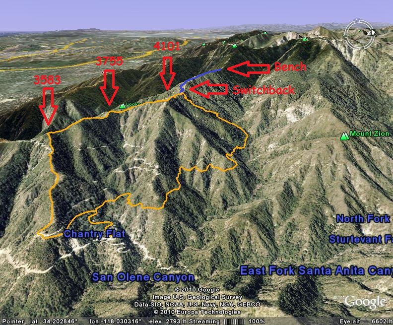
Here is a view of a loop hike that starts at Chantry and takes the Upper Winter Creek Trail to Manzanita (Santa Anita) Ridge, then follows it down to where it crosses the fire road on the way down to the heliport just up the road from Chantry.

Here is a view of a loop hike that starts at Chantry and takes the Upper Winter Creek Trail to Manzanita (Santa Anita) Ridge, then follows it down to where it crosses the fire road on the way down to the heliport just up the road from Chantry.
-
shreddy
- Posts: 241
- Joined: Sun Jan 16, 2011 10:40 pm
Hike Up --- Awesome. Thanks. Definitely will give this a go!
-
Sean

- Cucamonga
- Posts: 4289
- Joined: Wed Jul 27, 2011 12:32 pm
The Goat Trail from Chantry Heliport to Summit 3583 is approximately 0.8 miles with 1100' of gain.
The following are cumulative numbers for the Santa Anita Ridge trail, starting from the San Olene FR near the water tank:
TO:
Summit 3583 - 0.2 miles, 225' gain
Summit 3755 - 0.7 miles, 500' gain
Summit 4101 - 1.1 miles, 875' gain
Winter Creek Connector - 1.5 miles, 925' gain
Manzanita Ridge/Bench Junction - 2.3 miles, 1475' gain
After you descend a little westward from Summit 4101, you go over another smaller bump (3973), then there is what I call the "Winter Creek Connector" trail on the right, which goes a very short distance and connects with the Manzanita Trail. If you want to stay on the ridge, don't take this connector trail, continue straight. You'll almost immediately encounter an extremely steep and loose section of the ridge. There is an overgrown switchback that takes you to the left, avoiding the bad section. After that the remaining ridge route is easy, but parts of the trail are heavily overgrown. Long pants are a good idea unless you're like me and don't mind getting scratched up.
-
shreddy
- Posts: 241
- Joined: Sun Jan 16, 2011 10:40 pm
Thanks for the additional info Sean. Much appreciated. The info about the WC connector option and heads up about the loose area is helpful.
You say loose and unstable section - Is this like" loose and unstable if I fall I'm a dead man?" :O
Will probably head up early Sunday and do a loop / heading back via Winter Creek.
You say loose and unstable section - Is this like" loose and unstable if I fall I'm a dead man?" :O
Will probably head up early Sunday and do a loop / heading back via Winter Creek.
-
Sean
- Cucamonga
- Posts: 4289
- Joined: Wed Jul 27, 2011 12:32 pm
No, nothing life-threatening, unless you bomb down it on a mountain bike and somersault over the handlebars. For a hiker it might be a real hassle to scramble up it, and maybe you'll scrape your hands/knees if you slip. I've always taken the switchback 'cause it's there.shreddy wrote: You say loose and unstable section - Is this like" loose and unstable if I fall I'm a dead man?"
I edited Hikeup's map and added some markers. Also, it looks like Hikeup used the Winter Creek Connection, so I included the rest of the ridge route in blue.
Enjoy your hike. Let me know if the abandoned tent with all the tobacco tins is still up there. Haven't done the full ridge since August. The tent was somewhere between the switchback and the bench.
-
shreddy
- Posts: 241
- Joined: Sun Jan 16, 2011 10:40 pm
Great - Thanks Sean for all the info. Map is very helpful! I'll let you all know how it goes.
-
PackerGreg

- Posts: 623
- Joined: Sat Sep 12, 2009 9:31 pm
The weird reflector thing is a radio repeater for police, fire, FS etc.
-
shreddy
- Posts: 241
- Joined: Sun Jan 16, 2011 10:40 pm
Sean - I happened on one tobacco tin / Scoal. This was well before the switchback / just before a steep short climb where a large rock formation is to your left. No tent either.
Looks like Mt Bikers like some of the upper ridge. Noticed what looked to be little jump mounts made. Some "snow" on the trail. Found the Winter Creek connector. Went to the bench.
Wore running shorts with sleeves. Switchback was easily passable. Looks like this trail gets a fair amount of use. Will now check for tics.
Was planning on the Winter Creek return but lost a cap on the way up. Cap has sentimental value so I did an out and back. Found it!
Very cool / fun scramble! Sean and ALL your descriptions and maps were very helpful! Thank you.
Happy Trails!!!
-
fortified
- Posts: 105
- Joined: Sat Mar 02, 2013 10:03 pm
I "discovered" the Manzanita ridge when I was 17, and just recently found it again. Let me tell you, Late August, late afternoon, 95 degrees, at 56 years old, it is good work out. Somehow this short cut took me longer than the Upper Winter Creak trail.
HOT, NO SHADE, AND NO STOPPING, because their is one long continuous colony of red ants all the way to the WCT connector on Manzanita ridge. Something weird I noticed. All if the large, main red ant holes were almost exactly in the middle of a clearing on each plateau. This can't be a coincidence.
QUESTION: does anyone have any info about red ants and the preceding?
QUESTION: HOW CLOSE TO 8:00 p.m. do they close the exit side of the road. I ran hard down the WCT to get through the gate in time. And besides, I get that creepy "Must be a bear around here" feeling on the dark backside after sunset.
-
Sean
- Cucamonga
- Posts: 4289
- Joined: Wed Jul 27, 2011 12:32 pm
I bet there are dozens of fire ant colonies on that ridge, perhaps competing for the same resources.
By now the more successful colonies have depleted the nearby food sources, and that's why areas surrounding the main holes are clear.
By now the more successful colonies have depleted the nearby food sources, and that's why areas surrounding the main holes are clear.