
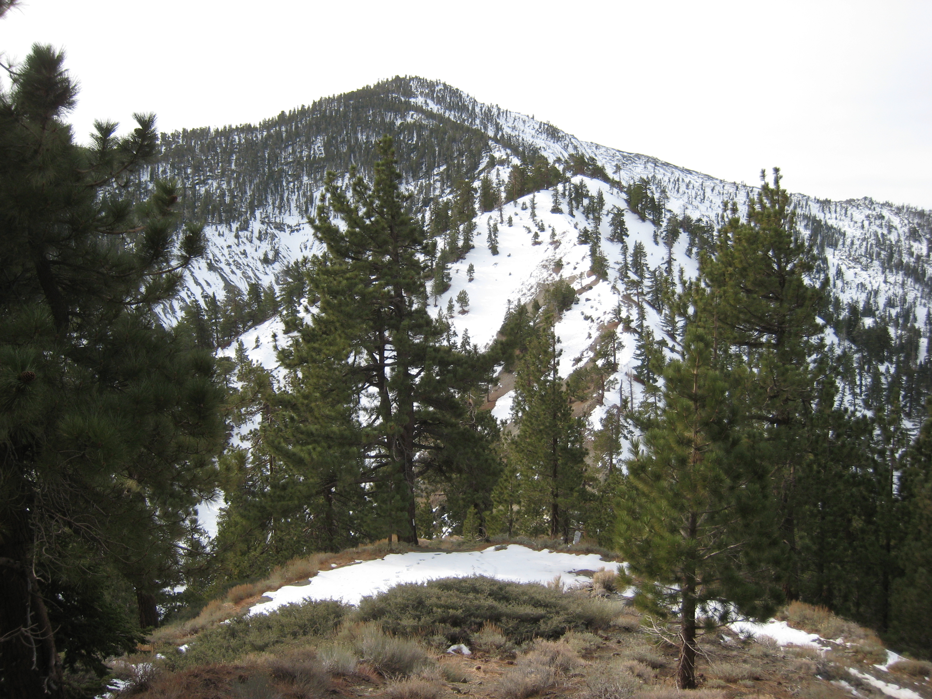
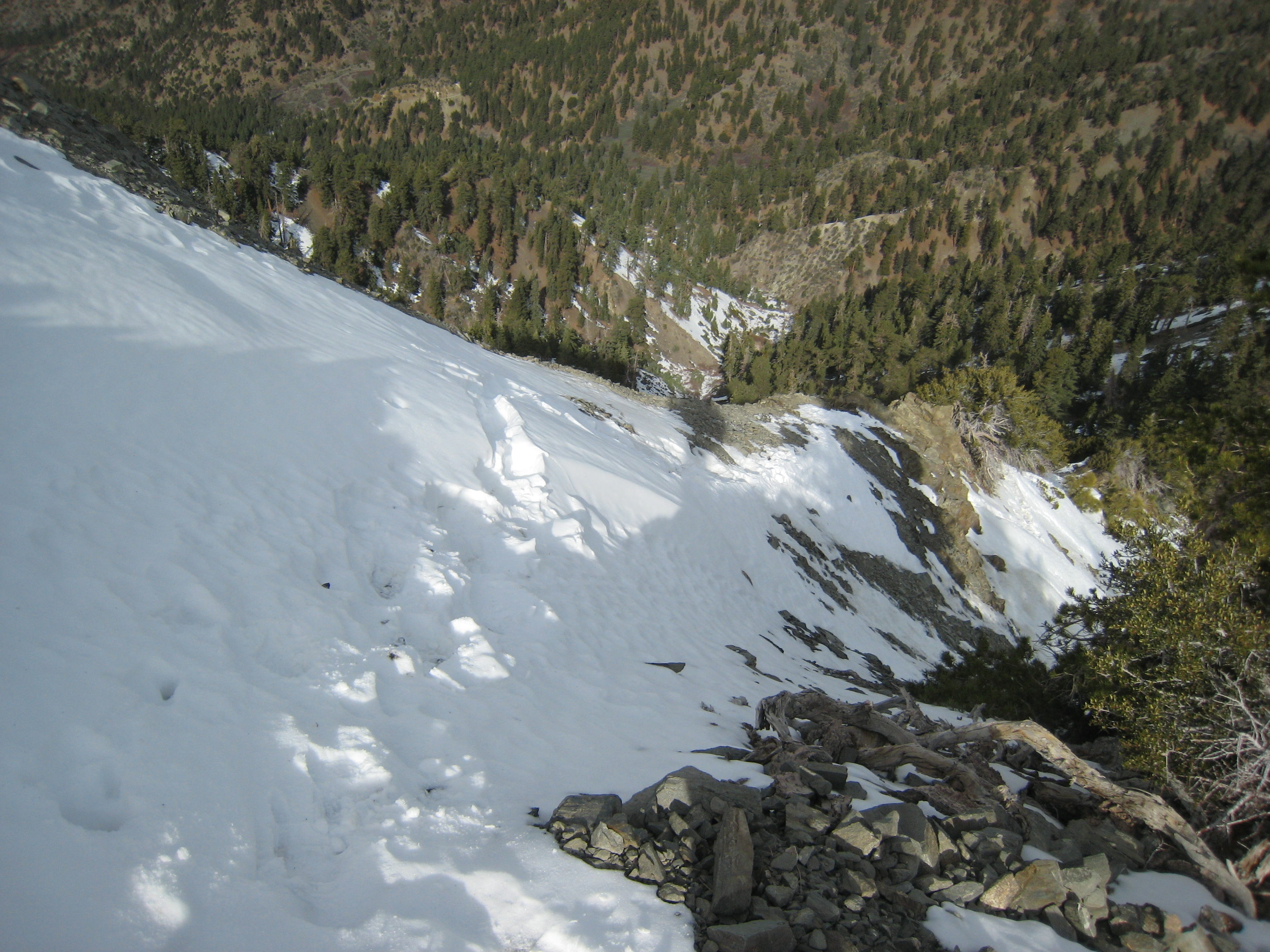
I've hiked Acorn to Wright Mtn, but haven't gone further. Yesterday, a buddy and I decided to knock off a few more peaks. We left LA around 5:00AM, and were parked in Wrightwood by 6:50AM. We were on the move on Acorn Dr. by 7:00AM. The climb to the Blue Ridge Truck Trail (8,280') was typical. Just a bunch of switchbacks, while gaining just under 2,000'. We then proceeded east along the BRTT to the junction of the trail to Pine...Dawson..etc. The wind was blowing at around 20-30mpg on the ridge. The fist bit of this section was fine. However, the final STEEP face up to the top of Pine Mtn was really quite surprising. It was very steep, and composed of very soft soil (little purchase) and decomposing granite. You could trust no foothold. The penalty for a slip or stumble would have been extreme injury or death. ?? There was just no possible way this was a standard recreational "hiking trail" ?? In winter, if any ice, there would be no way without being roped. Has something happened to this portion of the trail? I've only read that it's "an easy climb to Pine Mtn". It most certainly is not for a section of perhaps 300-400' vertical on the north side of Pine. Perhaps someone can shed some light on this?
Once on Pine (9,648'), we took a bunch of pictures. It was an interesting scene because of the solid sea of clouds that were covering the entire SGV and all the way out to Gorgonio and the Big Bear area. Only the 8,000' peaks were visible above the ocean of white. Iron Mtn had only the top 100' or so peaking out. That would have been a really need place to be yesterday. We then continued on.... down and back up to Dawson Pk (9,575').
At this point, we had to decide if we would continue up to Baldy (another ~ 2,000' vertical for the out and back). My buddy decided he'd go. I grabbed a beer and took a nap on Dawson.
On the way back, we had to fire up the headlamps for most of the Acorn Trail. We got back to the car at about 7:00PM...and our way over to the Raccoon Saloon to catch the second half of the Steelers - Bengals game.
Tried to post some pics; but, I kept getting an error. Max upload size?
Acorn Trail-Wright Mtn-Pine Mtn-Dawson-Baldy... and back
-
HikeUp

- Posts: 4071
- Joined: Thu Sep 27, 2007 9:21 pm
The approach to Pine from the north has been that way ever since I first hiked it around 1990. At worst it is 2nd class (need hands for balance), but one spot Is I must admit getting worse and may indeed be called 2nd class with exposure. That is to say, the footing has become less secure in that spot.
Also, the use trail is getting less aand less defined because more and more people are using the trail which means more and more cutting of the switchbacks is occuring. My last timme up there this past summer I witnessed several trail runners scree surfing down that part of the trail and send scree slides in all directions. Grrrrr.
Also, the use trail is getting less aand less defined because more and more people are using the trail which means more and more cutting of the switchbacks is occuring. My last timme up there this past summer I witnessed several trail runners scree surfing down that part of the trail and send scree slides in all directions. Grrrrr.
-
BrownMtnBob

- Posts: 96
- Joined: Mon Oct 15, 2012 1:55 pm
Yea, I would say 2nd class , in terms of technical...but the penalty for error is severe. If if were to lose purchase and fall 20'....that wouldn't be a big deal, and I'd probably run up or down a section like that, knowing that worst case scenario is scrapes and a bruise. But the reality is that if you slip, in that area on the north side of Pine, it's possible/likely that you're going down 400-800'....and nothing's gonna stop you. Like I say, NO WAY I'd do it with any ice present.HikeUp wrote: The approach to Pine from the north has been that way ever since I first hiked it around 1990. At worst it is 2nd class (need hands for balance), but one spot Is I must admit getting worse and may indeed be called 2nd class with exposure. That is to say, the footing has become less secure in that spot.
Also, the use trail is getting less aand less defined because more and more people are using the trail which means more and more cutting of the switchbacks is occuring. My last timme up there this past summer I witnessed several trail runners scree surfing down that part of the trail and send scree slides in all directions. Grrrrr.
We didn't see another person all day (except on top of Baldy). The rest of the trails looked pretty good. I didn't see too much in terms of evidence of trail cutting.
-
lilbitmo

- Posts: 1092
- Joined: Tue Mar 04, 2008 9:44 pm
One of my favorite hikes.
Pictures have to be linked from a "hosting site" such as Picassa or Photobucket, once you upload them there, then each of those sites has buttons that say "do you want to link this or these pictures" to another site.
If you click the button in the box above that says Img that will give you this (then you have to hit the button above again to have the computer read your link properly it puts things in brackets into computer language that the compute can recognize, once you figure that out it's easy.
If you want to post all the pictures as one link then it get's a little more tricky, you have to capture the link to all the pictures in the "hyperlink" box at the top of the page, then hit this button above, paste in that other ... ton again with no spaces between.
Did any of the local home owners give you crap for parking near the trailhead in Wrightwood, they can be mean at times.
Great TR, thanks
Lilbitmo/Patrick
-
BrownMtnBob
- Posts: 96
- Joined: Mon Oct 15, 2012 1:55 pm
No problems from the Acron residents. I always park on the city / county maintained portion of the street....and hike to the trailhead from there. It adds 100' vertical or so, and maybe 3/4 of a mile or so to the trip.lilbitmo wrote: One of my favorite hikes.
Did any of the local home owners give you crap for parking near the trailhead in Wrightwood, they can be mean at times.
Great TR, thanks
Lilbitmo/Patrick
-
Sean

- Cucamonga
- Posts: 4289
- Joined: Wed Jul 27, 2011 12:32 pm
With 2-3 feet of snow and ice, I managed the North Backbone to Pine solo in hiking boots. Of course I thought I was going to die about three times.BrownMtnBob wrote: In winter, if any ice, there would be no way without being roped. Has something happened to this portion of the trail? I've only read that it's "an easy climb to Pine Mtn". It most certainly is not for a section of perhaps 300-400' vertical on the north side of Pine. Perhaps someone can shed some light on this?
I'm curious where you read that the North Backbone was an easy climb. My three guidebooks don't even mention it.
Heading toward North Backbone from Wright Mtn
One of those spots where I thought I might die
-
mattmaxon

- Posts: 1137
- Joined: Mon Mar 24, 2008 12:48 pm
Snow is rarely a problem in the local mountains
ICE is a serious problem
one that is not always considered.
It seems to me many fatal falls/injuries are one ICE
Experinced folks get complacent, "Oh we're in the San Gabriels"... don't need crampons etc...
Complacency kills
ICE is a serious problem
one that is not always considered.
It seems to me many fatal falls/injuries are one ICE
Experinced folks get complacent, "Oh we're in the San Gabriels"... don't need crampons etc...
Complacency kills