
If you haven't looked outside today, there's a rather large and rapidly growing plume of smoke. Estimated at 700 acres right now, and it seems to be spreading east/west very quickly.
KTLA story
Fire in SG East Fork

Only two web cams I could find that has a view of it...
http://abclocal.go.com/kabc/feature?sec ... id=5790341
Captures from a little after 5 pm Sept. 2nd...

http://abclocal.go.com/kabc/feature?sec ... id=5790342
Captures from a little after 5 pm Sept. 2nd...

http://abclocal.go.com/kabc/feature?sec ... id=5790341
Captures from a little after 5 pm Sept. 2nd...
http://abclocal.go.com/kabc/feature?sec ... id=5790342
Captures from a little after 5 pm Sept. 2nd...
-
VermillionPearlGirl
- Posts: 239
- Joined: Wed Apr 06, 2011 9:57 am
Yeah, I just drove up the 110 and it looked like a nuclear explosion in the distance.
The LA Times said they closed part of the 39 -- on Labor Day weekend, that has to be like evacuating a small country.
The LA Times said they closed part of the 39 -- on Labor Day weekend, that has to be like evacuating a small country.

Wrightwood, CA forums thread on this fire - good source of info since Jim Wilkins (retiring PIO) posts there:
http://www.wrightwoodcalif.com/forum/in ... 792.0.html
http://www.wrightwoodcalif.com/forum/in ... 792.0.html
-
Layne Cantrell

- Posts: 127
- Joined: Tue Sep 01, 2009 5:20 pm
I don't think this is related to this fire, but this is a small fire I observed just east of Iron Mt. from the PCT on my way to Baden-Powell on Saturday. I saw air tankers do multiple drops of red fire retardant in an attempt to contain this fire. I haven't seen any reports on this fire.


WTF? How does a fire start there! That's like Gunsight Notch or something isn't it?taktical wrote: I don't think this is related to this fire, but this is a small fire I observed just east of Iron Mt. from the PCT on my way to Baden-Powell on Saturday. I saw air tankers do multiple drops of red fire retardant in an attempt to contain this fire. I haven't seen any reports on this fire.
Yes, I believe it is. Here's a closer shot of the fire around 8:30am on Sat.
HikeUp wrote: WTF? How does a fire start there! That's like Gunsight Notch or something isn't it?
taktical wrote: I don't think this is related to this fire, but this is a small fire I observed just east of Iron Mt. from the PCT on my way to Baden-Powell on Saturday. I saw air tankers do multiple drops of red fire retardant in an attempt to contain this fire. I haven't seen any reports on this fire.


I'd guess it was a lightening strike.HikeUp wrote:WTF? How does a fire start there! That's like Gunsight Notch or something isn't it?taktical wrote: I don't think this is related to this fire, but this is a small fire I observed just east of Iron Mt. from the PCT on my way to Baden-Powell on Saturday. I saw air tankers do multiple drops of red fire retardant in an attempt to contain this fire. I haven't seen any reports on this fire.

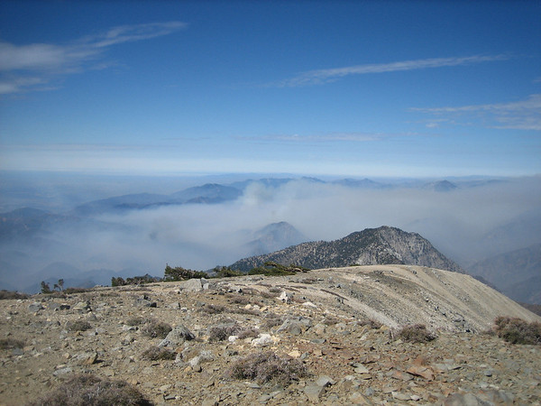
I went up Baldy today and added West Baldy in order to have a look at the fire. For a 4000 acre fire, it looked pretty quiet (it was 10:30 in the morning). There was no sign of aircraft. It was beautifully clear on Baldy and even Iron Mountain looked clear, as di deSan Antonio Ridge.

I was at the Burro Canyon Shooting Park with my crew on Saturday.
On Sunday I was backpacking in the San Gorgonio Wilderness with Ingrid and dog, and at about 3:00, when we got into our campsite at Limber Pine Bench (9,360 feet), I looked over towards the San Gabriels and saw a huge plume of smoke rising at least 5,000 feet into the sky. I could see it was beyond Mt Baldy and Ontario Peak and said, "Holy cow, that looks like it's burning right where we were yesterday."
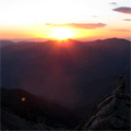
Eventually the smoke cloud rose to at least 20,000 feet. We could see how they seemed to get the fire under control near dusk, but then suddenly there was another big plume of smoke just before sundown. The sun set through the brown pall of smoke, it was gorgeous.
In the morning when we woke up there was no more smoke, but as we were making breakfast we looked back and there was a new cloud. This was a stubborn fire. Then within an hour the smoke was gone, and the entire hike back to the car we kept looking over and could see no more smoke.
When we first saw that huge cloud on Sunday afternoon all I could think of was another Station Fire. Glad it didn't come to that.
Pix: At 4:18pm:

At 5:06pm:

At 7:49pm:

Monday morning at 7:05am (with the shadow of San Bernardino peak at left):

We had a nice weekend. Shooting on Saturday and backpacking on Sunday and Monday. We sure enjoyed our Labor Day weekend more than the firefighters of the San Gabriels.
On Sunday I was backpacking in the San Gorgonio Wilderness with Ingrid and dog, and at about 3:00, when we got into our campsite at Limber Pine Bench (9,360 feet), I looked over towards the San Gabriels and saw a huge plume of smoke rising at least 5,000 feet into the sky. I could see it was beyond Mt Baldy and Ontario Peak and said, "Holy cow, that looks like it's burning right where we were yesterday."
Eventually the smoke cloud rose to at least 20,000 feet. We could see how they seemed to get the fire under control near dusk, but then suddenly there was another big plume of smoke just before sundown. The sun set through the brown pall of smoke, it was gorgeous.
In the morning when we woke up there was no more smoke, but as we were making breakfast we looked back and there was a new cloud. This was a stubborn fire. Then within an hour the smoke was gone, and the entire hike back to the car we kept looking over and could see no more smoke.
When we first saw that huge cloud on Sunday afternoon all I could think of was another Station Fire. Glad it didn't come to that.
Pix: At 4:18pm:
At 5:06pm:
At 7:49pm:
Monday morning at 7:05am (with the shadow of San Bernardino peak at left):
We had a nice weekend. Shooting on Saturday and backpacking on Sunday and Monday. We sure enjoyed our Labor Day weekend more than the firefighters of the San Gabriels.
Nunc est bibendum
Oh man, from our vantage high on the side of San Bernardino Peak, we could see that plume stretched out across the desert, at a right angle to us.
Nunc est bibendum

Here are some pictures of the Williams Fire from Copter Ridge. The plume of smoke was rising south of Rattlesnake Peak.
Approaching Copter Ridge point 7499'

Looking south from 7499'

Smoke plume over Rattlesnake Peak

Approaching Copter Ridge point 7499'
Looking south from 7499'
Smoke plume over Rattlesnake Peak


-
davantalus
- Posts: 203
- Joined: Mon Jun 08, 2009 9:09 am
I made some sortee's into Graveyard and Williams canyons a few years back. Got turned back by ticks and Poison Oak... May be time to return. 

Fire snuck into Devils Gulch and more of Shoemaker canyon. This appears to be the only front of the fire at this point. Total acres burnt went from 3800 to 4200.

Heres the modis map from photographyontherun.com showing the fire size in relation to previous fires.

Heres the modis map from photographyontherun.com showing the fire size in relation to previous fires.
I dont blame them one bit for letting that bushwack hell part of the ridgeline burn instead of digging linesHikeUp wrote: Wow. Now that it has passed that Rattlesnake-S. Hawkins ridgeline, they may not be able to stop it for a while.
AW - I'm looking forward to your Devils Gulch TR.
Zach stepped up to the plate and did the Devils Gulch route
Speaking of gold, I wonder what the situation with gold is in the burned areas. If my memory serves me correct, that was a gold mining area at one point. That plus landslides should bring in some prospectors. GOLD! hahaha....you mention that and some eyes light up.
Well then I will just have to beat the TR out of him the next time I see him.AW wrote: Zach stepped up to the plate and did the Devils Gulch route. I dont see any reason to repeat the route, unless Zach was actually covering up a paradise or gold location 8)
Its on this forum...
Anyways at 100% containment, $8.8 million
http://latimesblogs.latimes.com/lanow/2 ... -fire.html
"Forest Service spokesman Nathan Judy said agency investigators had determined that the blaze started Sept. 2 when the hot undercarriage of a car parked on an East Fork Road turnout ignited brush. He added that the investigation has been referred to federal prosecutors, who will determine what, if any, action will be taken against the driver of the car, who was not identified. "
Also, http://glendoramtnroad.blogspot.com/ and the Angeles website noted that Highway 39 was opened this morning. Although likely that could be not a guaranteed thing...GMR & GRR remained closed. Calfire notes "Planned Actions: Patrol and mop-up in all Divisions"
http://calfire.blogspot.com/
"ARCADIA, Calif.--Angeles National Forest has reopened the San Gabriel Canyon for recreational use. The Williams Fire has been declared 100% contained and the canyon is once again open to the public effective immediately. The canyon offers our visitors a variety of recreational opportunities including, fishing, picnicking and hiking.
Glendora Mountain Road and Glendora Ridge Road will remain closed awhile longer so that debris can be removed from the roads before reopening to the public. If you have questions regarding either of the Los Angeles County Roads please contact at (626) 458-5100 (M-Th)"