http://www.everytrail.com/view_trip.php?trip_id=1596250
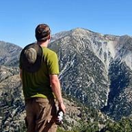
Near record pace for me to Mt Lukens via Stone Cyn Trail. Lost the data for my 1hr42min trip some years ago. If I hadn't stopped at all I'd have shaved 7min30sec off todays 1hr56min35sec. But I wasn't trying very hard either. As I recall I was splitting my sides when I did it in 1hr42min
Oh well Stone Cyn Trail has had some work done on it but it need lots more.
Looks like a combination of fire crews and single volunteers
I saw a bear about 1 year old or so.... very cool. It was about 50ft away
My heartfelt thanks to you all!
Mt Lukens via Stone Cyn Trail
Mt Lukens via Stone Cyn Trail -summit 1038-
-
mcphersonm80

- Posts: 243
- Joined: Mon Aug 23, 2010 11:46 am
Cool, thanks for the report. Encouraging to hear about the bear up there, good sign of recovery.
Any further details on the condition of the trail? I'd assume, like most other trails in the burn area, that poodle dog is everywhere and poor, sandy tread?
Looking forward to getting back up there, as this was the last hike I did before the fire broke out. If only I had known, I would have done Strawberry instead.
-
mattmaxon

- Posts: 1137
- Joined: Mon Mar 24, 2008 12:48 pm
Not lots of Poodle Dog. Seems you gotta get above 4500ft to see it in full force. It is spotty above 4500ft on Mt Lukens I think I saw the 1st poodle dog about 4120ft elevation about 2¾ milesmcphersonm80 wrote: Cool, thanks for the report. Encouraging to hear about the bear up there, good sign of recovery.
Any further details on the condition of the trail? I'd assume, like most other trails in the burn area, that poodle dog is everywhere and poor, sandy tread?
Looking forward to getting back up there, as this was the last hike I did before the fire broke out. If only I had known, I would have done Strawberry instead.
The tread is mostly in good shape but brush is coming back, right now it is mostly "Deer Weed" & "Chaparral Snap Dragon" Get out there and trample it!
There are 2 new slide areas, 1 is minor and the precise location escapes me right now ( above 1mile and below 1½ miles?). The Second isn't really a slide but a washout from the 1st post fire debris flow.
It is a spot about 2.1 miles up I called "Shady Rest". The trail is totally gone. The draw is scowered down about 6 ft from where it was. Doing something with this will be a chore. Will have to clear away the surrounding brush to formulate a restoration plan. But it will have to be some sort of stone retaining wall(s) / steps.
Don't see how else to fix it without extensive grading. This would be a Herculean task and environmentally damaging (IMO)
The damage is a bit surprising given the small drainage for this draw but it is what it is.
I'd like to see strawberry from the west side, without the trees and brush , there is likely more exposure
-
HikeUp

- Posts: 4042
- Joined: Thu Sep 27, 2007 9:21 pm
Nice TR and dang that's pretty fast! How's parking and crossing the river? Same as before?
-
mattmaxon

- Posts: 1137
- Joined: Mon Mar 24, 2008 12:48 pm
Parking is the same but the gate wasn't opened until 7 or so... I parked at MM 3.52 and hiked downHikeUp wrote: Nice TR and dang that's pretty fast! How's parking and crossing the river? Same as before?
The crossing is different just stay on the north side of the river until you see a dam about where stone cyn wash joins the river. crossing here seems the best for now.
Yeah I was a bit surprised to see my time... Like I said wasn't really trying to make any time.
