
Saw the news about the fire broke out this morning above Baldy Village. Man oh man! Temperature is rising this weekend. Hope the fire is contained by then.
http://cbs2.com/local/Mount.Baldy.Fire.2.722643.html
Fire above Baldy Village
-
Cy Kaicener
- Posts: 163
- Joined: Fri Sep 28, 2007 5:19 am
-
AlanK

- Posts: 1069
- Joined: Thu Sep 27, 2007 9:28 pm
The Bear Flat trail will look a lot different next time you're up there. 

-
FIGHT ON
Wow. I just found out. What a bummer. But after listening to that dude he said it has not burned since like 1975. Makes me wonder how often these mountains naturally burned before man started to put them out. But on the other hand how did this fire start? Man? Don't think it was lightning. 
-
Terry Morse
- Posts: 126
- Joined: Mon Mar 03, 2008 8:55 pm
There was no lightening last night, especially when it supposedly started at 4:30 AM. I guess we'll find out when they do an investigation.FIGHT ON wrote: But on the other hand how did this fire start? Man? Don't think it was lightning.
Do people camp up there overnight? Any homeless people living in that area? Could have been a campfire or a fire to keep someone warm during the cold nights. Just strange that it started at the time it did.
-
Rick M
- Posts: 61
- Joined: Mon Mar 17, 2008 4:11 pm
Terry wondered
Smoldering campfires (made perhaps last weekend) have been known to rekindle days later especially if you throw wind into the mix. Causes of fires in the wilderness are many...maybe even sparks from the hard high carbon steel tips of trekking poles against rocks?
Just strange that it started at the time it did.
Smoldering campfires (made perhaps last weekend) have been known to rekindle days later especially if you throw wind into the mix. Causes of fires in the wilderness are many...maybe even sparks from the hard high carbon steel tips of trekking poles against rocks?
-
Dudley Heinsbergen
- Posts: 109
- Joined: Tue Jan 22, 2008 9:02 pm
i guess on monday afternoon it sprinkled in Placentia, and i heard it rained a little in Palm Springs.
hard to believe it could have started from smoldering coals with so much moisture in the air.
hard to believe it could have started from smoldering coals with so much moisture in the air.
-
calicokid
- Posts: 90
- Joined: Wed Feb 27, 2008 1:07 pm
I hiked that Bear Flat trail last Friday and saw a few burned trees and I was wonder if it was the area got burned during the big fire of 2002-2003.
Felt sad a little this morning to see the same place was burning. Drove home from work and still see smoke in that area at 6:30pm.
I thought the bear canyon trail would become my favorite hike especially the view is grandeur in 360 degree on the trail. Now it becomes barren. another 4 years for rehab.
-
glamisking
- Posts: 89
- Joined: Sat Sep 29, 2007 4:04 pm
No. In less than a year it will covered in new beautiful growth like no one has ever seen in years. Sad now. But the Santiago fire burned up to my back fence this past Nov. and the wildflowers this spring were out of control.
The real bummer is the 12 or so months that the forest service will keep hikers out to allow for re-growth. But it is necessary to prevent erosion.
The real bummer is the 12 or so months that the forest service will keep hikers out to allow for re-growth. But it is necessary to prevent erosion.
-
Taco

- Snownado survivor
- Posts: 6133
- Joined: Thu Sep 27, 2007 4:35 pm
I saw the flames from dinner tonight in Diamond Bar.
Not a good thing to see a fire in our mountains. I just hope we don't get many this coming fire season.
On a humorous note, I was planning on going up Bear Flat Trail this weeked... guess those plans have changed.
Not a good thing to see a fire in our mountains. I just hope we don't get many this coming fire season.
On a humorous note, I was planning on going up Bear Flat Trail this weeked... guess those plans have changed.
-
Funyan005
- Posts: 203
- Joined: Tue Apr 01, 2008 11:17 pm
Can see the flames during the night, its pretty cool. Smoke during the day though isn't so neat looking
-
FIGHT ON
I bet all the areas were burned down a bunch of times over the past million years. Anybody know how often this used to happen? (like anyone here was around thenglamisking wrote:No. In less than a year it will covered in new beautiful growth like no one has ever seen in years. Sad now. But the Santiago fire burned up to my back fence this past Nov. and the wildflowers this spring were out of control.
The real bummer is the 12 or so months that the forest service will keep hikers out to allow for re-growth. But it is necessary to prevent erosion.
Why do they have to close down the area? Erosion on the trails? Just stay on the trails.
-
Hikin_Jim

- Posts: 4688
- Joined: Thu Sep 27, 2007 9:04 pm
It's a bummer is when nice trees get burned. Those don't come back quickly -- if they do come back. There are hikes in the Angeles where there are old, bleached stumps and stuff but not one single living tree.
There will be more erosion due to bare slopes but not due to hikers. The FS is paternalistically protecting us from ourselves. Hikers pose no threat of increased erosion. The FS closes things down "because someone might get hurt." Yeah, I guess, but it still feels overly paternalistic.
Of course we need to allow for re-growth, but I kind of don't get it. If people are hiking the Mt Baldy (aka Bear Flats) Trail, how does that contribute to erosion. The trail is bare now; the trail will be bare if people continue to hike. What's the difference? Am I missing something?glamisking wrote:The real bummer is the 12 or so months that the forest service will keep hikers out to allow for re-growth. But it is necessary to prevent erosion.
There will be more erosion due to bare slopes but not due to hikers. The FS is paternalistically protecting us from ourselves. Hikers pose no threat of increased erosion. The FS closes things down "because someone might get hurt." Yeah, I guess, but it still feels overly paternalistic.
-
JMunaretto
- Posts: 370
- Joined: Thu Feb 07, 2008 11:03 am
damnit! I've haven't done this trail and was planning on doing it soon, I guess I'll have to wait a year
-
HikeUp

- Posts: 4036
- Joined: Thu Sep 27, 2007 9:21 pm
In an ideal world I'd agree. But the truth is hikers cut switchbacks and the less brush there is the more likely they'll do so. They'll go straight up the hill and come straight down the hill making 2 new use trails that criss cross with the real trail. It can't be stopped.Hikin_Jim wrote:There will be more erosion due to bare slopes but not due to hikers.
Switchbacks are on the steepest slopes which are the most susceptible to erosion and cutting the switchbacks will exacerbate the problem. Blah blah blah.
The FS has to base their decisions on the lowest common denominator.
-
AlanK
- Posts: 1069
- Joined: Thu Sep 27, 2007 9:28 pm
From InciWeb.org this morning.

The Bighorn Fire began at approximately 4:30 a.m. on Tuesday, May 13, 2008. As of Wednesday, May 14, 2008 at 5:00 a.m. PST, the Bighorn Fire has burned approximately 310 acres north of the Mt. Baldy Village area within the Angeles National Forest. (See attached map.)
The fire is currently 10% contained. 396 multi-agency personnel are currently assigned to the fire. The cause is under investigation. The Angeles National Forest Fire Information Center will be open from 8:00 a.m. until 8:00 p.m. Phone: 626-821-6700.
Terrain - Steep - Medium Brush
Evacuations (5:00 a.m. May 14, 2008): Approximately 6 recreation residences in the vicinity of Bear Canyon continue to be evacuated.
Closure Update (5:00 a.m. May 14, 2008):Mt. Baldy Road at Shinn is closed to the public and open to residents only. Glendora Ridge Road is closed at Mt. Baldy Road and is closed at the East Fork.
-
glamisking
- Posts: 89
- Joined: Sat Sep 29, 2007 4:04 pm
Hikin_Jim wrote:It's a bummer is when nice trees get burned. Those don't come back quickly -- if they do come back.
After the Santiago fire I was surprised to see that over half of the 100+ year old oaks survived the fire. And if you think about it all the big pines and such have survived a numerous fires in their life time. Regardless it is disheartening to see the forest we love exploring burn.
Hike Up is exactly right about the potential for new trails to start up increasing the effect of hikers on the landscape. The wilderness around my house has been closed since Nov. for this reason. They hope to reopen it by August.
-
AlanK
- Posts: 1069
- Joined: Thu Sep 27, 2007 9:28 pm
Sadly, I have to agree. You and I would stick to the trail, but anyone actually responsible for the trail has to deal with the badly-behaved hikers as well as the cooperative ones.HikeUp wrote:But the truth is hikers cut switchbacks and the less brush there is the more likely they'll do so. They'll go straight up the hill and come straight down the hill making 2 new use trails that criss cross with the real trail. It can't be stopped.
Switchbacks are on the steepest slopes which are the most susceptible to erosion and cutting the switchbacks will exacerbate the problem. Blah blah blah.
The FS has to base their decisions on the lowest common denominator.
-
AW~

- Posts: 2092
- Joined: Mon Oct 01, 2007 12:00 pm
I suspect a lot of these shortcuts are done on the way down. Then again, sometimes the trails are built for a low grade as compared to built for erosion, and then contribute to erosion via landslides, etc. I take the trail but there are times of swtichbacks from hell that I am looking for an escape. For example, the Redbox-Rincon trail from Rincon...with its switchback from one side of Rincon canyon to the other and back...and then back again...oh man..if I were designing the hardest hike I would definitely start with some of those to get the hiker warmed up.
As for effects, read about Griffith Park. Article says Sierra Club as the impact culprit.
As for effects, read about Griffith Park. Article says Sierra Club as the impact culprit.
-
AlanK
- Posts: 1069
- Joined: Thu Sep 27, 2007 9:28 pm
I have not hiked in Griffith Park for a while, but I think the problem there may be that many of the hikes are on fire roads. There are use trails, some quite direct, that cut the fire road switchbacks. I can easily imagine hikers (from the Sierra Club or anyone else) doing that because they have been doing that for years. Of course, this could be having a negative impact -- I have not been to the Park since the fires and won't try to comment on that.AW wrote:As for effects, read about Griffith Park. Article says Sierra Club as the impact culprit.
-
Hikin_Jim
- Posts: 4688
- Joined: Thu Sep 27, 2007 9:04 pm
Oh. Yeah, good point. LOL I didn't even think of that. You mean everyone isn't just like me, zealously not cutting switchbacks?HikeUp wrote:In an ideal world I'd agree. But the truth is hikers cut switchbacks and the less brush there is the more likely they'll do so. They'll go straight up the hill and come straight down the hill making 2 new use trails that criss cross with the real trail. It can't be stopped.Hikin_Jim wrote:There will be more erosion due to bare slopes but not due to hikers.
Switchbacks are on the steepest slopes which are the most susceptible to erosion and cutting the switchbacks will exacerbate the problem. Blah blah blah.
The FS has to base their decisions on the lowest common denominator.
-
Hikin_Jim
- Posts: 4688
- Joined: Thu Sep 27, 2007 9:04 pm
Or the "Switchback of Despair" when the Forsee Cr Trail inexplicably takes a jog to the west, adding many unnecessary miles. The worst of it is that the Switchback of Despair doesn't really gain much in elevation. I just goes way out west and then climbs. Argh.AW wrote:I suspect a lot of these shortcuts are done on the way down. Then again, sometimes the trails are built for a low grade as compared to built for erosion, and then contribute to erosion via landslides, etc. I take the trail but there are times of swtichbacks from hell that I am looking for an escape. For example, the Redbox-Rincon trail from Rincon...with its switchback from one side of Rincon canyon to the other and back...and then back again...oh man..if I were designing the hardest hike I would definitely start with some of those to get the hiker warmed up.
Or the section of the Forsee Basin Trail that goes between Johns Meadow and the SB Pk Trl just past the meadow. It loses altitude just past the meadow before climbing up to the divide. What is up with that?
I too am a little more forgiving when a trail is horribly designed. In the case of the Forsee Basin Trail, there is a use trail that cuts out the downhill section. It really is more of a use trail rather than a shortcut that cuts right between switchbacks just to shave off a few extra feet. I don't have a problem with that use trail.
Do you have a link for that article on Griffith Park?AW wrote:As for effects, read about Griffith Park. Article says Sierra Club as the impact culprit.
HJ
-
simonov

- Posts: 1102
- Joined: Tue Nov 27, 2007 5:44 pm
- Location: Reno, NV
I like switchbacks.
If I didn't enjoy walking, I wouldn't be up there.
If I didn't enjoy walking, I wouldn't be up there.
Nunc est bibendum
-
AW~
- Posts: 2092
- Joined: Mon Oct 01, 2007 12:00 pm
Griffith Park link...reprint of Daily News article..w/that community's comments....
http://otbmbc.com/forum/YaBB.pl?num=1207886630/9
Heres a LA times article from 2006...I never knew up to 500 hikers were showing up at hikes.....talk about heavy demand.
http://www.latimes.com/news/local/valle ... 9106.story
http://otbmbc.com/forum/YaBB.pl?num=1207886630/9
Heres a LA times article from 2006...I never knew up to 500 hikers were showing up at hikes.....talk about heavy demand.
http://www.latimes.com/news/local/valle ... 9106.story
-
Mike P

- Posts: 1005
- Joined: Tue Oct 02, 2007 10:48 pm
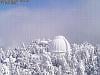
Here is a picture from the Mt Wilson cam from last night:


-
Mike P
- Posts: 1005
- Joined: Tue Oct 02, 2007 10:48 pm
Since we are on the subject of Griffith Park. Here is a picture from last year's fire:

Before y'all think I am a firebug... the Mt Wilson cam is generally turned to where the action is. I have saved all sorts of cool pictures over the last few years.
Mt Wilson cam: http://www.astro.ucla.edu/~obs/towercam.htm
Before y'all think I am a firebug... the Mt Wilson cam is generally turned to where the action is. I have saved all sorts of cool pictures over the last few years.
Mt Wilson cam: http://www.astro.ucla.edu/~obs/towercam.htm
-
Funyan005
- Posts: 203
- Joined: Tue Apr 01, 2008 11:17 pm
So you're the one setting these fires!I am a firebug
Thanks for the link of the wilson cam.
Anyone have any updates on the fire? I didnt see much smoke today from it.
-
HikeUp
- Posts: 4036
- Joined: Thu Sep 27, 2007 9:21 pm
I use the www.inciweb.org site for most info on road closures and fire info.Funyan005 wrote:Anyone have any updates on the fire? I didnt see much smoke today from it.
With the Mt. Baldy Road closed at Shinn, there is no access to any of the trail heads including Icehouse and Manker.