Clamshell, Rankin, Monrovia, Pine (NHPS)

TRs for the San Gabriel Mountains.
User avatar
turtle
Posts: 152
Joined: Wed Jan 27, 2010 11:35 am

Post by turtle »

Dreadful.

To quote canyoneer Tom Jones: "I did it so that you don't have to...".


Image
User avatar
HikeUp
Posts: 3861
Joined: Thu Sep 27, 2007 9:21 pm

Post by HikeUp »

You need your head examined. :|

That's a lot miles dude. Nice touch on almost making it to Pine and the saddle before Pine :lol:

Oh, and you were reasonably close to Mt. Bliss!
User avatar
Taco
Snownado survivor
Posts: 6010
Joined: Thu Sep 27, 2007 4:35 pm

Post by Taco »

Oh man, that looks like fun!!! 8)
User avatar
hvydrt
Posts: 494
Joined: Thu Sep 27, 2007 8:18 pm

Post by hvydrt »

Dang! What were the stats on that???
User avatar
turtle
Posts: 152
Joined: Wed Jan 27, 2010 11:35 am

Post by turtle »

HikeUp wrote: Oh, and you were reasonably close to Mt. Bliss!
You're right... didn't notice that when I was planning the route. Would have much rather tagged Bliss than done the rather pointless out and back towards Pine. :(
User avatar
turtle
Posts: 152
Joined: Wed Jan 27, 2010 11:35 am

Post by turtle »

Taco wrote: Oh man, that looks like fun!!! 8)
The Ruby Canyon -> Clamshell Peak segment and Rankin Peak -> Monrovia Peak segment will most surely disabuse you of that notion. :lol:
User avatar
turtle
Posts: 152
Joined: Wed Jan 27, 2010 11:35 am

Post by turtle »

hvydrt wrote: Dang! What were the stats on that???
Stout, but not all that bad -- something like 20M, +/-7K.

But the off (overgrown?) trail stretches were quite painful, especially in shorts. :oops:

The initial climb to Clamshell peak reminded me of our good friend Iron -- very steep and loose in places -- but with dense (though thankfully low) brush and a bit of poodle dog bush mixed in. Throw in a hot sun and you get the idea...
User avatar
lilbitmo
Posts: 1092
Joined: Tue Mar 04, 2008 9:44 pm

Post by lilbitmo »

Turtle, way to bank out the distance in crazy terrian - we are considering going back to tag our friend that we missed three weeks ago, next weekend, let me know if you can join us. :D
User avatar
cougarmagic
Posts: 1409
Joined: Wed May 07, 2008 5:21 pm

Post by cougarmagic »

That looks delightful. I think I'll wait until winter to hike this though, so I can become covered in ticks.
User avatar
Taco
Snownado survivor
Posts: 6010
Joined: Thu Sep 27, 2007 4:35 pm

Post by Taco »

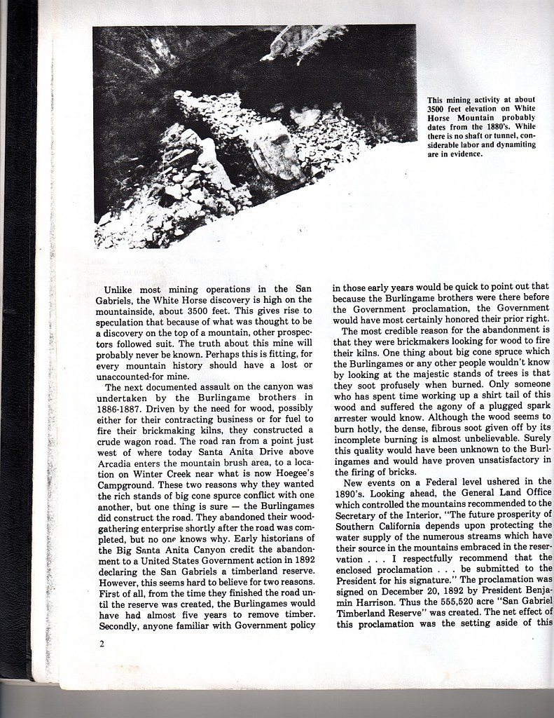
cougarmagic wrote: That looks delightful. I think I'll wait until winter to hike this though, so I can become covered in ticks.
:lol: :lol: :lol: :lol: :lol: :lol: :lol:

Turtle, is there something cool over there? Some cool... canyon... stuff? Or are you kidding and it just sucks everywhere forever?
User avatar
PackerGreg
Posts: 623
Joined: Sat Sep 12, 2009 9:31 pm

Post by PackerGreg »

Did you find any WWII-era Japanese spy equipment?
User avatar
AW~
Posts: 2043
Joined: Mon Oct 01, 2007 12:00 pm

Post by AW~ »

For the life of me, I dont understand why you wouldnt go all the way to Pine :wink: oh..and beyond that the switchback down to Hwy39 in the summer time.
User avatar
turtle
Posts: 152
Joined: Wed Jan 27, 2010 11:35 am

Post by turtle »

Taco wrote: Turtle, is there something cool over there? Some cool... canyon... stuff? Or are you kidding and it just sucks everywhere forever?
I didn't notice anything particularly enticing, though I can't say I was in the happy and exploratory frame of mind.

From the onset, this was about getting the miles done...
User avatar
turtle
Posts: 152
Joined: Wed Jan 27, 2010 11:35 am

Post by turtle »

PackerGreg wrote: Did you find any WWII-era Japanese spy equipment?
Sounds like there's an interesting story here... what did I miss?

I did collect a few of what looked like multi-layer insulation blankets from some form of reconnaissance craft. But why the Japanese would mark them "You're My Sweetie!" and "Congratulations Old Fart!" is beyond me. :wink:
User avatar
Dave G
Posts: 321
Joined: Sun Jun 22, 2008 9:51 am

Post by Dave G »

turtle wrote:
PackerGreg wrote: Did you find any WWII-era Japanese spy equipment?
Sounds like there's an interesting story here... what did I miss?

I did collect a few of what looked like multi-layer insulation blankets from some form of reconnaissance craft. But why the Japanese would mark them "You're My Sweetie!" and "Congratulations Old Fart!" is beyond me. :wink:
:lol: :lol: :lol:
Yeah, they got a strange sense of humor. We should start moving all those mylars to designated cache points. In an emergency, somebody could splice 'em together with tree sap and create a "sustainable" space blanket of sorts. :wink:

Nice endurance run, Mark!
User avatar
PackerGreg
Posts: 623
Joined: Sat Sep 12, 2009 9:31 pm

Post by PackerGreg »

Some folks I know found an old mine on White Horse Mountain back in the 1970's. It has since been presumed to be left over from the Mt Wilson gold rush. But when the guys I know discovered it, there was camping gear, radios, telescopes etc labeled in Japanese. From White Horse there is a clear view down Big Santa Anita Canyon to the LA Harbor.
User avatar
Taco
Snownado survivor
Posts: 6010
Joined: Thu Sep 27, 2007 4:35 pm

Post by Taco »

LOL

Greg, that's an awesome story. Very interesting. You're not pulling our chains are ya?
User avatar
PackerGreg
Posts: 623
Joined: Sat Sep 12, 2009 9:31 pm

Post by PackerGreg »

No, that mine is there, and documented in Glen Owens' Heritage of the Big Santa Anita. The man that told me about it and the gear found outside the entrance still has a cabin in Big SAC. He said he has been inside the mine with the nephew of a former pack station owner. It was a tight squeeze and not much in the way of a shaft, but it would have made suitable shelter from the elements.
User avatar
PackerGreg
Posts: 623
Joined: Sat Sep 12, 2009 9:31 pm

Post by PackerGreg »

Regarding White Horse Mine: first image, last paragraph; second image, first paragraph plus photo & caption...

Image

Image
User avatar
Taco
Snownado survivor
Posts: 6010
Joined: Thu Sep 27, 2007 4:35 pm

Post by Taco »

Thanks Greg! 8)
User avatar
everyday
Posts: 455
Joined: Tue Mar 15, 2011 12:36 pm

Post by everyday »

ok, thisll make me look stupid...but so how far and in what time did you do this? All i see is a picture of a topo map i dont know how to read.--its just a buncha squigly lines ...no readable milage to me ...so what was yer distance, time, elevation, terrain please for trailrunning stuffs? :D

Also!! how come i always do 15-20 miles in desert n canyon/mtns in 4hrs or less w/5000ft or more of elevation change, and can run to bottom of GC n up in under 4 hrs....but when i post this NO one says ANything..except Taco, why does his run get tons of congrats n I hear nothing?? cause ima girl? or cause i dont know how to make a pretty map of it??? :shock:
Im being serious..Woulda map help? if so, how do i find coordinates or whatever, to map stuff? like how would i find lat/lon. for kaibab trailhead, phantom ranch and BA trails here at the GC? so i can add em to my TR?Ide totally make cool maps if i knew how! :) if you know how, PM me instructions or something, thanx
User avatar
Dave G
Posts: 321
Joined: Sun Jun 22, 2008 9:51 am

Post by Dave G »

everyday wrote: ok, thisll make me look stupid...but so how far and in what time did you do this? All i see is a picture of a topo map i dont know how to read.--its just a buncha squigly lines ...no readable milage to me ...so what was yer distance, time, elevation, terrain please for trailrunning stuffs? :D

Also!! how come i always do 15-20 miles in desert n canyon/mtns in 4hrs or less w/5000ft or more of elevation change, and can run to bottom of GC n up in under 4 hrs....but when i post this NO one says ANything..except Taco, why does his run get tons of congrats n I hear nothing?? cause ima girl? or cause i dont know how to make a pretty map of it??? :shock:
Im being serious..Woulda map help? if so, how do i find coordinates or whatever, to map stuff? like how would i find lat/lon. for kaibab trailhead, phantom ranch and BA trails here at the GC? so i can add em to my TR?Ide totally make cool maps if i knew how! :) if you know how, PM me instructions or something, thanx
That's really fast! I was born in Tempe, but I'm ashamed to say that I've never hiked the Grand Canyon. Gotta get to that one of these days.

When people post a map, it's usually just their GPS track. It sounds like you're into trail running, so maybe you don't carry a GPS cuz they're heavy? No big deal. Maps are cool, but sometimes a story with some photos can be just as informative and interesting.

If you're interested, REI has free introductory map reading and GPS classes, plus there are a bunch of web sites that have good info.
User avatar
HikeUp
Posts: 3861
Joined: Thu Sep 27, 2007 9:21 pm

Post by HikeUp »

I was impressed that a turtle could cover 20+ miles in that terrain.
User avatar
Hikin_Jim
Posts: 4686
Joined: Thu Sep 27, 2007 9:04 pm

Post by Hikin_Jim »

everyday wrote: Also!! how come i always do 15-20 miles in desert n canyon/mtns in 4hrs or less w/5000ft or more of elevation change, and can run to bottom of GC n up in under 4 hrs....but when i post this NO one says ANything..except Taco, why does his run get tons of congrats n I hear nothing?? cause ima girl? or cause i dont know how to make a pretty map of it??? :shock:
Im being serious..Woulda map help? if so, how do i find coordinates or whatever, to map stuff? like how would i find lat/lon. for kaibab trailhead, phantom ranch and BA trails here at the GC? so i can add em to my TR?Ide totally make cool maps if i knew how! :) if you know how, PM me instructions or something, thanx
Hey! I comment on some of your posts. What am I, chopped liver? :?

HJ
User avatar
lilbitmo
Posts: 1092
Joined: Tue Mar 04, 2008 9:44 pm

Post by lilbitmo »

everyday wrote: ok, thisll make me look stupid...but so how far and in what time did you do this? All i see is a picture of a topo map i dont know how to read.--its just a buncha squigly lines ...no readable milage to me ...so what was yer distance, time, elevation, terrain please for trailrunning stuffs? :D

Also!! how come i always do 15-20 miles in desert n canyon/mtns in 4hrs or less w/5000ft or more of elevation change, and can run to bottom of GC n up in under 4 hrs....but when i post this NO one says ANything..except Taco, why does his run get tons of congrats n I hear nothing?? cause ima girl? or cause i dont know how to make a pretty map of it??? :shock:
Im being serious..Woulda map help? if so, how do i find coordinates or whatever, to map stuff? like how would i find lat/lon. for kaibab trailhead, phantom ranch and BA trails here at the GC? so i can add em to my TR?Ide totally make cool maps if i knew how! :) if you know how, PM me instructions or something, thanx
We are impressed with what you post, just some of us don't run so it's hard to compare to what we do, Turtle's route was through some seriously thick "Shit" for lack of better term - some of these trails are beat up and need maintenance - Torry your canyoneer trips with Taco are assume - keep them coming and we will start giving you the more props as you deserve - The GC at this time of the year is hot, If I ran down there you'd be calling SAR to recover the body - me run + heat = trouble (go get the body) :D
User avatar
turtle
Posts: 152
Joined: Wed Jan 27, 2010 11:35 am

Post by turtle »

everyday wrote: All i see is a picture of a topo map i dont know how to read.--its just a buncha squigly lines ...no readable milage to me ...so what was yer distance, time, elevation, terrain please for trailrunning stuffs? :D

Hi Everyday. I was assuming that at least a few on the forum familiar with that area would have some idea of the terrain on the first half of the route. For me, that's more what made this trip unique -- and not in a good way. :)

I didn't post the distance and elevation because I didn't feel they were (in and of themselves) all that noteworthy. For the record, I estimate the distance at 20 miles, and the elevation gain and loss around 6500 feet. I started at 5:10am and finished at 1:00pm, so about 7:50 in total.

More than kudos on distance or pace, I was looking for commiseration in selecting what was clearly (at least in hindsight) an ill-advised route. HikeUp's initial comment really made me smile. I also hoped this thread would be a "cautionary tale" to others -- the route really has little to recommend it. :!:
everyday wrote: Also!! how come i always do 15-20 miles in desert n canyon/mtns in 4hrs or less w/5000ft or more of elevation change, and can run to bottom of GC n up in under 4 hrs....but when i post this NO one says ANything..

I'll say it... that's damn fast! :shock:
everyday wrote: Woulda map help? if so, how do i find coordinates or whatever, to map stuff? like how would i find lat/lon. for kaibab trailhead, phantom ranch and BA trails here at the GC? so i can add em to my TR?Ide totally make cool maps if i knew how! :) if you know how, PM me instructions or something, thanx
I think maps are always appreciated on the forum, as many of us are map junkies. And few would disagree that map reading is a skill well worth developing. It goes a long way towards keeping you safe in the wilds and can provide literally hours of enjoyment at home. At the risk of getting overly philosophical, I'd say maps can provide a sense of immediacy to the terrain that words (or even pictures) cannot, much as art can convey emotions or ideas that words cannot reach. For me, pouring over topographic maps is at once intriguing, soothing, and inspiring.

There are lots of good books and web pages on reading maps. Mountaineering: Freedom of the Hills has a nice section on navigation, though as a trail runner, you might want to check out those aimed at orienteers (who are also travelling fast and light).

Finally, if you look in the header of the map I posted, you'll see it was created using TOPO!. It does support the overlay of GPS tracks, but the trace shown in my map was created manually the day before my outing.
User avatar
HikeUp
Posts: 3861
Joined: Thu Sep 27, 2007 9:21 pm

Post by HikeUp »

Also note that this hike was in the San Gabriels and thus a bunch more people will be familiar with it and will be more likely to comment.

BTW, as a general rule I think most people need their heads examined, especially those that hang out here on this forum and specifically those that enjoy running :D

Full disclosure - I hate running.
User avatar
everyday
Posts: 455
Joined: Tue Mar 15, 2011 12:36 pm

Post by everyday »

@ turtle-thats really good time from what ive seen of some of the terrain up there! , unfornunatly Taco took me to a lovely overgrown place too, lol.

@Dave G--ya, eets HOT! thats why I start at 5am n get back to the top by 10am at the latest!

@ hikin-jim, i dont think youre liver :D

@ everyone else--thanx for the nice responses!!! I thought i had maybe come off sounding a bit bitchy, but did not intend it that way, so im glad u guys didnt take it that way...I can be really blunt sometimes and its often misunderstood.

I wish i could afford a map-making gps thingy...ill c if i can get one for Xmas from my Dad! ha! ill check out TOPO too
User avatar
Hikin_Jim
Posts: 4686
Joined: Thu Sep 27, 2007 9:04 pm

Post by Hikin_Jim »

everyday wrote: I wish i could afford a map-making gps thingy...ill c if i can get one for Xmas from my Dad! ha! ill check out TOPO too
There's always ACME mapper which is free on the web.

HJ
User avatar
Mike P
Posts: 1005
Joined: Tue Oct 02, 2007 10:48 pm

Post by Mike P »

everyday wrote: ok, thisll make me look stupid...but so how far and in what time did you do this? All i see is a picture of a topo map i dont know how to read.--its just a buncha squigly lines ...no readable milage to me ...so what was yer distance, time, elevation, terrain please for trailrunning stuffs? :D

Also!! how come i always do 15-20 miles in desert n canyon/mtns in 4hrs or less w/5000ft or more of elevation change, and can run to bottom of GC n up in under 4 hrs....but when i post this NO one says ANything..except Taco, why does his run get tons of congrats n I hear nothing?? cause ima girl? or cause i dont know how to make a pretty map of it??? :shock:
Im being serious..Woulda map help? if so, how do i find coordinates or whatever, to map stuff? like how would i find lat/lon. for kaibab trailhead, phantom ranch and BA trails here at the GC? so i can add em to my TR?Ide totally make cool maps if i knew how! :) if you know how, PM me instructions or something, thanx
Careful there, Everyday. We might have to call the "waaaahmbulance" for you. :)
Post Reply