
Baldy Register Ridge and Ski Hut 5-3-08

I went up Register Ridge and came down the Ski Hut Trail today. The entire loop was almost entirely clear of snow. There were a few sections where I walked across a few dozen feet of snow and it was soft, and avoidable if one prefers that approach. There was virtually no snow between the summit and the top of the bowl and only patchy snow in the woods. So, you can do the Ski Hut Trail without ice axe, crampons, etc. I forgot my camera, so no pictures. 
-
FIGHT ON
No camera??????????????????? what is that? you need to go back there right now and take those PICTURES! now get. 
-
FIGHT ON
So right after you leave that dirt road there is a trail on the right? Pretty cool. and STEEP!  looks like it's really steep. Is it a trail or just like a ridge thing that you just stay on? And you forgot your camera.

-
FIGHT ON
Looks like a great hike. It's legal to go anywhere you want? I know that sounds stupid but I thought people were supposed to stay on trails cuz they mess up little plants and cause erosion. Don't blame me for going on that trail now. I doubt I would have learned of it for years.
-
JMunaretto
- Posts: 370
- Joined: Thu Feb 07, 2008 11:03 am
great! can't wait to be up there tomorrow
Today (Saturday, 5/3/2008) I hiked Baldy Loop (up Ski Hut Trail, down DBB). Observations:
-- Crowded! At least 3 dozen hikers at Baldy Summit when I was there ~11:30 a.m. No privacy for normal bodily functions for most of the loop. After port-a-potties at Manker Flat, I had to "hold it" all the way up SHT, past the summit, and down DBB until I found a quiet place in the ski area. For me, that's a long time!
-- First snow on the trail was on the switchbacks after Ski Hut; snow covered about 50% of ground in this area; regular hiking shoes were fine, following well-stomped footprints in hard-packed snow; my boots did not slip on snow, not once.
-- Although most hikers traversed these slightly-snowy switchbacks without concern, I met a half a dozen hikers descending Ski Hut Trail who told me that they turned around when they saw the snowy switchbacks. Said one, "I have to go to work on Monday."
-- Above the switchbacks, along the ridge leading to Baldy Summit, the trail was 99.9% clear of snow.
-- Most of summit was clear of snow. (Barely a breeze blowing when I happened to be at the summit.)
-- Trail leading off summit toward DBB, the slippery gravel, was clear of snow.
-- On DBB, there were a few spots next to trees, none hazardous, where I had to step over a small snowbank.
-- In the ski area, near the first ski lift machinery encountered, there was a field of snow to navigate through or around.
-- It looked like a good business day for the ski lift, and a glorious hiking day for all!

Snow is scary and dangerous, and reported to hold people up and steal their lunchmoney.
8)
Register ridge is easy to follow, trail or no trail, really. Just follow the ridge up. The only thing I had an issue with when doing it a year ago or whenever, was getting back onto it from DBB trail. YOu just hafta terrain associate your way onto it.
8)
Register ridge is easy to follow, trail or no trail, really. Just follow the ridge up. The only thing I had an issue with when doing it a year ago or whenever, was getting back onto it from DBB trail. YOu just hafta terrain associate your way onto it.
One can see from reading these pages that a lot of interesting trips are largely, or completely, off trail. In areas where there are trails, cutting switchbacks is not acceptable because it causes erosion. This is especially true in cases like the Ski Hut Trail, which gets huge volumes of traffic. But that does not mean that all hikes have to be confined to trails. In the case of Register Ridge, the use trail is getting to be pretty well-defined.FIGHT ON wrote:Looks like a great hike. It's legal to go anywhere you want? I know that sounds stupid but I thought people were supposed to stay on trails cuz they mess up little plants and cause erosion. Don't blame me for going on that trail now. I doubt I would have learned of it for years.
99% of the world is off-trail.
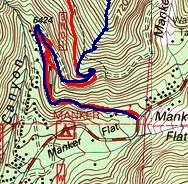
Here's a picture showing the trail start:
http://www.summitpost.org/image/290796/ ... ridge.html
Here's a picture showing the trail start:
http://www.summitpost.org/image/290796/ ... ridge.html

I was just up there today and made a mental note to look for the turn-off. It's not at the register. It's just a bit after you make the right turn once you pass the register. It's very obvious once you know that it exist, but easy to miss if you don't--kinda like the turn off to the Ski Hut trail from Falls Rd.

A lot of the routes to Baldy involve some XC. Naturally, FIGHT ON, we expect you to post a TR for each of these:FIGHT ON wrote:Looks like a great hike. It's legal to go anywhere you want? I know that sounds stupid but I thought people were supposed to stay on trails cuz they mess up little plants and cause erosion. Don't blame me for going on that trail now. I doubt I would have learned of it for years.
1. Baldy via Baldy Notch
2. Baldy via Ski Hut Trail
3. Baldy via Register Ridge (XC)
4. Baldy via Pine and Dawson (XC)
5. Baldy from the Village
6. Baldy via San Antonio Ridge (XC)
7. Baldy via Bighorn Ridge (XC)
If you're really good, then you do multiple ascents in a single day via different routes. We'll be looking for those TR's Don't let us down.
HJ
(OK, in all fairness, #7 is hardly a standard route anymore, but we know you can do it. Don't forget the way points.)
You laugh, but that's about what Rick K drinks. And he did Baldy via San Antonio Ridge, then went down Ski hut to Manker to the little snack bar, and then went back up Baldy via ski hut and descended to Heaton via San Antonio Ridge. I bet he "cheated" and drank something at the snack bar. 
No cheating for you, FIGHT ON. I will personally guard the snack bar to keep you honest.
No cheating for you, FIGHT ON. I will personally guard the snack bar to keep you honest.
Read 'em and weep: http://www.mt-whitney.info/viewtopic.php?t=1908Rob wrote:I wonder if Rick K holds the record for best time on "Heaton to Manker Flat Snack Bar" double traverse?
Actually, I was wrong. Rick took 3.5L of water. And he had a smoothie at the snack bar. Definitely cheating.
19 hours. Now that's a marathon. This ranks right up there on the "hardest hikes" in S Cal. list. Got to.
There are rumors to that effect. On the other hand, he is a programmer/analyst. Perhaps he's coded a replicant?
The start of the Ski Hut Trail is in red and the Register Ridge one is in blue.Tim wrote:I was just up there today and made a mental note to look for the turn-off. It's not at the register. It's just a bit after you make the right turn once you pass the register. It's very obvious once you know that it exist, but easy to miss if you don't--kinda like the turn off to the Ski Hut trail from Falls Rd.
-
FIGHT ON
Ok. The way I figure it, ya walk along the yellow the dirt road, do a u turn when you see a big waterfall, walk along some more and keep an eye out on the left. Right? Then when you see the unmarked trail on he left, go up it. Count 237 paces, stop, company right, look up and get to gettin. Zat it? 

I don't know if it's 237 paces, but it is a minute or so after you pass the register and the ridge is fairly obvious if you're looking for. It is a beautiful ridge and I've seen bighorn on it. Take it up to where you cross the backbone trail and go straight up to Harwood. Then hang a left down into the saddle and up to Old Baldy.FIGHT ON wrote:Ok. The way I figure it, ya walk along the yellow the dirt road, do a u turn when you see a big waterfall, walk along some more and keep an eye out on the left. Right? Then when you see the unmarked trail on he left, go up it. Count 237 paces, stop, company right, look up and get to gettin. Zat it?