Good time to hike 3 T's & Cucamonga & Camp @ Kelly's
-
tarol
- Posts: 126
- Joined: Tue Nov 06, 2007 12:28 pm
I want to camp at Kelly's Camp and hike the 3 T's and Cucamonga Peak. Probably start from Baldy Notch and do the 3 T's first, camp, then Cucamonga Peak, then down Icehouse. I'd like to have water at Kelly's, but no snow or ice on the trail. I'm thinking mid-May? What do y'all think?
-
Hikin_Jim

- Posts: 4688
- Joined: Thu Sep 27, 2007 9:04 pm
At last report, the spring at Kelly's was dead. Spring box probably collapsed or filled in. There may be water in the drainage below.
HJ
HJ
-
asbufra
- Posts: 135
- Joined: Sun Oct 26, 2008 10:27 pm
Of course this is just a guess, but I think there will still be snow in many places on those trails in mid May.
Jim is correct, the pipes at Kelly were dry last summer.
Jim is correct, the pipes at Kelly were dry last summer.
-
Illusive
- Posts: 115
- Joined: Fri Jan 28, 2011 2:19 pm
Your best reliable source of water would be from columbine spring south of icehouse saddle. It would add a bit of elevation gains but at least its a reliable water source.tarol wrote: I want to camp at Kelly's Camp and hike the 3 T's and Cucamonga Peak. Probably start from Baldy Notch and do the 3 T's first, camp, then Cucamonga Peak, then down Icehouse. I'd like to have water at Kelly's, but no snow or ice on the trail. I'm thinking mid-May? What do y'all think?
When ever I dry camp at Ontario or Cucamonga I fill up at Columbine and haul the rest up to the summit.
Last year Kelly's was dry as the others have said.
-
Hikin_Jim
- Posts: 4688
- Joined: Thu Sep 27, 2007 9:04 pm
Fixing the spring box at Kelly's would be a great Eagle Scout project for some kid... (hint, hint, Dave G)
HJ
HJ
-
Hikin_Jim
- Posts: 4688
- Joined: Thu Sep 27, 2007 9:04 pm
Yeah, one wonders although there wouldn't be any violation of the Wilderness Act per se since there would be no pumps or other mechanical apparatus.
HJ
HJ
-
simonov

- Posts: 1108
- Joined: Tue Nov 27, 2007 5:44 pm
- Location: Reno, NV
It would still be an "improvement." Unless the Forest Service considered the original spring box to be grandfathered.
The Forest Service dismantled all those makeshift ski huts above South Fork Meadows because they were unauthorized improvements (even though they were built before the Wilderness Act). For that matter, I wonder what justification they used for dismantling the buildings at Kelly's Camp itself? Attractive nuisance?
The Forest Service dismantled all those makeshift ski huts above South Fork Meadows because they were unauthorized improvements (even though they were built before the Wilderness Act). For that matter, I wonder what justification they used for dismantling the buildings at Kelly's Camp itself? Attractive nuisance?
Nunc est bibendum
-
Hikin_Jim
- Posts: 4688
- Joined: Thu Sep 27, 2007 9:04 pm
Good question.
I wonder if the idea could be "sold" on the premise that it would help Bighorn sheep?
HJ
I wonder if the idea could be "sold" on the premise that it would help Bighorn sheep?
HJ
-
tarol
- Posts: 126
- Joined: Tue Nov 06, 2007 12:28 pm
Thanks for the info on the spring. How much elevation gain between Columbine Spring and the saddle?

-
Illusive
- Posts: 115
- Joined: Fri Jan 28, 2011 2:19 pm
As previously stated it adds about 900' in decent / acent. The spring is at about 6600 feet. I also made an error on the direction of the spring. I tend to think of things behind me on a trail as south.tarol wrote: Thanks for the info on the spring. How much elevation gain between Columbine Spring and the saddle?
On the actual map, the spring is west/northwest of icehouse saddle. You can see its exact location here Labled point A:
http://mapper.acme.com/?ll=34.24257,-11 ... Baldy%20CA
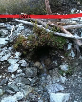
The trail actually crosses over the top of the spring and there is a small 10-15' use trail that decends the 6' or so down to it.
The distance from the spring to the saddle is 1.2 miles roughly.
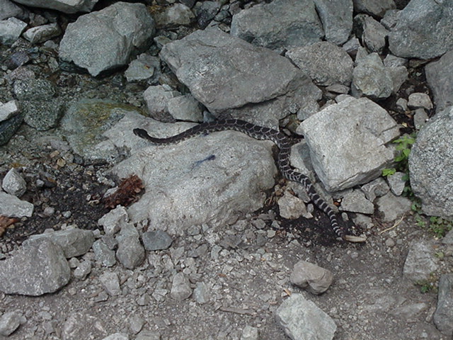
Here's a photo of the spring also:
-
RichardK

- Posts: 727
- Joined: Sun Sep 30, 2007 12:33 pm
The opening to the spring has been enlarged from when we first saw it 13 years ago. Someone took it upon themselves to "improve" the spring.
Here is a picture of a rattlesnake drinking from the spring. The picture was made on July 22, 2000, with an old 1.3 MP camera.