It was great being up there on that cloudy, and very humid morning. I setup my tarp using my trekking poles and a large rock and pulled out my stove. I could not find my lighter but I had matches, only problem is that I could not get them to light! After going through about 20 I discovered that there was a bit of sandpaper in a small Ziploc bag stuffed in the plastic survival match box! Using the sandpaper, the 1st match lit up and I was only a few minutes away from eating a hot breakfast.
I dug out a flat spot for my stove and uncovered a little Horny Toad Lizard, he did not look happy to be dug up from his lair so I put him on a rock next to my stove so he could warm up.
After breakfast I tore down camp but before leaving I made the lizard a new home by stacking up some nice rocks and covering it in dirt. It was the least I could do since I had destroyed his last home
*********
The next trip, I really wanted to do a longer trek and I had spotted a trail, on the previously mentioned hike, in the drainage of Snow Creek (can anyone verify that…?) coming off of Mt. Harvard. So on Saturday I did some snooping and discovered the Mt. Wilson trail (I was aided by a bit of Google Maps work the night before too). I had gotten a late start on Saturday so I did not get on the trail till after 1:00pm (good case of lazy Saturday).
It was humid down low but as the trail climbed, and boy is it steep, the temps cooled. The views of the creek crashing down the rocky canyon were stunning and the hillsides were covered in green grass and wildflowers of every color.
It was perfect day. There were quite a few people on the trail but once I passed the 1st water point (where the trail drops down into the creek) the crowds thinned out and I had long periods of solitude where I could hear the birds singing, the wind blowing in the trees and the water babbling in the creek below. As I continued up I was climbing into the cloud cover and right around the Orange Grove Campground (I have a bad memory so if I'm remembering wrong the name of that campground feel free to correct me) I came out into the sun.
There was a nice breeze and the trail was well covered with trees and brush so it stayed nice and cool. About 2 miles from where the Mt. Wilson trail reaches the Mt. Wilson Toll Road I crossed a creek and figured that I should refill my reservoir as I figured it would be the last water for the rest of the way up (I was right, no water till the summit & will get to that in a bit). I like to fill up my reservoir in my pack because it keeps it upright and I do not have to worry about the reservoir tipping over and spilling out all my freshly purified water.
Well I was so enthralled by the scenery that I did not realize I had filled up my reservoir and was pumping water straight into my pack!
When I finally snapped back to reality I had a good amount of water in the bottom of my pack. It was totally soaked but at least all my clothing items were in dry bags
I continued the hike up soaking in the scenery and before I knew it I was nearing the summit of Mt. Wilson.
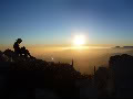
Now I knew that Mt. Wilson had radio towers on it and an observatory but I was not prepared for a humongous parking lot and a snack bar! (they were open and serving nachos and hot dogs!) or the bathroom on top complete with running water, soap and paper towels… Kind of a buzz kill not going to lie… After all that work to get there only to be met with pavement, electricity, fresh food and teenage girls texting and OMG'ing about the boys at school. Nevertheless the views were pretty amazing, the clouds looked like a fuzzy white carpet and watching the mist blow up the side of the mountain was impressive.
But I could not spend much time at the summit, I wanted to get down before dark so I beet feet back down the way I came.
It took 3 hours 15 minutes to go up and 2 hours and 10 minutes to come down. Overall it was 13.75 miles, according to my GPS, round trip and by the time I got back to the car my left knee and feet were killing me! Might be time for some new insoles...
Pheww what a hike!