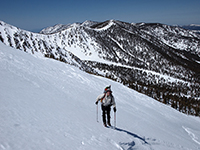
Whitewater to Dragonhead.
-
jjpicts

- Posts: 18
- Joined: Wed Feb 03, 2010 2:56 pm
Has anyone done a trip up Whitewater to Dragonhead. in winter conditions? Was looking over there coming down tram yesterday and it looked interesting.
-
Taco

- Snownado survivor
- Posts: 6136
- Joined: Thu Sep 27, 2007 4:35 pm
Got a picture of what you've envisioned?
-
jjpicts

- Posts: 18
- Joined: Wed Feb 03, 2010 2:56 pm
Don't know how to post them but here's a link to them.Taco wrote: Got a picture of what you've envisioned?
https://picasaweb.google.com/1170959980 ... 4627/Picts#
-
Taco

- Snownado survivor
- Posts: 6136
- Joined: Thu Sep 27, 2007 4:35 pm
John, my buddy and I attempted it last winter. We went up Mill Creek, but my knees were screwed up, so we did not make it. Spent the night near the NF of Galena in a light "storm", nice light snowfall.
I would love to climb that route. The chutes get pretty steep near the top. Forecasting the temps will be real important to avoid getting a rock to the brain bucket.
I believe the base of the canyon is on Indian Reservation land, no?
I would love to climb that route. The chutes get pretty steep near the top. Forecasting the temps will be real important to avoid getting a rock to the brain bucket.
I believe the base of the canyon is on Indian Reservation land, no?
-
jjpicts

- Posts: 18
- Joined: Wed Feb 03, 2010 2:56 pm
Parts are. Was thinking of either Banning canyon to Gunsight Pass, then over to East fork and up past Silverwood falls. Just don't know anyone who has been through there. Or making the longer trek from Whitewater.
-
Taco

- Snownado survivor
- Posts: 6136
- Joined: Thu Sep 27, 2007 4:35 pm
Might be the best "economy of force" to just hoof it up to the Tarn, then drop in and boogie. That would cover the climbing part, though one wouldn't do the entire canyon in that way.
-
Ze Hiker

- Posts: 1432
- Joined: Mon Jul 28, 2008 7:14 pm
that dude pitownpi did some summer scramble between mill creek JO and middle fork JO (and saw 3 mountain lions). Dont' know if he has a TR anywhere though
-
Sam Page

- Posts: 267
- Joined: Fri Sep 04, 2009 10:59 am
Looking forward to the trip report on this one. That big couloir is clearly visible from San Jacinto. I always wonder about it.
