1 S Harvard via Idlehour trail

TRs for the San Gabriel Mountains.
Post Reply
User avatar
AW~
Posts: 2043
Joined: Mon Oct 01, 2007 12:00 pm

Post by AW~ »

With all this talk of low snow, I went for the Idlehour trail. Upon arrival at Eaton park however, it was obvious there would be little if any snow.
The Idlehour trail has increasingly been plagued by downed trees/bushes and now looks like the lastest storm added a couple.

1 S Harvard is a drainage that intersects the Idlehour trail. Very much a clear drainage, with a lot of cascades, and a couple of drops that I just went around easily. I was hoping to get into Eaton by going around the last drop into Eaton, but I was surprised by it being 3 waterfalls, not just 1. Turned around and reversed the drainage back to the Idlehour trail.

Then down the Idlehour trail to Eaton and down Eaton. Didnt get very far into lower Eaton since it requried a swim where there normally is no swim...if only I had the time to keep on going :cry: There was all of 2 small patches of snow left, but it did snow here

Went up the Telephone trail(took 8 mins to get up to it) then all the way back to my car finishing at 2pm. On the way took a look at Esme canyon and the imposing Muir canyons.
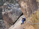
Idlehour trail view
Image

Coming to 1 S Harvard
Image

Drop in the drainage
Image

Rock bottom closeup
Image

1st of 3 waterfalls -30-40 ft. A red webbing with no rapide was left here by a previous party that was girth-hitched to a single branch on a bush. Little sign of rope wear, and no sign of further travel, so it was unclear if the previous party continued.

Image

2nd of 3
Image

3rd of 3(certainly > 100ft)
Image

Point of no return - Eaton
Image

Swim
Image

Esme canyon-I counted 5 drops but couldnt see how long the last one was
Image
User avatar
HikeUp
Posts: 3861
Joined: Thu Sep 27, 2007 9:21 pm

Post by HikeUp »

Great pictures AW. Big falls!

Is 8 minutes a long time or a short time for the climb up to the Telephone Trail?
User avatar
Taco
Snownado survivor
Posts: 6011
Joined: Thu Sep 27, 2007 4:35 pm

Post by Taco »

Esme looks cool. Folks do that as a canyoneering route on a regular basis, no?
User avatar
AW~
Posts: 2043
Joined: Mon Oct 01, 2007 12:00 pm

Post by AW~ »

HikeUp wrote: Great pictures AW. Big falls!

Is 8 minutes a long time or a short time for the climb up to the Telephone Trail?
It usually takes me at least twice as long. The soil was nice and compactable, and the use trail was in excellent condition. Summertime brings a dry/crumbly trail thats gutted....especially in the middle portion.
Taco wrote: Esme looks cool. Folks do that as a canyoneering route on a regular basis, no?
I dont know of anyone who has done it. Pretty much the only rappelling into Eaton I know of is people who have descended the Muir ravines.
User avatar
Taco
Snownado survivor
Posts: 6011
Joined: Thu Sep 27, 2007 4:35 pm

Post by Taco »

Harumph. It's on the list now. 8)
User avatar
Johnny Bronson
Posts: 179
Joined: Mon May 31, 2010 2:04 pm

Post by Johnny Bronson »

add it to the 10452395829058234905 list :P
User avatar
Hikin_Jim
Posts: 4686
Joined: Thu Sep 27, 2007 9:04 pm

Post by Hikin_Jim »

Johnny Bronson wrote: add it to the 10452395829058234905 list :P
Oh, the short list you mean. :wink:

HJ
User avatar
cougarmagic
Posts: 1409
Joined: Wed May 07, 2008 5:21 pm

Post by cougarmagic »

Nice trip AW.

Do you know of any access to the middle section of Eaton (middle of the technical route - the mile or so of hiking) from the fire road near Henninger?

Last time I was there, I chatted with two mountain bikers on the way up who said they were going to ride up to Esme Junction, then hike down "from the helicopter pad" on a trail they said utility workers used to access the water tunnel. I couldn't figure out what they were talking about.

They were not talking about the telephone trail - they very specifically talked about going into the water tunnel a short distance to check it out.

Unless there is another water tunnel near Idlehour??
User avatar
Taco
Snownado survivor
Posts: 6011
Joined: Thu Sep 27, 2007 4:35 pm

Post by Taco »

Hikin_Jim wrote:
Johnny Bronson wrote: add it to the 10452395829058234905 list :P
Oh, the short list you mean. :wink:

HJ
My summer list is growing. I can reach most of it by bicycle so it's cheap... just need rope now. Also, a harness that doesn't castrate me might be nice. :-)
User avatar
HikeUp
Posts: 3861
Joined: Thu Sep 27, 2007 9:21 pm

Post by HikeUp »

cougarmagic wrote: Last time I was there, I chatted with two mountain bikers on the way up who said they were going to ride up to Esme Junction, then hike down "from the helicopter pad" on a trail they said utility workers used to access the water tunnel. I couldn't figure out what they were talking about.
Just guessing CM, but they may have been refering to the helipad west of Esme Junction. On this ACME map, the helipad I refer to is A and they may have either been talking about descending ridge B or C. Just a guess.
User avatar
AW~
Posts: 2043
Joined: Mon Oct 01, 2007 12:00 pm

Post by AW~ »

The only way to get to the middle part is to walk down at a diagonal from just before Telephone flat..."Telephone trail ends at a flat area (Telephone Flat) in a saddle (34o12.18'N 118o5.49'W and elevation 2580ft) behind a promontory or ridge that juts out into Eaton Canyon. .... First look down the gully on the south side of the Flat; though steep this can be safely climbed and allows access to or exit from the middle section of the canyon" Its a descent on the spine of a certain ridge for a ways then into a gully then into Eaton creek....its got nothing to do with the helipad or utility workers....no bikes either 8)

There is the closed water tunnel down by pk1841, downhill of the helipad(thats an understatement), that is unlikely their destination...hmm..I dont know what tunnels they were talking about.
User avatar
AW~
Posts: 2043
Joined: Mon Oct 01, 2007 12:00 pm

Post by AW~ »

Johnny Bronson wrote: add it to the 10452395829058234905 list :P
Yeah, first he has to climb Muir
Image

or descend the main canyon...one of the drops...ending of drop is at bottom left of pic
Image
User avatar
cougarmagic
Posts: 1409
Joined: Wed May 07, 2008 5:21 pm

Post by cougarmagic »

AW wrote: though steep this can be safely climbed and allows access to or exit from the middle section of the canyon"
hmmm indeed...when Chris says "steep" it is best to believe it...
User avatar
Taco
Snownado survivor
Posts: 6011
Joined: Thu Sep 27, 2007 4:35 pm

Post by Taco »

Arright, sounds like a done deal. :-)
Post Reply