Jepson Peak by way of "Snaggle-Tooth" Couloir

Archived TRs for ranges in California.
Post Reply
User avatar
lilbitmo
Posts: 1092
Joined: Tue Mar 04, 2008 9:44 pm

Post by lilbitmo »

Another fun climb in the San Bernardino Mountains. Jeff Scofield (Yeti) called me on Thursday to ask if I wanted to do a couloir leading up the east face of the north ridge of Jepson Peak in the big draw or big bowl, call it what you want. Since Zach and I had already made plans to do Dobbs, Jepson and San G it was easy to talk us into switching from the south side of the mountain to the north side.

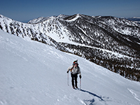
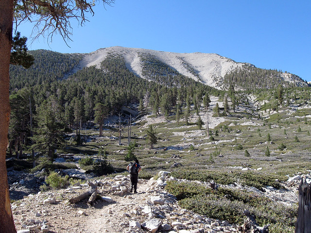
Knowing that it’s a big day and knowing that one of us had to be back by 6 PM Saturday night for a previous engagement, Jeff picked Zach and I up at my house at 3:15 AM, by 5:20 AM we were headed up the south fork trail. It was a mixed bag of Icy snow and dirt for the first two miles, and then at Horse meadows it became slightly thicker but still Icy and consolidated where the trail crosses the road to Poopout Hill up through the meadow and down the main trail. Being that we had started so early the snow was kind enough to stay firm enough to hold both Jeff and I until we reach the south side of South Fork Meadows at 7:15. By 9 AM we had made it up and over Christmas tree hill and made our way into the “Little Draw” or the bowl that separates Jepson and Little Charlton.

All three of us soon agreed that we wanted to do a line/couloir on the west face of the north ridge instead of the one on the opposite side of that same north ridge as it was a very clean line that we could see from where we came over Christmas tree hill and we didn’t know what we might find on the other side. Soon we were headed up the now aptly named “Snaggle-Tooth” Couloir (Jeff and I agreed to let Zach Name it as he was the first to suggest it) as it had some jagged rocks near the top where it met the ridge line and it also had a couple of dead trees at that point as well. The total distance up this route was somewhere in the 800 to 900 foot range, with 30 – 45 degree slope near the ridgeline.

Our Route up Snaggle-Tooth
Image

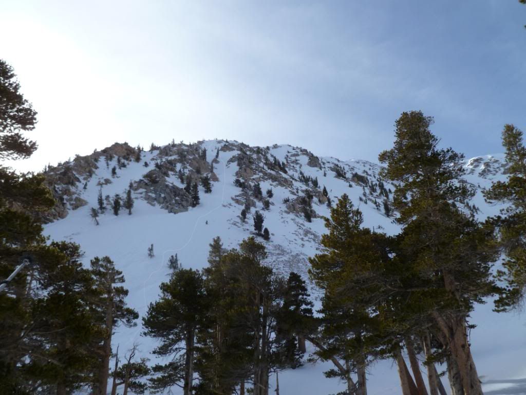
Once on top of the ridge it was another 800 feet to traverse to the summit. The ridge presented two sketchy spots with mixed ice that was nearly impossible to kick steps into so it was time consuming but we found ourselves on the summit by 11:30 AM and being blasted by winds in the 35+ range. After the celebratory summit pictures we circled northwest towards Charlton, dropped into that saddle, then dropped back into the bowl that is the “little draw” put our snow shoes back on as it was getting warm fast and that area had very little of the wind we encountered on the ridge and the summit.

Once we were back on the north side of south fork meadows we packed in the snowshoes and made great time, but at the west side of Poopout Hill we began to sink up to our knees as there we so many different routes leading down that hill that we end up taking the wrong one and paid the price of post holing for a half hour until we came across the road again, from there it was just a matter of slugging through the thin slushy snow and mud back to the car at the trailhead.

Other than one guy in the parking lot, one hiker on the east side of South Fork Meadows we did not see anyone else until just before the Poopout Hill (on the decent – four campers were heading up) all day. Then we ran into maybe 10 people in the last mile before the parking lot playing in the muddy snow and slush with sleds and snow shoes.


Rest of My Pictures Here
User avatar
snmtbaldy
Posts: 66
Joined: Tue Nov 24, 2009 7:01 pm

Post by snmtbaldy »

Congratulations Jeff,Patrick,and Zach !!!
I enjoyed the trail report very much. You guys are hardcore mountaineers.
Looking forward to hiking with you soon.
Shin.
User avatar
Hikin_Jim
Posts: 4686
Joined: Thu Sep 27, 2007 9:04 pm

Post by Hikin_Jim »

Nice one, guys!

HJ
User avatar
norma r
Posts: 707
Joined: Thu Nov 06, 2008 4:22 pm

Post by norma r »

Snaggle-tooth looked fun! Nice job guys! But boilerplate ice on top in early Feb? Say it isn't so!! :cry: Who pissed-off the Snow God's? Baldy et al looked purdy from Jepson but the north face of San Jacinto looked weak. It appears SGW above 8200' is really the only decent place for snow in So Cal right now.

Now i lay me down to sleep, i pray for snow to fall (at least) 10 feet deep...
User avatar
Hikin_Jim
Posts: 4686
Joined: Thu Sep 27, 2007 9:04 pm

Post by Hikin_Jim »

norma r wrote: Now i lay me down to sleep, i pray for snow to fall (at least) 10 feet deep...
:lol:

I think a good three feet would be just fine. Enough of this warm weather already.

HJ
User avatar
jjpicts
Posts: 18
Joined: Wed Feb 03, 2010 2:56 pm

Post by jjpicts »

[quote="
Other than one guy in the parking lot, one hiker on the east side of South Fork Meadows we did not see anyone else until just before the Poopout Hill (on the decent – four campers were heading up) all day. quote]

Hey think I was following you Sat. all the way to Christmas tree Hill, But we went strait over to the N. chute of San G.. Conditions were similar, a few drifts of powder in the chute and Iced snow from about half way up. I could sink my Ice axe shaft in all the way, it was soft snow underneath the crust, but if it starts to warm up that slope is set to slip.
my photos are here
https://picasaweb.google.com/1170959980 ... Chutes2511#
User avatar
lilbitmo
Posts: 1092
Joined: Tue Mar 04, 2008 9:44 pm

Post by lilbitmo »

Nice work JJpicts and company, very nice photos, those sunset shots were fantastic, we saw that same color on the drive home - was explaining to the other guys that with a tripod and slow shutter speed on the camera you can make that kind of sunset look surreal.

Quick question, did you go up the big draw to the summit of San G and/or did you go up the west face of the north east ridge?

What time did you leave the trialhead? You must have just missed us. :(
User avatar
simonov
Posts: 1087
Joined: Tue Nov 27, 2007 5:44 pm
Location: Reno, NV
Contact:

Post by simonov »

Dudes, Ingrid are going up for an overnight on Saturday. We were hoping we wouldn't need snowshoes. Is that not the case?

Also, about routes: we intend to stay at Dry Lake. I notice during the winter most folks go straight up Christmas Tree Hill from South Fork Meadow. Is that a good route to Dry Lake?
Nunc est bibendum
User avatar
Hikin_Jim
Posts: 4686
Joined: Thu Sep 27, 2007 9:04 pm

Post by Hikin_Jim »

Simonov,

Going up Christmas Tree Hill gets you into the bowls and such (Big Draw), but isn't a good way to get to Dry Lake. The best winter route to Dry Lake is to just follow the outlet stream all the way up from S Fork ("Slushy") Meadows. Generally staying on the right hand side seems best, but whatever works.

HJ
User avatar
James
Posts: 79
Joined: Thu Feb 04, 2010 3:28 pm

Post by James »

Congrats and nice TR! Looks like a fun route.
User avatar
JEFFSCOF
Posts: 62
Joined: Thu Jan 03, 2008 2:56 pm

Post by JEFFSCOF »

Patrick and Zach I had a wicked awesome time, with awesome people on a unbelievable route!
Patrick I might blow up two of the pics you took that day awesome. My pics are below:

https://picasaweb.google.com/Jeffscof/J ... sternRoute#

SanG Yeti
User avatar
jjpicts
Posts: 18
Joined: Wed Feb 03, 2010 2:56 pm

Post by jjpicts »

lilbitmo wrote: Nice work JJpicts and company, very nice photos, those sunset shots were fantastic, we saw that same color on the drive home - was explaining to the other guys that with a tripod and slow shutter speed on the camera you can make that kind of sunset look surreal.

Quick question, did you go up the big draw to the summit of San G and/or did you go up the west face of the north east ridge?

What time did you leave the trialhead? You must have just missed us. :(
Thank's,we left around 5:50 and got back around 5:30. And yes we went up the west side of the N. ridge, same place I took the shot of our butt track. I avoided the Big Draw cause a friend had been up on Jepson the week before and mentioned that the cornice over the Big Draw had a long crack in it. I never went to check it out myself. The snow in the chute we went up was frozen from about a third of the way down, but I could plunge my Ice axe into it all the way down. Just soft powder under the top inch or so of snow, so I figure if it warms up any time soon it will probably slide.

Yes it was nice to have such a awesome sunset after a fun day on the
mountain.

John
User avatar
Zach
Posts: 522
Joined: Sun Jan 04, 2009 4:25 pm

Post by Zach »

Simonov: I doubt snow shoes will be necessary to dry lake. That trail is so hard packed from all the travel. Also, HJ is definitely right about the route. Dry Lake is best accessed by staying left after SFM. Personally, I think the area right between the two draws is about a billion times more scenic than dry lake... and probably no other people. This was my first time in that area during winter and it was AMAZING. Cresting xmas tree hill and seeing the big and little draws with jepson smack in the middle was really cool. If you camp near there just be mindful of the avy danger. Have fun!
User avatar
simonov
Posts: 1087
Joined: Tue Nov 27, 2007 5:44 pm
Location: Reno, NV
Contact:

Post by simonov »

Thanks, Zach.

We were considering snowshoes because you guys said you used them around Poopout. REI is having a winter sale on Friday and we might pick some up.

Yeah, I'd love to camp up there below Big Draw, which even in the summer is in my opinion the most scenic part of the San Gorgonio Wilderness, but I am a little concerned about avalanches.

Image

If anyone else would like to join us this weekend, we wouldn't mind company. We will be staying at Angelus Oaks on Friday night and intend to get a very early start on Saturday.
Nunc est bibendum
User avatar
Johnny Bronson
Posts: 179
Joined: Mon May 31, 2010 2:04 pm

Post by Johnny Bronson »

You guys had a blast!Sounds like a super fun trip!Beautiful pics and tr! :thumbup: :D
Post Reply