
Hello All,
I am hoping to do a canyoneering trip to Allison Mine on 1/22/2011. My group would hike in along Allison Gulch and the old mining trail and enter the canyon at the mine. (see map for return path).
http://mapper.acme.com/?ll=34.25516,-11 ... Baldy%20CA
I know we will have to cross the East Fork at least twice on the way to the mine (and on the way back). Can anyone offer an update on what the water flows are like after the storms? Also, how wet can I expect the canyon to be?
Thank you in advance,
Allison Mine
-
Johnny Bronson
- Posts: 179
- Joined: Mon May 31, 2010 2:04 pm
I would say,its a safe bet,that its more than normal water flow.Expect to be swimming,Especially with the recent weather and mass run off from higher elevations.
-
davantalus
- Posts: 203
- Joined: Mon Jun 08, 2009 9:09 am
I went up the East Fork last weekend. Went all the way up to the Narrows. The water isn't too bad. I'm 6'3" and at the very worst it came up to my crotch. For an experienced canyoneer the crossings before the gulch are child's play.
I can't speak for the canyoneering section but the water flowing out of Allison had some decent volume so you could be in for a lot of fun!
I would suggest entering and leaving via Allison Gulch. There does exist a method of reaching the mine via Heaton Saddle but I would definitely not recommend it with ropes and gear.
You may well be the first people up to the mine since the rains and since this is your first post I'll issue two warnings about the trip:
• It's easy to miss the trail where it veers up the mountain out of the gulch. Mark it on a GPS before the trip. (I didn't and ended up climbing some... fun... slopes)
• There are a few wash outs up towards the mine. Use extreme caution on these since they will have been further eroded. (since you'll have the ropes, it may even be worth tying in, at least until you know if they're stable)
Have you seen Chris Brennen's beta? Again, I'd advise against the loop. http://www.dankat.com/advents/almine.htm
-
Ze Hiker

- Posts: 1432
- Joined: Mon Jul 28, 2008 7:14 pm
got a map/gps track in here you could look at to see where trail starts out of the gulch.
http://socalhikes.com/2009/01/east-fork ... lat-trail/
http://socalhikes.com/2009/01/east-fork ... lat-trail/
-
Dominik
- Posts: 17
- Joined: Tue Jan 11, 2011 12:44 am
Thank you for everyone's input.
I will be doing the canyon with six intermediate level canyoneers. Sounds like 3/2 mm wet suits and neoprene socks are a must. I will also assume that after the storm we will have to build natural anchors at each rap.
Ze & Davantalus, thanks for the links. Great resource. I read them both before hiking the trail back in September. As we know, things change with rain and it's best to ask.
Does anyone know if there will be "heavy water" rappels? Turbulent holes at the end of the rap?
-
davantalus
- Posts: 203
- Joined: Mon Jun 08, 2009 9:09 am
Good plan, river was pretty chilly!Dominik wrote: Sounds like 3/2 mm wet suits and neoprene socks are a must.
Taco might know.Dominik wrote: Does anyone know if there will be "heavy water" rappels? Turbulent holes at the end of the rap?
Seriously though, you might want to bring an ascender combo for the first person down. (Do canyoneers ever use the frog system as a backup? Is it possible to climb back up against the force of a waterfall using ascenders?)
-
cougarmagic

- Posts: 1411
- Joined: Wed May 07, 2008 5:21 pm
Welcome Dominik! I'm glad you're getting some good input here. I figured these guys would have the 411 for ya!
-
Dominik
- Posts: 17
- Joined: Tue Jan 11, 2011 12:44 am
-
Dominik
- Posts: 17
- Joined: Tue Jan 11, 2011 12:44 am
Canyoneers typically don't carry the frog system but just about everyone has a means to ascend. I carry two Ropeman 2 but there are other light mechanical ascenders out there on the market. In a pinch, I do have material to ascend via prusiks.davantalus wrote: Seriously though, you might want to bring an ascender combo for the first person down. (Do canyoneers ever use the frog system as a backup? Is it possible to climb back up against the force of a waterfall using ascenders?)

-
Zach

- Posts: 522
- Joined: Sun Jan 04, 2009 4:25 pm
Looking forward to the TR! Be safe and have fun.
-
turtle

- Posts: 152
- Joined: Wed Jan 27, 2010 11:35 am
As of April the trail to the mine from Heaton Saddle was actually in fair shape -- certainly passable -- and Elwood made it even better with some trimming. Unless you think it's grown in substantially since then, I'd recommend that route, if only for variety. Though that does mean you'd potentially hit the East Fork sight unseen, committed to going downward. You'd want to get a good look at the river (from near the parking lot) before heading up and around the loop.davantalus wrote: I would suggest entering and leaving via Allison Gulch. There does exist a method of reaching the mine via Heaton Saddle but I would definitely not recommend it with ropes and gear.
-
Dominik
- Posts: 17
- Joined: Tue Jan 11, 2011 12:44 am
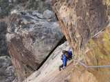
I am happy to say that we had relatively low water levels when we got to Allison Gulch. East Fork is still at about knee deep level. Warmer air temps made being wet a non-issue. Despite the fact that it is winter, the hike up to the mine got pretty hot. The trail can at times be difficult to follow.
My group of seven had a great time exploring the mine and the canyon. We were being filmed for an upcoming documentary about canyoneering called, Gorging.
http://www.dfsfilms.com/Gorgingmovie/
Thank you all for your feedback on trail condition.
Here is a link to photographs I took.
http://dominikn.smugmug.com/Landscapes/ ... 3796_fd5zT
-
cougarmagic
- Posts: 1411
- Joined: Wed May 07, 2008 5:21 pm
Nice Dominik! Sounds like it was a great day.
Where did you find the deer bones? 8)
Where did you find the deer bones? 8)
-
Dominik
- Posts: 17
- Joined: Tue Jan 11, 2011 12:44 am
Cougarmagic,cougarmagic wrote: Where did you find the deer bones? 8)
I found the bones about 1/4 mile up the gulch. I thought it may interest you hence the photo.
There were bear scats in the area as well but they were about two to three months old.
-
davantalus
- Posts: 203
- Joined: Mon Jun 08, 2009 9:09 am
Good light. Looks like it was a great day to shoot!
How were the cameras being kept dry?
How were the cameras being kept dry?
-
Dominik
- Posts: 17
- Joined: Tue Jan 11, 2011 12:44 am
I was shooting with the dSLR which I simply kept in a camera bag inside of my backpack. Only tricky thing was keeping the lens dry from the waterfall mist.davantalus wrote: How were the cameras being kept dry?
Video camera was kept in a more elaborate contraption. I don't know the name or brand of the manufacturer, but it served as an over-sized plastic sleeve with double velcro hatches to get access to the controls. With the low flows we experienced, it was not an issue.