1-22-2011 Ontario Peak Area

TRs for the San Gabriel Mountains.
Post Reply
User avatar
rokclimbr
Posts: 124
Joined: Mon Jan 03, 2011 5:32 pm

Post by rokclimbr »

Lately the night before a hike, climbing trip, adventure, etc... I have been having a hard time falling asleep I am so excited to get out. So last night I was up till after midnight thinking about all the posibilities today would bring. My alarm went off @ 6:20 and I jumped out of bed (good luck getting me out of bed that early on a work day) my pack was already packed, my lunch was made all I had to do was throw on some clothes and skidadle out the door :D

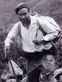
It was pretty chilly when I got to the Stoddard Peak parking lot, I left my jacket on and dug out my 2nd favorite beanie and cruised up the fire road. At the .75 mile mark I reached the gate and .72 miles after that I was at Cascade Canyon!

The hike up the canyon was crazy to say the least. I have never seen so many log jams above and below waterfalls with hundreds of saplings growing amongst the chaos. It was an epic bush-wack to get up the canyon. As I gained altitude there were huge burned trees that had fallen across the canyon, some were low enough that you could climb over them, others you had to get on your hands and knees and crawl underneath. Either way by the time I made it a mile I was covered in soot.

got some soot on my face, my shirt and trousers were covered in it!

At the first fork I hung a right and discovered this old snag covered in ladybugs! There were thousands of them all hibernating.


A little past this fork I discovered that there are some amazing cliffs up in Cascade Canyon, with some old routes from the 80's.

I had brought my climbing gear in the hopes of throwing a rope off the top and doing a bit of rope soloing with my mini Traxion. I spied a nice route with a large tree right at the lip with a fairly straightforward approach up the side. I was getting psyched to climb the route and decided to go a bit further up canyon to check out some more lines. As soon as I had walked about 15 meters up canyon a chunk of rock, about the size of a toaster, broke loose and bounced down the rock face, straight down my intended route! It crashed into a few trees at the bottom and exploded when it hit a large boulder. At that point I decided maybe I would hold off on the soloing seeing as no helmet is really going make a toaster sized block feel like a pebble and I was alone with no cell reception. This cliff wasn't going anywhere plus I had brought my ice axe just in case I found some snow. So I decided to keep pushing and see if I could find some snow.

I stashed my climbing gear in a cave, no sense in lugging it up the mountain if I wasn't going to use it. Plus my pack weighed about 40lbs and would just slow me down. After I ditched the rope, shoes, harness and rack I felt like I was floating :P

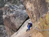
I came to another fork, I was torn go left or go right. Right looked a little easier but with more vegetation, the left looked steeper but looking at the map it looked like it was a longer route to the ridge-line, so naturally I chose left. I made the right choice, I found a nice 10-12 meter dry granite waterfall that I climbed up, probably about 5.5 or so. A little spooky but it felt nice to be on some vertical rock.

I stopped for lunch on a nice outcropping overlooking the valley and grubbed out on my puny sandwich, I was still hungry but knew I'd need my Cliff Bar for later.

What a nice spot to eat lunch!
I traversed the hillside and gained the saddle and man what a view! Absolutely stunning! But I still had a little further to go, earlier I had spied a nice looking peak and I wanted to bag it.

After some 4th classing and scrambling I summited! Elevation 6,615ft! I am not sure of the name anyone got any idea? (Not sure how accurate that is, my GPS was freaking out today at one point it said I had lost 30 feet when I had been hiking for almost a mile and the map showed a gain of almost 1,000 feet, weird...) Anyways the summit was awesome, I could see Claremont Peak, Mt San Bernardino, Mt San Gorgonio, Mt San Jacinto, Catalina, Mt Wilson, Mt Baldy & Ontario Peak!

Mandatory summit shot

view to the east

view to the south
On the way down I purposefully hiked down a rather large snow patch (snow level was about 6,000 feet in small patches on north facing hillsides only) and broke out my new ice axe, I found a good spot to practice my self arrest. That REI Yeti axe sure does bite!

The descent was routine, very steep and almost no sun (Cascade Canyon is in the shade all day long, might be a good place to find ice when it gets colder...) I picked up my gear on the way back down and by 2:30 I was back at the car. It was about 8 miles total, 6,000 feet gained and lost and I saw zero people the entire day!
User avatar
Taco
Snownado survivor
Posts: 6010
Joined: Thu Sep 27, 2007 4:35 pm

Post by Taco »

Very cool. I didn't go up there last time because of how much that bushwhack sucks!

That peak does not have a name, as far as I know. A friend of mine talked to me about it a while ago. It's got a neat profile when viewed from Sunset Peak and other areas.

Thanks for posting this!
User avatar
obie
Posts: 339
Joined: Thu Jan 07, 2010 9:36 pm

Post by obie »


It was an epic bush-wack to get up the canyon.
Good one.

Took a look at that area last year and figured it was bloody work to hack through that.
User avatar
rokclimbr
Posts: 124
Joined: Mon Jan 03, 2011 5:32 pm

Post by rokclimbr »

The peak had an old metal marker on top that said VH 17, so I guess we'll call it Peak VH17 then :)
User avatar
Johnny Bronson
Posts: 179
Joined: Mon May 31, 2010 2:04 pm

Post by Johnny Bronson »

Good stuff Isaac.Some rough bushwacking lol
Great trip report!Sweet pics also.

But man please be extra careful trying to rope solo "choss piles" especially in the san gabs.From personal experience ,even with a helmet you cant be too safe alone!There is usually good size rocks falling down when "rock climbing and san gabs" are in the same sentence lol.Its quite adventurous climbing usually,but not worth the risk to rope solo imo.


Not to thread drift,but maybe to give you some alternatives if you are truly itching to get some rope soloing locally in the san gabs with the least of choss.There is one spot that is decent fun called Peace crag(Swasticrag) going up rt 39.It is still in the san gabs,so always expect loose rocks but this crag is decent from my personal experiences.

Taco put up some routes awhile ago and we cleaned up some graffiti,loose rocks over time etc etc to make it more safe/enjoyable.You can also lead the routes if you like a bit of excitement,but,there is some questionable fixed pro from previous ascents but the routes on the topos can be top roped no problem.5 minute approach from parking to the climb.

check out the beta from tacos page
http://www.summitpost.org/swasticrag/632066
http://www.summitpost.org/johnny-coveri ... 7/c-632066
Cleaning/covering graffiti while on lead :P
User avatar
Sewellymon
Posts: 97
Joined: Tue Feb 12, 2008 8:55 pm

Post by Sewellymon »

VERY cool you found the Cascade Canyon crags. My friends who developed lots of the routes there ('78, '79) were excellent climbers and were psyched with the fun they were having. But the approach is a hump (i turned back the one time i tried- my wife got sick of the bushwhack...). So the routes fell into disuse almost as soon as they were put up....
User avatar
Taco
Snownado survivor
Posts: 6010
Joined: Thu Sep 27, 2007 4:35 pm

Post by Taco »

Next time I head up there, I'll chop a trail. I won't chop an entrance... but I'll make it easy if you know where to go. Gnaw mean?
User avatar
rokclimbr
Posts: 124
Joined: Mon Jan 03, 2011 5:32 pm

Post by rokclimbr »

@ Taco - when you head up, let me know I'll tag along and help. There is a very faint trail, it kind of switches sides of the canyon. When it disappears check the other side. However the trail is indeed thrashed so a bit of work would help. Not sure how long it would last though... Maybe after a bit of work we could tie in and get some FA's :)?

@ Johnny - I should clarify I wasn't planning on rope soloing on lead rather I just toss a rope off the top and climb up. No fall potential and I always build the anchor to minimize swing too so not to saw through my 11.3mm static rope. On a side note: Dont' listen to Jeff Long's book The Wall on the way to the trailhead, talk about spooky :)
Thank you for the beta on Peace Crag, let's check it out!

@Sewellymon - I got some good beta from Rick Shull, no him?
User avatar
Taco
Snownado survivor
Posts: 6010
Joined: Thu Sep 27, 2007 4:35 pm

Post by Taco »

Sure thing. We've got some work to do in the area.
User avatar
Sewellymon
Posts: 97
Joined: Tue Feb 12, 2008 8:55 pm

Post by Sewellymon »

rokclimbr wrote:
@Sewellymon - I got some good beta from Rick Shull, no him?
Hi- the FA guys were Keith Cunning and Ed Kaufer ("the Uplanders").
There were a score of "Uplanders" who all climbed together in the late 70's- was Rick one of them?
User avatar
Johnny Bronson
Posts: 179
Joined: Mon May 31, 2010 2:04 pm

Post by Johnny Bronson »

gotcha Isaac!Sounds good!
Taco wrote: Sure thing. We've got some work to do in the area.
Lets get some cleaning and climbing in,You guys down to go on a weekday sometime in the upcoming weeks?
I have some new gear to test out also.

Does anyone else want to join and get some super chill rock climbing in?(just need a HELMET,harness and shoes,top rope)
Not to thread drift,but since we are inviting Isaac,throwing this out in the public for anyone to join.So no one gets butt hurt =D

Private message me or Taco and we will setup a very chill top rope session day in the beautiful San Gabs :)
User avatar
rokclimbr
Posts: 124
Joined: Mon Jan 03, 2011 5:32 pm

Post by rokclimbr »

Give me a few more days to forget the approach and I'll be down to go up there again. Although with more folks going I won't have to carry so much gear :P
Post Reply