Trip planning, history, announcements, books, movies, opinions, etc.
Tim
Posts: 560 Joined: Tue Apr 08, 2008 8:55 pm
Post
by Tim Tue Jan 19, 2010 5:24 pm
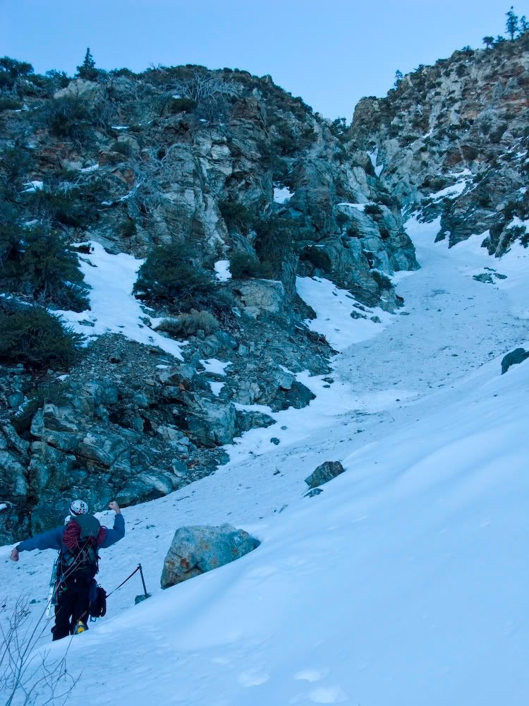
A picket and a hell of a lot of rope. Must have been doing some training? My guess is Lightning Couloir and we're looking at that side gully that goes up to Miner's Bowl?
Tim
Posts: 560 Joined: Tue Apr 08, 2008 8:55 pm
Post
by Tim Tue Jan 19, 2010 5:50 pm
Zé wrote:tinaballina wrote:i don't think Ze is allowed to guess, he knows the whole mountain range like the back of his hand.
lol no way. maybe the peaks, but no stinking coulours like Taco!
Zé has come a long way:
https://eispiraten.com/s ... ight=#4521
To this day he still doesn't know how to read a map or use a compass. He just walks in a straight line to each peak, no matter what god awful thorny brush is in the way
Taco
Snownado survivor
Posts: 6059 Joined: Thu Sep 27, 2007 4:35 pm
Post
by Taco Tue Jan 19, 2010 6:32 pm
Tim wrote:A picket and a hell of a lot of rope. Must have been doing some training? My guess is Lightning Couloir and we're looking at that side gully that goes up to Miner's Bowl?
Close... different peak, though.
tinaballina
Posts: 182 Joined: Thu Jun 18, 2009 11:28 am
Post
by tinaballina Wed Jan 20, 2010 11:38 am
Tim wrote:Zé wrote:tinaballina wrote:i don't think Ze is allowed to guess, he knows the whole mountain range like the back of his hand.
lol no way. maybe the peaks, but no stinking coulours like Taco!
Zé has come a long way:
https://eispiraten.com/s ... ight=#4521
To this day he still doesn't know how to read a map or use a compass. He just walks in a straight line to each peak, no matter what god awful thorny brush is in the way
And here i thought Zé looked for the steepest routes possible to each peak, which means walking through every bush, thorn and scree possible.
Ze Hiker
Posts: 1432 Joined: Mon Jul 28, 2008 7:14 pm
Post
by Ze Hiker Wed Jan 20, 2010 3:45 pm
straightest, steepest. usually both
tinaballina
Posts: 182 Joined: Thu Jun 18, 2009 11:28 am
Post
by tinaballina Wed Jan 20, 2010 3:51 pm
Zé wrote:straightest, steepest. usually both
thats what she said....lol...sorry that was wide open.
AW~
Posts: 2077 Joined: Mon Oct 01, 2007 12:00 pm
Post
by AW~ Wed Jan 20, 2010 4:03 pm
Zé wrote:what peak is this?
I dont know, but this is the upper Big T...I'll go with Iron Mtn
edenooch
Posts: 504 Joined: Fri Jul 03, 2009 7:42 pm
Post
by edenooch Wed Jan 20, 2010 5:07 pm
Zé wrote:where is this taken from?
so where the heck was the pic taken!?!?!
Ze Hiker
Posts: 1432 Joined: Mon Jul 28, 2008 7:14 pm
Post
by Ze Hiker Wed Jan 20, 2010 5:13 pm
AW wrote:Zé wrote:what peak is this?
I dont know, but this is the upper Big T...I'll go with Iron Mtn
close, but nope
Ze Hiker
Posts: 1432 Joined: Mon Jul 28, 2008 7:14 pm
Post
by Ze Hiker Wed Jan 20, 2010 5:13 pm
edenooch wrote:
[/color]so where the heck was the pic taken!?!?!
twin peaks
Ze Hiker
Posts: 1432 Joined: Mon Jul 28, 2008 7:14 pm
Post
by Ze Hiker Wed Jan 20, 2010 5:14 pm
tinaballina wrote:Zé wrote:straightest, steepest. usually both
thats what she said....lol...sorry that was wide open.
golf clap
AW~
Posts: 2077 Joined: Mon Oct 01, 2007 12:00 pm
Post
by AW~ Wed Jan 20, 2010 5:27 pm
Zé wrote:AW wrote:I'll go with Iron Mtn
close, but nope
OK, Rabbit Peak is next
AW~
Posts: 2077 Joined: Mon Oct 01, 2007 12:00 pm
Post
by AW~ Wed Jan 20, 2010 5:42 pm
named peak....those sides of the ridges are quite steep
Mike P
Posts: 1005 Joined: Tue Oct 02, 2007 10:48 pm
Post
by Mike P Wed Jan 20, 2010 5:44 pm
Etiwanda Peak?
AW~
Posts: 2077 Joined: Mon Oct 01, 2007 12:00 pm
Post
by AW~ Wed Jan 20, 2010 5:56 pm
nope....I forgot to say the view is looking south. I dont have another picture of the moutain, but here is one of the drainage just over the horizon(going left to right in the previous picture)..this photo is looking east with the mountain in question straight ahead & on the right side of the picture.
Taco
Snownado survivor
Posts: 6059 Joined: Thu Sep 27, 2007 4:35 pm
Post
by Taco Wed Jan 20, 2010 7:36 pm
Someone has to guess my picture or this thread gets locked.
Ze Hiker
Posts: 1432 Joined: Mon Jul 28, 2008 7:14 pm
Post
by Ze Hiker Wed Jan 20, 2010 7:43 pm
TacoDelRio wrote:Someone has to guess my picture or this thread gets locked.
one of those colours that a rock fell on you 8) WIN
Ze Hiker
Posts: 1432 Joined: Mon Jul 28, 2008 7:14 pm
Post
by Ze Hiker Wed Jan 20, 2010 7:50 pm
no idea AW!!!!
but imma gonna take a wild guess.... Granite
Ze Hiker
Posts: 1432 Joined: Mon Jul 28, 2008 7:14 pm
Post
by Ze Hiker Wed Jan 20, 2010 7:55 pm
TacoDelRio wrote:Someone has to guess my picture or this thread gets locked.
damn kids on power trips!
actually now I think it is mine gulch on baden powell
AW~
Posts: 2077 Joined: Mon Oct 01, 2007 12:00 pm
Post
by AW~ Wed Jan 20, 2010 8:50 pm
Zé wrote:no idea AW!!!!
but imma gonna take a wild guess.... Granite
Yup!
Ze Hiker
Posts: 1432 Joined: Mon Jul 28, 2008 7:14 pm
Post
by Ze Hiker Wed Jan 20, 2010 9:13 pm
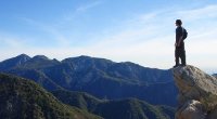
two part question
1) what is this a photo of
2) what peak is it taken from?
Elwood
Posts: 617 Joined: Fri Aug 15, 2008 5:23 pm
Post
by Elwood Wed Jan 20, 2010 10:13 pm
1) Triplets
Taco
Snownado survivor
Posts: 6059 Joined: Thu Sep 27, 2007 4:35 pm
Post
by Taco Wed Jan 20, 2010 11:59 pm
Zé wrote:TacoDelRio wrote:Someone has to guess my picture or this thread gets locked.
one of those colours that a rock fell on you 8) WIN
Surprisingly, you are wrong.
Telegraph Peak's long white streak, the West Face Couloir.
Ze Hiker
Posts: 1432 Joined: Mon Jul 28, 2008 7:14 pm
Post
by Ze Hiker Thu Jan 21, 2010 6:33 am
Elwood wrote:1) Triplets
2) Mt. Sally (?)
1) Yes
2) Mt Wilson - but close enough I think. hard to tell since i zoomed in.
Elwood
Posts: 617 Joined: Fri Aug 15, 2008 5:23 pm
Post
by Elwood Thu Jan 21, 2010 7:19 am
Do we need a ruling from the grand poo-bah, or is this answer close enough for a post?
Ze Hiker
Posts: 1432 Joined: Mon Jul 28, 2008 7:14 pm
Post
by Ze Hiker Thu Jan 21, 2010 9:44 am
oh close enough to go next. i'm gonna refrain from answering this one...
AW~
Posts: 2077 Joined: Mon Oct 01, 2007 12:00 pm
Post
by AW~ Thu Jan 21, 2010 1:00 pm
hmm...dont know. My 2 guesses would be either somewhere near the San Gabriel river-East fork or Big Rock creek?
platypii
Posts: 55 Joined: Mon Jan 26, 2009 4:58 am
Post
by platypii Thu Jan 21, 2010 1:15 pm
Just below Allison Mine?