Bad Altitude: Cottonwood Lakes 11/6-11/7/09

Archived TRs for Sierra Nevada ranges.
Post Reply
User avatar
cougarmagic
Posts: 1409
Joined: Wed May 07, 2008 5:21 pm

Post by cougarmagic »

Jane and I finally got to do a trip we had talked about all summer, but never were able to schedule. Neither of us had been here before. We were worried about low temps, so we brought a lot of extra clothing and nervously watched the forecast, which claimed that nights would be in the low twenties.

When picking up our permits,the nice lady at the ranger station said to us with that "you two are crazy" expression "Nobody's up there anymore". But assured us that aside from a few small patches of ice, the trails should be clear, and the bears settled down. Canisters are not required after 10/31, though still recommended. We planned to hang our food, provided there were trees nearby - otherwise, eat a big dinner and hope for the best. :D

The Cottonwood Lakes trail starts at 10k', and goes up mildly from there. Acclimatizing? We don't need no stinking.....uh, wait, where did these gnomes come from, and why are they ice climbing inside my brain?? Our campsite was at 11,200' and the headache floored me, especially when I moved my head. I downed some aspirin and a bunch of water, still had a restless night, but woke up feeling much better. And, the weather was pretty mild. Neither of us were cold, and except for some wind at night, it was very calm.

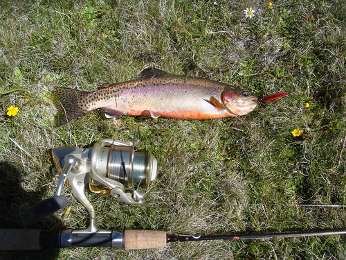
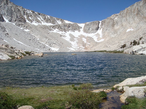
We managed to make a loop, and see all the lakes in the area except for Muir and Hidden, which were more out of the way. Jane knew this already, but I learned how cross country travel in the Sierras is so much easier than it is in the San Gabriels. She kept looking at the map and casually saying "we can just cut across here, no problem." It was freaking me out, until we did a couple of shortcuts that were easier than some trails I know! Lots of fisherman's use trails in the area helped.

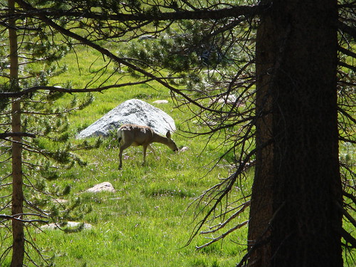
Though it's cold, there is still active wildlife up there. We saw two foxes, a gigantic snowshoe hair (swear to god, it was the size of a small dog), saw some cougar tracks and scat, and heard the weirdest sound around the lake which we later figured out were Sage Grouse. It sounded like a cross between an owl and a bullfrog, and was reverberating off the walls of the lake, making it extremely loud and very eerie!

Image
Image
Image
Image

Rest of the pics:
http://s484.photobucket.com/albums/rr20 ... =slideshow

I want to see this place in summer!
User avatar
Ze Hiker
Posts: 1430
Joined: Mon Jul 28, 2008 7:14 pm

Post by Ze Hiker »

wow nice! what the heck is that 3rd picture?!
User avatar
Funyan005
Posts: 203
Joined: Tue Apr 01, 2008 11:17 pm

Post by Funyan005 »

Looks like a blast, wonder if I can get up there before the real snow comes
User avatar
Winston
Posts: 50
Joined: Wed Jun 24, 2009 1:58 pm

Post by Winston »

I went July 4th weekend, and it was beautiful. I saw a pair of coyote, and some deer. Lots of mosquitos though. Caught some California Golden Trout at Cottonwood Lake #3 while on my way to Mt. Langley. I liked it enough that I'll probably make this place a yearly trip.

Image

Image

Image

Last pic is Cottonwood Lake #4. Old Army Pass zig zags up the bowl.

More pics here.

http://www.flickr.com/photos/20856672@N ... 111356394/
User avatar
cougarmagic
Posts: 1409
Joined: Wed May 07, 2008 5:21 pm

Post by cougarmagic »

wrote:wow nice! what the heck is that 3rd picture?!
Ice on the lake surface!!
User avatar
Ze Hiker
Posts: 1430
Joined: Mon Jul 28, 2008 7:14 pm

Post by Ze Hiker »

why are the lines black?
User avatar
cougarmagic
Posts: 1409
Joined: Wed May 07, 2008 5:21 pm

Post by cougarmagic »

Winston wrote: Last pic is Cottonwood Lake #4. Old Army Pass zig zags up the bowl.
Wow - I saw what looked like it might be a trail there, but dismissed it because it looked so crazy. Do people still use that? My GPS labelled the South Fork trail as "infrequently maintained", but it was great, and a really beautiful spot.

That is an amazing trout - nice catch!

On edit - oh, I guess you did go up there! haha
User avatar
cougarmagic
Posts: 1409
Joined: Wed May 07, 2008 5:21 pm

Post by cougarmagic »

Ze - it was little plates of ice that would re-freeze at night, I think. the lines are thinner ice, where you can see through to the water still.
User avatar
Winston
Posts: 50
Joined: Wed Jun 24, 2009 1:58 pm

Post by Winston »

Thanks! The trout were pretty easy to catch; they must have been really hungry.

Yeah, Old Army Pass is not maintained now, but it's in decent shape. I think lots of people still use it since it's shorter than taking New Army Pass, which is the trail that is now maintained. But it can be dangerous because the snow stays on portions of the trail well into summer. I think a woman died on it the week after I went up. There was one portion that was pretty sketchy due to the snow, but it could be avoided with a short class 3 climb, which I did on the way up. However, on the way back down, I saw a marmot run across the snow and thought that it couldn't be that bad. Ended up being pretty scary. I had an ice axe, but no crampons and poor shoes for kicking steps into the snow. Picked up a black toenail.
User avatar
edenooch
Posts: 504
Joined: Fri Jul 03, 2009 7:42 pm

Post by edenooch »

are langley and cirque peaks accessible?
User avatar
Taco
Snownado survivor
Posts: 6010
Joined: Thu Sep 27, 2007 4:35 pm

Post by Taco »

Eric, yep. Super easy access to Cirque.

Nice pics! I too got a killer headache when I went up there, but I didn't wake up feeling better.
User avatar
EnFuego
Posts: 677
Joined: Mon Dec 15, 2008 11:14 am

Post by EnFuego »

Nice TR and beautiful pictures. I love areas like that when there is light snow in the area.
User avatar
Elwood
Posts: 612
Joined: Fri Aug 15, 2008 5:23 pm

Post by Elwood »

Just beautiful! A terrific report and pictures.
User avatar
RichardK
Posts: 727
Joined: Sun Sep 30, 2007 12:33 pm

Post by RichardK »

Fran and I visited Hidden Lake back in '03 when we wanted a light hike before doing Whitney. Navigation was easy with GPS and topo map. Hike the trail until you are due south of the lake and head north. We had the whole lake to ourselves. It is a real beauty spot. Nice report and pictures - thanks for posting.
User avatar
Ze Hiker
Posts: 1430
Joined: Mon Jul 28, 2008 7:14 pm

Post by Ze Hiker »

this area looks so nice. i've heard great things.

next summer, we should plan a group outing, camp at cottonwood lakes for a few nights. optional bagging of Cirque & Langley hikes :D
User avatar
simonov
Posts: 1087
Joined: Tue Nov 27, 2007 5:44 pm
Location: Reno, NV
Contact:

Post by simonov »

wrote:next summer, we should plan a group outing, camp at cottonwood lakes for a few nights. optional bagging of Cirque & Langley hikes :D
I've hosted three-day hikes there for the last two years. I'll probably go back next year unless I opt for Mt Russel instead.
Nunc est bibendum
User avatar
Rumpled
Posts: 271
Joined: Mon Feb 25, 2008 10:57 pm

Post by Rumpled »

Asge grouse that high?
Not blue or ruffed?
User avatar
cougarmagic
Posts: 1409
Joined: Wed May 07, 2008 5:21 pm

Post by cougarmagic »

Rumpled - I don't know actually. When I got home, I searched YouTube for grouse, and found a video of sage grouse making the noise I heard. I don't know anything more about them. Do they all make that weird call?
User avatar
cougarmagic
Posts: 1409
Joined: Wed May 07, 2008 5:21 pm

Post by cougarmagic »

wrote:next summer, we should plan a group outing, camp at cottonwood lakes for a few nights. optional bagging of Cirque & Langley hikes :D
Great idea! I would love that. I'd even make a half-assed attempt at the peaks. I've never tried fishing, and never had a fresh caught trout - I hear that is a real treat.

One very nice thing about this place is that it's just 3.5 hours away....so easy!
User avatar
HikeUp
Posts: 3855
Joined: Thu Sep 27, 2007 9:21 pm

Post by HikeUp »

wrote:next summer, we should plan a group outing, camp at cottonwood lakes for a few nights. optional bagging of Cirque & Langley hikes :D
Sounds cool...one big group altitude headache :wink:
User avatar
Winston
Posts: 50
Joined: Wed Jun 24, 2009 1:58 pm

Post by Winston »

Yeah, a camping trip here would be great. I'll bring my fishing pole!
User avatar
canoeman
Posts: 60
Joined: Wed Jul 08, 2009 1:04 am

Post by canoeman »

I didnt know the fishing was opened. it had been closed for 30 yrs,but in reading, the fishing is open again I guess.
the first time I was there in 1991 will always stick in my mind.
it was closed to fishing on all 5 lakes.
there is a real nice trail from the meadow by the huge boulder that leads east up the scree slope over looking Muir lake, by the Limber pine forest that takes you to a huge ledge over looking the Owens valley elevation 12,600 ft. beautiful view, shear drop off straight down about 6000 ft.
I'll dig up my pics and scan them.
Is the private school still there at the base of the water falls, before you start the zig zag up from the creek to the meadow.
Is the metal building still there by the lake facing the Mastiff.
I like the lake with the big rock just of shore. I will always remember a cold swim in april 1991 to the rock and then sun bathing all morning, before the trail to new army pass.
this really brings back memories of my solo sierra hiking days.
lots of bears up there, I ran into them daily on the trail up to the lake.
I also suffered crushing head aches, the last time I was there in 2003.
User avatar
cougarmagic
Posts: 1409
Joined: Wed May 07, 2008 5:21 pm

Post by cougarmagic »

canoeman wrote: Is the private school still there at the base of the water falls, before you start the zig zag up from the creek to the meadow.
Is the metal building still there by the lake facing the Mastiff.
Yes - both places are still there. The private school had all this stuff around it that looked like a big spool of ribbon, and was labeled "electrified fence". We couldn't figure out what it was designed to keep out - bears would just walk right under it. Horses maybe?

Metal building was there - all locked up. What is it for?

Thanks for the additional trail info - and please do post pictures!
User avatar
canoeman
Posts: 60
Joined: Wed Jul 08, 2009 1:04 am

Post by canoeman »

i believe it was used by cal fish and game when they were using the lakes for breeding stock lakes for the golden trout like a field lab, sleeping cabin.
User avatar
asbufra
Posts: 135
Joined: Sun Oct 26, 2008 10:27 pm

Post by asbufra »

Nice report of a beautiful area. I envy you visiting this late when there were so few people. I think the area is not visited this late because one storm and your car stays up there until May.

Private School... do you mean Golden Trout Camp?

http://www.goldentroutworkshops.org/
User avatar
canoeman
Posts: 60
Joined: Wed Jul 08, 2009 1:04 am

Post by canoeman »

Yup that's the one, it was always closed when used to go up usually in April, or late September October.
I always thought it was a summer horse pack in camp for rich spoiled kids.
thanks for the info, learn somthing new everyday.
kind of neat.
The meadow that is adjacent to it, right next to the creek is truly beautiful.
last time I was there, they had barbed wire up, blocking the creek.
I thought it was for blocking Cattle, the cockroaches of the Sierras
the ribbon is probably for cattle, cows cant duck.
User avatar
Rumpled
Posts: 271
Joined: Mon Feb 25, 2008 10:57 pm

Post by Rumpled »

cougarmagic wrote:Rumpled - I don't know actually. When I got home, I searched YouTube for grouse, and found a video of sage grouse making the noise I heard. I don't know anything more about them. Do they all make that weird call?
I don't think you would have seen/heard sage grouse there. They live in sage areas at 4-9+k according to what I've looked up. I tend to think of sage grouse as more in the upper Owens Valley and ruffed/blue/spruce grouse higher up in the forests. I think they all have some kind of weird sounds or drumming. Reading, it seems there are changes in the species of sooty and dusky grouse instead of blue grouse.

Here's a bit of info
http://www.fws.gov/Nevada/nv_species/sage_grouse.html

http://www.fws.gov/Nevada/nv_species/do ... sg_map.pdf


Further googling shows they are probably sooty (blue) grouse up there.
Ruffed seems to be only in the extreme North of CA.
Dusky aren't in CA
No spruce in CA or sharp-tails either.

Here are a couple of sites on those.
They have sounds, but I have no sound on my work computer and don't want to subject my coworkers to the sounds.

Sooty range map
Image

Sooty page
http://birdweb.org/birdweb/bird_details.aspx?id=489

Dusky page (not shown in CA)
http://birdweb.org/birdweb/bird_details.aspx?id=122[url]

So, I ask a fairly simple question and give myselfe a bit of education.
Post Reply