
Matt said:
"Big and Little Mermaid Cyns are threatened. I would be surprise to see them allowed to burn as they are large Marijuana producers"
This is a plus amongst all the negatives.
Burning out all the low life Mexican mafia parasites in our forest brings a smile to my face. Good riddance!!!
It is too bad that this little piece of justice is delivered at a huge cost.
Just so no one thinks I'm being unfair---- here is a quote from a article about the recent Santa Barbara fire:
"This is the trend," Russ Arthur, a special agent for the U.S. Forest Service, said at a Santa Barbara news conference. "I've been involved in hundreds of arrests and all of the suspects have been Mexican nationals."
The whole article:
http://www.latimes.com/news/local/la-me ... 7658.story
The Station Fire Thread
-
AlanK

- Posts: 1069
- Joined: Thu Sep 27, 2007 9:28 pm
The whole business of vast quantities of cannabis in that huge smoke plume is an untold part of the story of this fire.
-
mattmaxon

- Posts: 1137
- Joined: Mon Mar 24, 2008 12:48 pm
Either they're greatly expanding the "controlled" burns or it has got away from them
I changed the overlay in response to people having trouble seeing whats under the circles... Don't know if it will help?

I changed the overlay in response to people having trouble seeing whats under the circles... Don't know if it will help?
-
Layne Cantrell

- Posts: 127
- Joined: Tue Sep 01, 2009 5:20 pm
mattmaxon wrote:Either they're greatly expanding the "controlled" burns or it has got away from them
I changed the overlay in response to people having trouble seeing whats under the circles... Don't know if it will help?
So basically Buckhorn is toast? Great. Unless those are controlled burns?
-
outwhere

- Posts: 323
- Joined: Sun Jan 25, 2009 5:40 pm
A little good news in these sad times...
Millard Canyon Cabins:
http://www.sgvtribune.com/ci_13270926
Camp Hi-Hill area:
http://www.presstelegram.com/breakingnews/ci_13262672
Hearing that Bear and Grand Canyon appear to be gone is sad.
But then I think of the family of the fighters that passed away because of this fire and get angry...
Sorry to end the 'good news' on a sad note, but the reality of what has happened - because of some sick jerk, is going to take some gettting used to...
-
Cy Kaicener
- Posts: 163
- Joined: Fri Sep 28, 2007 5:19 am
-
Layne Cantrell
- Posts: 127
- Joined: Tue Sep 01, 2009 5:20 pm
Damn, no updates? Can't someone at least lie to me and tell me Buckhorn is alright?Layne Cantrell wrote:mattmaxon wrote:Either they're greatly expanding the "controlled" burns or it has got away from them
I changed the overlay in response to people having trouble seeing whats under the circles... Don't know if it will help?
So basically Buckhorn is toast? Great. Unless those are controlled burns?
-
HikeUp

- Posts: 4082
- Joined: Thu Sep 27, 2007 9:21 pm
According to the map, Buckhorn is still okay. Fire hasn't gone down the east side of Waterman yet.Layne Cantrell wrote:Damn, no updates? Can't someone at least lie to me and tell me Buckhorn is alright?
-
HikeUp
- Posts: 4082
- Joined: Thu Sep 27, 2007 9:21 pm
Image from Saturday evening a few minutes before 9:00 pm...

Twin Peaks' west ridge is burning apparently. The picture agrees with Matt's latest map for the most part I think.
Twin Peaks' west ridge is burning apparently. The picture agrees with Matt's latest map for the most part I think.
-
Mike P

- Posts: 1005
- Joined: Tue Oct 02, 2007 10:48 pm
Does a fire in designated wilderness have a different set of fire-fighting rules than non-wilderness lands? I am guessing that firefighters can't use chain saws or dozers. Am I off base here?
-
cougarmagic

- Posts: 1412
- Joined: Wed May 07, 2008 5:21 pm
**The following is pure uneducated, desperately imaginitive speculation**
But if it helps you sleep tonight...
I think the pattern of burn on the south side of Waterman looks like a backfire operation, started along the trail from Three Points. If you look at these images, there are usually big, dense clumps of angry red squares. The ones on Waterman are evenly spaced, and in a straight line. I compare it to the second image, where obviously the fire line stopped at yet another unnatural looking, evenly spaced line of blocks.
So - long straight line, just above big angry clump:

Repeated here:

If I'm right, I'm a genius and teh fire will not proceed past the backfire line, and spare the north side of Waterman as well as Buckhorn. If I'm wrong, I've just given you all false hope that will painfully come crashing down tomorrow morning. You're welcome.
But if it helps you sleep tonight...
I think the pattern of burn on the south side of Waterman looks like a backfire operation, started along the trail from Three Points. If you look at these images, there are usually big, dense clumps of angry red squares. The ones on Waterman are evenly spaced, and in a straight line. I compare it to the second image, where obviously the fire line stopped at yet another unnatural looking, evenly spaced line of blocks.
So - long straight line, just above big angry clump:
Repeated here:
If I'm right, I'm a genius and teh fire will not proceed past the backfire line, and spare the north side of Waterman as well as Buckhorn. If I'm wrong, I've just given you all false hope that will painfully come crashing down tomorrow morning. You're welcome.
-
AlanK
- Posts: 1069
- Joined: Thu Sep 27, 2007 9:28 pm
From the LA Times.
L.A.'s nature haven, reduced to wasteland
Residents mourn the loss of trails, campgrounds, picnic areas and lookout towers in Angeles National Forest. The Station fire has burned about a quarter of the forest, closing it indefinitely.
By Joe Mozingo
September 6, 2009
The relentless Station fire has scoured nearly 242 square miles of the Angeles National Forest, burning through not just picnic areas and campgrounds, but the raw, solitary beauty that has long been a refuge for a sprawling city.
Ridge after ridge is a ghostly gray, laid bare of vegetation from the plunging foothill canyons to the Mojave Desert. Only scattered islands of trees are un-charred -- in the deepest draws and in remote, rocky cornices on a few high ridges.
"What I saw was a pretty complete burn," said U.S. Forest Service spokesman Stanton Florea.
The 154,000 acres burned as of Saturday constitute about a quarter of the national forest.
The area's proximity to the urban heart of Los Angeles -- and its easy access via the Angeles Crest Highway and dozens of trails switchbacking out of the foothills -- makes it one of the most heavily used parts of a forest visited by 3 million to 5 million people every year.
"This is the playground of L.A.," Florea said. "More than 70% of the open space in L.A. County is in the Angeles National Forest."
The Station fire, the largest in the modern history of Los Angeles County, has been devastating on many levels, most notably claiming the lives of two firefighters and destroying 76 homes. Authorities said the cause was arson and have launched a homicide investigation.
With 49% containment Saturday, fire officials said they had controlled the last hot spots on the western edge, including Little Tujunga and Pacoima canyons.
But the battle wore on in the east, the fire belching out yet another ominous smoke plume as it burned into the roadless San Gabriel Wilderness Area, where bighorn sheep sometimes roam on exposed ridges up to 8,000 feet high, less than 25 miles from the downtown skyscrapers.
Ground crews cut fire lines in the remote area, and a DC-10 dropped retardant on the flame front, officials said. By nightfall, the fire had burned northeast and was five to eight miles from the town of Juniper Hills about 20 miles south of Palmdale. But no evacuations were ordered Saturday.
Surveying the ruins
In areas where the fire had come and gone, forestry officials began to take stock.
In Big Tujunga Canyon and the Arroyo Seco -- at popular spots such as Wildwood, Vogel Flats and Gould Mesa -- picnic tables, barbecues, restrooms, even some trees survived. But the surrounding landscape looked like a moldering wasteland.
The fire's footprint on the front range east of the Arroyo was patchier. The west side of Mt. Lowe and upper Millard Canyon burned, while Echo Mountain, Eaton Canyon, Henninger Flats, Chantry Flat, and Millard Canyon at and below the campground appeared unscathed Saturday.
Forest Service officials are trying to determine losses farther into the mountains. And in coming days, federal Burned Area Emergency Response teams -- including biologists, soil scientists and fire behavior specialists -- will set out to assess the likelihood of devastating floods and debris flows during winter rains.
The forest and the Angeles Crest Highway will be closed indefinitely. Roads throughout the area are littered with fallen rocks and debris, unmoored by the loss of vegetation.
As the fire lumbered through the high country late last week, it destroyed the 74-year-old wood-and-granite Vetter Mountain Fire Lookout, the last lookout in the San Gabriel Mountains.
"We feel like we lost a family member," said Pam Morey, head of the Angeles Forest Fire Lookout Assn. "It's especially hard to lose something you love to arson."
Many people hold similar personal attachments to the forest -- to swimming holes, little shady spots, sweeping vistas of the city below.
The area is a popular destination for mountain bikers, hikers, picnickers, backpackers, trail runners, gold panners, hunters, anglers, skiers and off-road vehicle drivers.
Throughout the week, Lance Benner, an astronomer at the Jet Propulsion Laboratory, has been going to an overlook in Pasadena to see if his favorite mountain biking areas were burned. He couldn't bear to think an important part of his life might be gone.
"It's going to be gut-wrenching to see it all," he said. "Some of those lovely trees, those oaks and Douglas firs -- those might not be back in my lifetime."
For many people like Benner, who lives in Altadena, the appeal of living in the foothills is being close to nature. "You just go up on the ridge and it's easy to think 15 million people aren't anywhere near you," he said. "It's really a refuge."
Chaparral is evolved to grow back after periodic fires. The seeds of some species of manzanita and ceanothus cannot germinate until they are primed by smoke or heat. But it may take generations to replace the canopy of trees that gave some of the most popular areas their ambience.
Rick Halsey, founder of the California Chaparral Institute, said nearly half of the area burned in the Station fire had also burned in the 1970s. But some spots hadn't burned in over 100 years.
"This is the tragedy," said Halsey. "There was some really special stuff in there."
Trails crumble
It's not just the wilderness that is damaged, but the vast network of trails.
Because the San Gabriel Mountains are so steep and loose with crumbling rock, many trails rely on retaining walls -- with wood supports -- as they cling to near-vertical terrain. When those burn, the trails collapse.
Parts of the Sunset Ridge trail, from Altadena to Mt. Lowe, had already fallen into the depths of Millard Canyon, and rains this winter could further damage the trail.
The entire western third of the San Gabriel Mountains is now a scene of broken rock, white ash and charred timber. All that loose material threatens to become a slurry roaring down hillsides and canyons.
"I'm sure we'll be doing lots of trail rebuilding," said Bob McClain, Scoutmaster of Boy Scout Troop 333 in South Pasadena.
McClain and his Scouts have hiked into some of the deepest recesses of the forest, including a 55-mile, 7-day loop out of Chantry Flat where they crossed paths with just a few people. He is particularly concerned about Devil's Canyon in the San Gabriel Wilderness, where the flat bottom is thick with Douglas fir, oak and pine and a year-round stream fills pool after pool with cool water.
"Looking up there you feel a real sense of sadness that all these memories you've had over the years are being burned up in some way," he said.
Susan Seager, an attorney from South Pasadena, has been studying maps of the fire in despair.
"Without the trees it's going to be dusty and too brutally hot. I've tried hiking in Griffith Park after the fire there and it's just too scorched."
Kathleen Ford, 60, of Tujunga called the loss of so much wild land "psychologically devastating."
"People are here because they love nature and have a strong bond with it," she said. "Now that all has been lost, I think that we're a grieving community."
joe.mozingo@latimes.com
Times staff writers Catherine Saillant and Ruben Vives contributed to this report.
-
harper
- Posts: 32
- Joined: Sat Sep 05, 2009 1:28 pm
i think part of the rules have to do with priorities.Mike P wrote:Does a fire in designated wilderness have a different set of fire-fighting rules than non-wilderness lands? I am guessing that firefighters can't use chain saws or dozers. Am I off base here?
it makes me sick to think that all these structures (historic as they may be) are being saved.
and the trees left to burn.
you can rebuild a structure.
a tree will take years and years and years -- some of them several human life-times -- to grow...
and the thought that buckhorn will be left to burn is almost too much to bear... (if only there was some historic cabin in there...)
harper
-
kgw
- Posts: 133
- Joined: Fri Jul 18, 2008 11:48 am
What do youse guys think about what this fellow has to say?

-
outwhere
- Posts: 323
- Joined: Sun Jan 25, 2009 5:40 pm
Well, that is interesting kgw...kgw wrote:What do youse guys think about what this fellow has to say?
Not sure if this is a fair comparison - but last week, can't remember what day exactly - a car crash started a fire in Pacific Palisades/Palos Verdes area - within minutes two of these large, water dropping airplanes were on it.
Could these planes have been able to fly over the steep, front range terrain when the Station fire first began?
Aside from getting water from somewhere else, how long would it take these planes to get from the ocean to, let's say, the Altadena area?
I am still wondering, according to LA Times numbers, the Station fire started around 4:30pm and after two hours, it was allegedly only at 20 acres.
Are these numbers deceiving? 20 acres in two hours doesn't sound like much to me - but are other factors [heat, low humidity, terrain] the real reason this fire could not be stopped at it's initial stage? I guess I also think, 'oh, there were hardly any winds - that should have made it somewhat more possible to squelch this fire.'
If I'm just completely waaaay off with this speculation, please feel free to tell me I'm an idiot and know nothing about fires. Who knows, it might help me get past this 2 hours/20 acres info...
-
AlanK
- Posts: 1069
- Joined: Thu Sep 27, 2007 9:28 pm
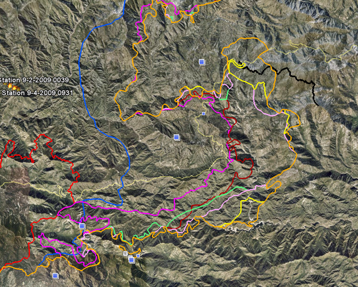
I downloaded fire perimeters for Aug. 30 - Sept. 6 (early morning) from http://www.geomac.gov/. The different colors are different days -- orange is obviously today. The short black line is a GPS trace of a hike form Three Points to Twin Peaks.
-
Jim

- Posts: 23
- Joined: Fri Oct 05, 2007 11:28 pm
I found this on the Waterman web site.
Mountain News September 6th, 2009
Over 250 Firefighters are stationed at the Angeles Crest Christian Camp. They have spent the last few days trying to save Newcombs Ranch, Chilao and the Mt Waterman Areas. We did lose some structures in the Chilao area, but at this time they are keeping the fire in devils canyon.
Take a look at the image below, that is a cam shot from Mt Wilson and it shows the fire down in the canyon on the back side of Mt Waterman. Fire crew expect the fire to remain in this area. However keep the prayers coming as we are not of out danger yet!
Also to note: The Angeles Crest Hwy is now closed from La Canada to Islip Saddle. No date has been set to reopen the road. Much work will need to be done before most of us will be able to enjoy Mt Waterman again. We will keep you updated here, on our face book page and at our Snow Phone 818-790-2002.
http://www.mtwaterman.org/
-
Leighton

- Posts: 9
- Joined: Fri Feb 27, 2009 3:07 pm
Typical conspiracy theorist nonsense, if you ask me.kgw wrote:What do youse guys think about what this fellow has to say?
-
Layne Cantrell
- Posts: 127
- Joined: Tue Sep 01, 2009 5:20 pm
Well on the plus side I emailed District Ranger Mike McIntyre and he said they were able to put out the spot fire over highway 2. Hopefully at least some of the area will be saved.cougarmagic wrote:Wrong. Sorry.
Thanks for the map and the sentiment. We're all hurtin' now but at least this place gives us a somewhere to vent where people don't think we're crazy.
-
Jim
- Posts: 23
- Joined: Fri Oct 05, 2007 11:28 pm
They are about a mile and a half past Newcombs to the east on ACH.
UPDATE ON THE
STATION FIRE
As of Saturday, September 5, at 7:00 a.m. Angeles Crest Christian Camp is still safe and protected! The firefighters are continuing to hold the line against the fire.
Last night at 8:00 p.m., we received word from Pat Titus, Batallion Chief for the L.A. County Fire Department that everything was still safe up at the camp. They are continuing to work in the area around Chilao campground and to hold back the flames that flared up again from Devil's Canyon. Newcomb's Restaurant is still safe as is Camp Eaton and Angeles Crest Christian Camp.
Firefighters are still working out of Angeles Crest Christian Camp to create firebreaks and keep the fire from spreading. Other good news was that they were able to use aircraft yesterday to help supress the fire lines. This is the first time the weather has allowed the Fire Department to bring in air drops of fire retardant. Chief Titus shared that it will still be a few days before things are under control.
Web site: http://www.angelescrest.com/
-
cougarmagic
- Posts: 1412
- Joined: Wed May 07, 2008 5:21 pm
-
Layne Cantrell
- Posts: 127
- Joined: Tue Sep 01, 2009 5:20 pm
You'n me both, man.
-
Layne Cantrell
- Posts: 127
- Joined: Tue Sep 01, 2009 5:20 pm
Update:
At least it ain't burning unattended.As of Sunday, September 6, at 12:00 noon Angeles Crest Christian Camp is still safe from the fire!
The latest update is that Angeles Crest Christian Camp is still safe from the advancing fires. We received word yesterday that many of the firefighters were taken off the mountain because of advancing flames. The only ones still there were some special emergency firefighters. This was cause for concern as we were not sure what happened with our main campus.
Today we got word from a source up on the mountain that the main campus of Angeles Crest Christian Camp was untouched but that the fire is still close to our camp. They are sending the firefighters back up to the site again to continue to fight back the fire that in some places has jumped highway 2and is now near the camp.
-
Bill

- Posts: 332
- Joined: Thu Jul 24, 2008 6:09 pm
Not sure exactly, but I know most of these applications are great under ideal circumstances,(flat ground with no wind) but do not perform well under the extreme conditions present in our local mountains. (steep terrain, high elevation, heavy smoke) And if this air frame is similar to other eastern European designs, do we really want this flying Yugo or whatever it is over populated areas. Let alone the danger to the pilot!kgw wrote:What do youse guys think about what this fellow has to say?
-
Jim
- Posts: 23
- Joined: Fri Oct 05, 2007 11:28 pm
Bill said: "flying Yugo" 
You're killing me partner!!!!
It may have worked on the San Diego fire where it probably would have mowed down whole blocks of houses with tons of water before they could burn.
But flyin' Yugo----that's a good one----I'm dyin'
You're killing me partner!!!!
It may have worked on the San Diego fire where it probably would have mowed down whole blocks of houses with tons of water before they could burn.
But flyin' Yugo----that's a good one----I'm dyin'
-
kgw
- Posts: 133
- Joined: Fri Jul 18, 2008 11:48 am
Just because you're paranoid doesn't mean they aren't out to get you...

-
Ze Hiker

- Posts: 1432
- Joined: Mon Jul 28, 2008 7:14 pm
that plane couldn't possibly work. Illusion is spelled wrong 
-
HikeUp
- Posts: 4082
- Joined: Thu Sep 27, 2007 9:21 pm
Wow!

Flying Yugo has to be one of the funniest things I've heard...ever!
Flying Yugo has to be one of the funniest things I've heard...ever!