
I'm done after offering an alternative view to his. Sorry for the temporary hijack.AlanK wrote:Let's keep politics out of this. I do not blame Kit Fox for his long political post because he die not start it, but DamOTclese has, in effect, offered a truce. Or at least a cease fire.
The Station Fire Thread
-
Kit Fox

- Posts: 152
- Joined: Tue Dec 25, 2007 11:33 am
-
edenooch

- Posts: 504
- Joined: Fri Jul 03, 2009 7:42 pm
so when im hiknig thru switzers or colb canyon in 2 months its gonna look like this?
-
Mike P

- Posts: 1005
- Joined: Tue Oct 02, 2007 10:48 pm
Kit Fox- My sentiments exactly!Kit Fox wrote:It happened because most of the area hasn't burned since the 50s. I'm going to catch some heat, but, the proper thing to do is protect the structures, and let nature take its course. Fire is natural, but the tree hugger motto of protecting the forest by never allowing it to burn is both unnatural, and unhealthy for the forest. The same thing happened during the La Brea fire. Old growth was allowed to burn itself out.mattmaxon wrote:There needs to be an investigation as to why this happened, they need to hold the people responsible accountableI'd rather see the forest burn more often, stopping for 50 plus years only makes it worse.It could also be USFS policy to let things burn when they're not threatening residential houses. I would rather see houses burn than the forest.
Believe me, I am extremely bummed about the forest destruction, watershed damage, and animal loss. The armchair quarterbacking here is quite entertaining. (OK, now I am off some of your Christmas card lists
-
Ze Hiker

- Posts: 1432
- Joined: Mon Jul 28, 2008 7:14 pm
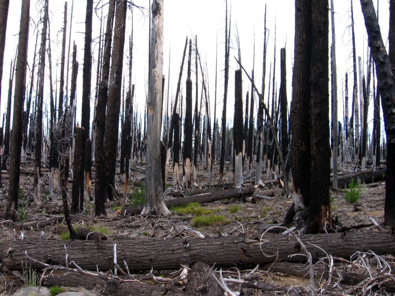
I hate to see our beloved forest burn, but at the same time it is a natural occurrence. Hard to accept
-
Tim

- Posts: 560
- Joined: Tue Apr 08, 2008 8:55 pm
This part of it boggles my mind:
Five people who refused to evacuate threatened areas reported they were trapped at a ranch near Gold Creek, Los Angeles County sheriff's spokesman Steve Whitmore said. A sheriff's helicopter was unable to immediately reach them because of intense fire activity, Whitmore said, but would try after the flames passed.
"What this says is, 'Listen, listen, listen,'" Whitmore said. "Those people were told to get out two days ago, and now we are putting our people in danger to get them out."
Over the weekend, three people who refused to evacuate were burned when they were overrun by flames, including a couple who had sought refuge in a hot tub, authorities said.
-
AlanK

- Posts: 1069
- Joined: Thu Sep 27, 2007 9:28 pm
From the Pasadena Star News.
It is interesting that there may have been a fire about this size about 120 years ago, way before man was trying very hard to put them out. This is not to argue one way or another about whether or not to fight forest fires. But ths idea that large fires are the creation of modern humans is an oversimplification.Station Fire biggest in county history since 1897
By Dan Abendschein
Posted: 08/31/2009 02:22:18 PM PDT
At 105,000 acres, the Station Fire now appears to be the biggest fire in Los Angeles County's history since 1897, according to a county fire department historian.
Dave Boucher, a retired firefighter who serves as the historian for the fire department and a local fire history museum, said the 1897 fire burned down huge swaths of the Angeles National Forest.
"In 1897 it burned over the whole forest," said Boucher. He said he was not sure how big the acreage of the 1897 fire, and the Station Fire could actually be bigger.
Other notable fires have included the 1970 Clampitt fire, which also burned about 105,000 acres, from Agoura Hills to Newhall. That fire was actually two separate fires that converged, said Boucher, rather than a single fire.
The Station Fire also ranks among the top 20 in size in state history, according to state government records, around 15th in size. It could still get a lot bigger, said Boucher.
"By the end it could be 125,000 to 150,000 acres," said Boucher.
At 150,000, it would move in to the top 10 in state history.
Bigger local fires of note in the last few years have included the Witch fire in October of 2007 in San Diego County, which consumed 197,990 acres. The biggest recorded in state history, according to state records, is the Cedar fire in San Diego County, which burned 273,246 acres in October of 2003.
-
Rick Kent

- Posts: 150
- Joined: Tue Oct 02, 2007 11:21 am
Ok, so what's the latest? Has the fire reached Twin Peaks yet? I see from Matt's last update what looks like fire on the east side of hwy2 just east of Charlton Flats. I think I read they were trying to hold it off around there and had to pull out.
-
edenooch
- Posts: 504
- Joined: Fri Jul 03, 2009 7:42 pm
why does the news just show the fire in the same area only.. we wanna see the whole forest and firezone! i dont wanna see any more burn charts or plots on topos........ 
-
He219

- Posts: 386
- Joined: Thu Sep 27, 2007 11:18 pm
One of my buddies is planning on going on Echo right now.
I advised him against it; air quality and visibility probably suck and he could find himself in a world of hurt if the wind picks up or shift.
Maybe you'll get some interesting pix, edenooch

I advised him against it; air quality and visibility probably suck and he could find himself in a world of hurt if the wind picks up or shift.
Maybe you'll get some interesting pix, edenooch
-
edenooch
- Posts: 504
- Joined: Fri Jul 03, 2009 7:42 pm
my buddy just emailed me and said that the mt lowe fire road ion FIRE!!
is the old taver ncampsite up there scorched too?
I remember seeing a cabin near a connecting trail rom dawn mine to that road....i hope hats not history!
is the old taver ncampsite up there scorched too?
I remember seeing a cabin near a connecting trail rom dawn mine to that road....i hope hats not history!
-
Rumpled
- Posts: 271
- Joined: Mon Feb 25, 2008 10:57 pm
It's amazing to me that this fire has seemed to go up, down and over mountains and drainages without a wind event.
Notice that most of these larger fires have all been in recent years, the accumulation of not letting anything burn.
Though, we can't ever seem to get controlled burns right, as there is one out of control in Yosemite right now.
Notice that most of these larger fires have all been in recent years, the accumulation of not letting anything burn.
Though, we can't ever seem to get controlled burns right, as there is one out of control in Yosemite right now.
-
edenooch
- Posts: 504
- Joined: Fri Jul 03, 2009 7:42 pm
news said those cnyon aint burned in 30 years...after this looks like were good for anoter 30
-
Mike P
- Posts: 1005
- Joined: Tue Oct 02, 2007 10:48 pm
Alan, you made me look into John Robinson's book, The San Gabriels, where he quotes Rush Charlton (early San Gabriel Reserve supervisor) regarding two Sept. 1919 fires that joined:AlanK wrote:From the Pasadena Star News.It is interesting that there may have been a fire about this size about 120 years ago, way before man was trying very hard to put them out. This is not to argue one way or another about whether or not to fight forest fires. But ths idea that large fires are the creation of modern humans is an oversimplification.Station Fire biggest in county history since 1897
By Dan Abendschein
Posted: 08/31/2009 02:22:18 PM PDT
At 105,000 acres, the Station Fire now appears to be the biggest fire in Los Angeles County's history since 1897, according to a county fire department historian.
Dave Boucher, a retired firefighter who serves as the historian for the fire department and a local fire history museum, said the 1897 fire burned down huge swaths of the Angeles National Forest.
"In 1897 it burned over the whole forest," said Boucher. He said he was not sure how big the acreage of the 1897 fire, and the Station Fire could actually be bigger.
Other notable fires have included the 1970 Clampitt fire, which also burned about 105,000 acres, from Agoura Hills to Newhall. That fire was actually two separate fires that converged, said Boucher, rather than a single fire.
The Station Fire also ranks among the top 20 in size in state history, according to state government records, around 15th in size. It could still get a lot bigger, said Boucher.
"By the end it could be 125,000 to 150,000 acres," said Boucher.
At 150,000, it would move in to the top 10 in state history.
Bigger local fires of note in the last few years have included the Witch fire in October of 2007 in San Diego County, which consumed 197,990 acres. The biggest recorded in state history, according to state records, is the Cedar fire in San Diego County, which burned 273,246 acres in October of 2003.
"The greatest fire we have ever known in southern California has destroyed the Pacoima watershed and caused tremendous damage to the Tujunga, San Gabriel, and San Dimas watersheds...." Now that is an impressive fire! Apparently, one fire started in the Narrows of the East Fork while another started in the Big Tujunga.
-
edenooch
- Posts: 504
- Joined: Fri Jul 03, 2009 7:42 pm
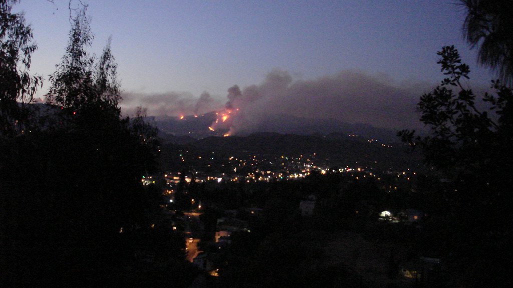
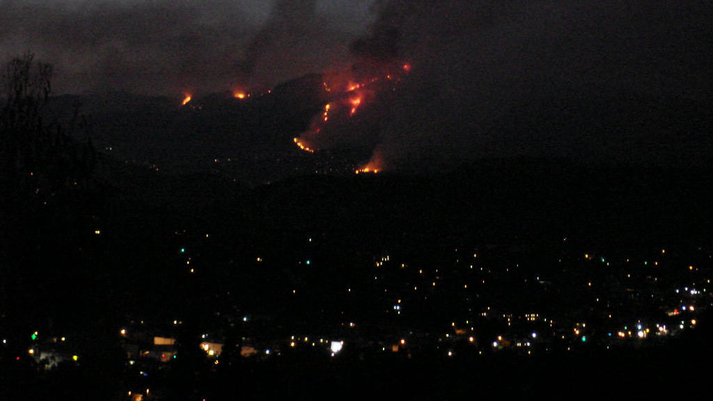
The latest views from mt washington stairs
 The Dark mountain range below the fire is eagle rock ridge
-
HikeUp

- Posts: 4067
- Joined: Thu Sep 27, 2007 9:21 pm
I kind of view these fires as sort of a natural event 'enhanced' by man. It's natural, but it may or may not be of the natural magnitude. Either way, nature will recover as long as we don't do something stupid in response (like plant unnatural foliage to prevent erosion and mudslides, etc.).
Kind of like the Exxon Valdez oil spill. It's just oil, for pete's sake!!!
Kind of like the Exxon Valdez oil spill. It's just oil, for pete's sake!!!
-
HikeUp
- Posts: 4067
- Joined: Thu Sep 27, 2007 9:21 pm
I wonder if it would have been better off (in terms of the resulting size of the fire) if this had occurred during a wind event. The wind would have driven it in a single direction as opposed to the 360 degree spreading that has actually occurred. Yes it would have been 'worse' perhaps for the people/structures down wind but it certainly wouldn't have spread so omnidirectional...right?
-
edenooch
- Posts: 504
- Joined: Fri Jul 03, 2009 7:42 pm
DamOTclese wrote:Be glad your not in Tenessee where the fire flies will burn your house down!HikeUp wrote: How many fire-making plant or animal species are there in Earth's biosphere? I can count them on one hand.
I'm going to head South to get out of the smoke and get a Motel room for the evening.
-
Hikin_Jim

- Posts: 4688
- Joined: Thu Sep 27, 2007 9:04 pm
Tried to go up tonight to check on things. Mand. evac. area now multiple blocks lower. Couldn't get a look
Fire now burning right down to the houses in Tujunga. I'm about 4 blocks west and 1 block south of the evac. area. Don't feel particularly threatened, but if the wind kicks up ...
I keep hearing that we might get the tail of some tropical storm down south (Jimena?). A little rain would be good right now. A lot of rain would be a disaster.
-
Hikin_Jim
- Posts: 4688
- Joined: Thu Sep 27, 2007 9:04 pm
Aw, !!#$!&&&*.DamOTclese wrote: Mount Waterman is being threatened.
Hell, Crystal Lake could get hit again!
-
Hikin_Jim
- Posts: 4688
- Joined: Thu Sep 27, 2007 9:04 pm
I'll vote for that, particularly if it's a cease Station fire.AlanK wrote:Let's keep politics out of this. I do not blame Kit Fox for his long political post because he die not start it, but DamOTclese has, in effect, offered a truce. Or at least a cease fire.
-
Hikin_Jim
- Posts: 4688
- Joined: Thu Sep 27, 2007 9:04 pm
There was a chaparral expert on NPR this morning. Interestingly, he said that the rate of fires is about the same as historical patterns. Many fires are suppressed, but there are a lot more fires now that human beings are around. His opinion was that "controlled burns" although effective in pine forests are ineffective, even destructive in a chapparal environment.HikeUp wrote:I kind of view these fires as sort of a natural event 'enhanced' by man. It's natural, but it may or may not be of the natural magnitude. Either way, nature will recover as long as we don't do something stupid in response (like plant unnatural foliage to prevent erosion and mudslides, etc.).
Kind of like the Exxon Valdez oil spill. It's just oil, for pete's sake!!!
In a pine forest, the fire burns through quickly, cleaning up the forest floor but leaving the trees intact. In a chapparal area, everything is destroyed. His research indicates that burns every 50 - 150 years are what the chapparal plant community needs. In other words, there should be a good number of years between burns in order for a chapparal community to be healthy. He pointed out how a major fire swept through San Diego just four years after another brush fire had burned through the same area. He said that the idea that burning the chapparal every so often to keep fire danger down is a total myth and is not reflected in a study of historical data and chapparal plant community studies.
His remarks made a lot of sense to me.
-
mattmaxon

- Posts: 1137
- Joined: Mon Mar 24, 2008 12:48 pm
The Beast has continued it relentless crawl through our playground overnight
Mostly it has two flanks now, West and East
The west flank bordered by Little Tujunga Canyon
The East flank has two claws. The North One on Pacifico Mtn heading toward Pleasant View Ridge
The south claw roughly bordered on the south by the West fork and Mt Wilson Devils Cyn on the East and Upper Big Tujunga on the north
-
edenooch
- Posts: 504
- Joined: Fri Jul 03, 2009 7:42 pm
Todays issue of the Times has a 4 page article and a simplified map.....
nice article of the 2 firefighters as well......Go get it
nice article of the 2 firefighters as well......Go get it
-
solar

- Posts: 14
- Joined: Fri Aug 21, 2009 9:08 pm
At least the weather is slowing changing for the better.
Woke up to a marine layer.
Red Flag Warning cancelled, humidity near 20% at Mt Wilson this morning.
According to the NWS 20% chance of T-storms in the mountains today.
Matt- thanks for the maps! sweet
Woke up to a marine layer.
Red Flag Warning cancelled, humidity near 20% at Mt Wilson this morning.
According to the NWS 20% chance of T-storms in the mountains today.
Matt- thanks for the maps! sweet
-
simonov

- Posts: 1107
- Joined: Tue Nov 27, 2007 5:44 pm
- Location: Reno, NV
The LA Times has a pretty good Google Map they have been updating for almost a week. Includes all the fires, including Oak Glen:
http://maps.google.com/maps/ms?ie=UTF8& ... urce=embed
http://maps.google.com/maps/ms?ie=UTF8& ... urce=embed
Nunc est bibendum
-
outwhere

- Posts: 323
- Joined: Sun Jan 25, 2009 5:40 pm
A little bit ago, ktla showed some rather large flames and said they were to the east of Mt. Wilson.
Then they said something about a cafe that burned and all that was left was a phone booth... the shot they showed of the phone booth was not enough for me to figure out where it was...
Like with many of these new reports, it left me wondering, 'where/what exactly are they talking about'...
They only thing I could think of was Newcomb's - but that's just a big big guess on my part. Sure hope I'm wrong...
-
edenooch
- Posts: 504
- Joined: Fri Jul 03, 2009 7:42 pm
that must be hidden springs cafe. by the bridge/tunnel section of the forest hwy...............It was a little hole in the wall but its a shocker to know every thing from la canada to there is history
-
Rick Kent
- Posts: 150
- Joined: Tue Oct 02, 2007 11:21 am
Hey Matt, do you have a new KML file put together yet?