Little Fish Fork Overnighter, 7/2 - 7/3/2009

TRs for the San Gabriel Mountains.
User avatar
Hikin_Jim
Posts: 4686
Joined: Thu Sep 27, 2007 9:04 pm

Post by Hikin_Jim »

A couple of friends and I went down to Little Fish Fork on Thursday, 7/2/2009, after work for a quick overnighter. It's a really peaceful spot and worth checking out. The really good news (for me) is that my injured knee held up well.

Image

We felt like we were really "away from it all" while we were there although we did run into a couple of other "backpackers" (see note at end) the next day who had camped further down towards UFF and then one set of day hikers on our way out. Still, running into only two other groups on a Fourth of July weekend isn't bad.

More photos: http://picasaweb.google.com/jim.barbour ... slideshow/
Someone please check and see if I've identified Ross Mountain and Rattlesnake Peak correctly.

WATER
The creek at Little Fish Fork Camp, and the spring in the next drainage down were both flowing well.

NAVIGATION
The navigation is fairly straightforward even though the USGS topo shows quite a number of different trails scattered about and, if you switch to satellite photo mode, you can see that there are even more bits of trail than shown on the topo map.

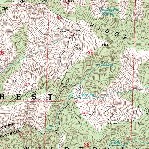
Basically, you park near the trailhead which is Point "A" on this topo map, just before you get to Lupine Campground. There's no lot; I just pulled off the dirt road. I was driving a Honda Accord and had no problems with driving the road down into Prairie Fork. From the trailhead, one follows the old road bed. There's good sized stream at point "B." A pipe leads from here down towards Lupine; I assume this is where the campground gets it's water. At point "C," you cut up to the trail going up Pine Mountain Ridge. Note that you do NOT have to proceed all the way to point "D" where the old road ran. The trail cuts up at point "C". There is a trail sign on top of the ridge at point "C." From "C," proceed up Pine Mountain Ridge following the old road bed to point "E" where an old road bed cuts off of Pine Mtn Ridge and heads for LFF. Look for a fallen sign here:
Image
From the point where the fallen sign is (point "E"), visually follow the most prominent road bed to a small saddle (point "F") on a an intervening ridge between the LFF drainage and Pine Mountain Ridge. The saddle:
Image
Just walk the old road bed until you get to the small saddle. The old road is pretty wiped out by a slide about mid-way to the saddle, but the slide can be traversed on foot without too much difficulty. Those nervous around slidey rocks on steep slopes may wish to hike elsewhere.

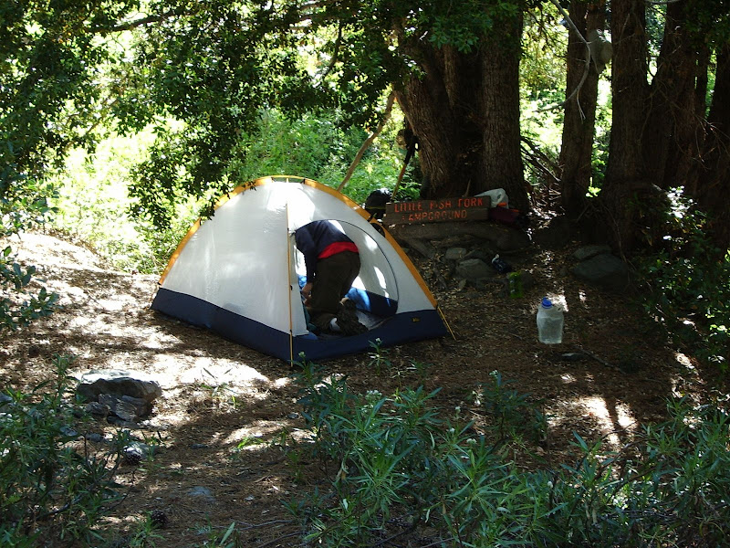
A trail leads south, down from the small saddle via a series of switchbacks until it joins an old road bed at approx point "G." Follow the old road bed as it first goes east, crosses the drainage, and then switchbacks down to LFF Camp ("H"). Note that the topo map shows that the switchback stops short of re-crossing the creek in the vicinity of point "H." The map is incorrect. The road bed does re-cross the creek, and LFF Camp is in a wide spot in the road on the lower switchback on the NW side of the creek. I've tried to show the location of the camp a little bit more precisely with the little red star on this topo:
Image

The trail is a bit rougher below LFF Camp, but still followable. You should notice a little bit of lopper work through this section where we trimmed back a bit of brush. The thing to bear in mind is that the trail follows the creek approximately equi-distant above the creek as it descends to UFF Camp as shown on the above map snippet. On the ACME map link, you want to proceed via point "K" in order to get to UFF Camp.

I didn't try to find or follow the Dawson Peak Trail (DPT) which is denoted by point "L" on the ACME link, although we did meet two backpackers who said that they had descended it part way, losing the trail at some point. We could see the DPT above us as we descended towards UFF. The two trails diverge in a dry wash immediately south of the wet creek at point "I." The dry wash is denoted by point "J." Note that even though Dawson Peak lies to the east, the DPT proceeds SW at this point roughly paralleling the trail to UFF although higher up. I think the topo map snippet inserted inline above shows the relationship between the trail to UFF and the DPT best.

We were taking our time and didn't even leave LFF until after noon to go to UFF. My friends wanted to be back in town Friday P.M. at a reasonable hour, so we stopped short of going all the way to UFF, much to my dismay. It was nice, however, to sleep in and just while away the hours Friday morning at LFF. Next time I'm out, I'll have to be a little bit more goal oriented and get all the way down to UFF!

I hadn't been back into this area in a number of years and was gratified to see that it's still as nice as I remember it!


END NOTES
We ran into a couple of "backpackers" who said that they had come down the Dawson Peak Trail but had lost the route to get into the Little Fish Fork area. I think they may be relatively new to backpacking. I saw no evidence of map, compass, or GPS. They seemed quite surprised to see us and even more surprised that we we had come in from Lupine (a much easier way in to the area).

They informed us that they had left behind some "supplies" in case we needed anything. I followed their trail to their camp "site" -- they hadn't found a site at all but had camped in a semi-level rocky dry spot in the creek bed. I found their supplies all right -- all 12.6 pounds :shock: worth. It was mostly food, but also trash, clothing, fuel, and batteries. Like I say, I think they were noobs. They had just carried way too much stuff and had jettisoned a bunch of gear in the back country (and when we saw them we commented amongst ourselves on how big and stuffed full their packs were AFTER they had jettisoned gear). We also noticed how their gear was clean and new. Like I say: noobs. Nothing against noobs, mind you, but don't jettison a load of gear in the backcountry. Grrr. :evil: Note: We packed out their crap. Some of the battieres were fully charged lithium AAA cells. Score!

However, these guys weren't the worst case. If you saw the link to the photos from Matt's recent TR, you'll see some trash. What Matt doesn't mention is that trash is a family type car camping tent. Below it, we found the remains of a double bed sized inflatable car-camping mattress -- the kind that have a pump and are two feet thick. We also found a two burner propane grill with regulator and propane tank as well as aluminum frame camp chairs. How the heck did these people get this stuff back in there? :lol: Noooobs! Now come back and haul your frickin' trash out!! :evil:

Note: We didn't haul out that old crap. Even I have my limits.
User avatar
HikeUp
Posts: 3861
Joined: Thu Sep 27, 2007 9:21 pm

Post by HikeUp »

Nice looking area. Always have been curious about that place so thanks for the pics and maps.

How'd those new loppers work out for you?
User avatar
Hikin_Jim
Posts: 4686
Joined: Thu Sep 27, 2007 9:04 pm

Post by Hikin_Jim »

HikeUp wrote:Nice looking area. Always have been curious about that place so thanks for the pics and maps.

How'd those new loppers work out for you?
Those loppers are GREAT. They are super light and cut really well.

How long have you had yours? I'm not sure how long they'll hold up to hard use since they're mostly made out of fiberglass/spun glass, but dang are they light. How has the edge on yours held up? Are they difficult to sharpen?
User avatar
Taco
Snownado survivor
Posts: 6011
Joined: Thu Sep 27, 2007 4:35 pm

Post by Taco »

It would be good to camp out on that trail where you overlook Baldy and San Antonio Ridge. Awesome view, especially in winter. I think I'll do that next season. Good area, Jim? Gonna use it as a basecamp of sorts for some random climbing bits.
User avatar
Desert Hiker
Posts: 5
Joined: Fri Sep 28, 2007 7:41 pm

Post by Desert Hiker »

Jim,
Did those loppers get you down to UFF? :?:
User avatar
lilbitmo
Posts: 1092
Joined: Tue Mar 04, 2008 9:44 pm

Post by lilbitmo »

Jim, thanks for all the information, maps, picrures and status of noobs leaving behind their stuff. Good to see your back out there.

Glad to hear your knee is doing well, mine did great in the White Mountains but I still keep a brace handy in case of emergency, nothing worse than not being able to hike myself out of the wilderness on my own two feet, or should I say "Hobble Out".

Glad to hear the Loper's are coming in handy as well.

:D
User avatar
Ze Hiker
Posts: 1432
Joined: Mon Jul 28, 2008 7:14 pm

Post by Ze Hiker »

nice TR! nice area.

would like to check out that trail and also go up the Dawson peak trail. hopefully no other trash in the area :?

loppers....what brand are these? maybe i should invest in a pair.

good to hear the knee is holding up....just make sure to increase the pounding gradually! 8)
User avatar
Hikin_Jim
Posts: 4686
Joined: Thu Sep 27, 2007 9:04 pm

Post by Hikin_Jim »

TacoDelRio wrote:It would be good to camp out on that trail where you overlook Baldy and San Antonio Ridge. Awesome view, especially in winter. I think I'll do that next season. Good area, Jim? Gonna use it as a basecamp of sorts for some random climbing bits.
There are definitely areas where one could camp on Pine Mtn Ridge. LFF or UFF would give you access to some North face of Baldy stuff that would be cool. East face of Dawson or Pine would be cool too.

I'm not a rock climber but I did note some interesting rock formations in the LFF/FF drainage.

Also, canyoneering would be pretty cool. The falls below UFF effectively cut off down stream travel to all but the technical canyoneer (or hardcore detour enthusiast!). Given that there are more falls downstream, the middle section of Fish Fork is remote indeed. Probably about as remote as it gets in the San Gabs.
Desert Hiker wrote:Jim,
Did those loppers get you down to UFF? :?:
Actually, my feet did most of the work, but the loppers did help out. :wink: Seriously though, you don't need loppers, but they are helpful. We also took a small hand saw which helped in some spots.
User avatar
Hikin_Jim
Posts: 4686
Joined: Thu Sep 27, 2007 9:04 pm

Post by Hikin_Jim »

wrote:nice TR! nice area.
Thanks. I rather liked it. Thanks to Bill and Matt for reminding me that it's there.
wrote:Would like to check out that trail and also go up the Dawson peak trail.
The classic loop would be:
A = Trailhead on Blue Ridge for north route to Baldy
B = Peak 8555 en route to Pine Mtn.
C = Small Saddle between Pk 8555 and Pine Mtn.
D = Pine Mtn
E = Pine - Dawson Saddle
F = Dawson Pk. (overachievers: proceed to Baldy and return)
G = Dawson - Baldy Saddle
H = Baldy (true overachievers: proceed to W Baldy and return)
I = Approx. location of Dawson Peak Trail (DPT) Jct. Hard to spot, but there is an old trail sign.
J = DPT descending down WSW ridge of Dawson
K = Traverse through a drainage of FF to the WSW ridge of Pine
L = DPT descending down WSW ridge of Pine
M = Little Fish Fork. Overachievers may wish to do a quick side trip to UFF from here.
N = Small Saddle above LFF. This is your exit point from LFF. Trail (not shown on Acme topo) passes through here
O = Jct atop Pine Mtn Ridge.
P = Jct with road coming up from Lupine Campground.
Q = Good water source above Lupine Campground.
R = Trailhead near Lupine Campground. Cheaters will park a car here and shuttle back to the trailhead on Blue Ridge
S = Road's End in Prairie Fork. Overachievers will walk to the end of the road and XC to return to the TH on Blue Ridge.
wrote:loppers....what brand are these? maybe i should invest in a pair.
These are Fiskars Anvil Loppers. $20.00 bucks at Sears. Pretty cheap. And freakishly light.
User avatar
Taco
Snownado survivor
Posts: 6011
Joined: Thu Sep 27, 2007 4:35 pm

Post by Taco »

Good deal, thanks Jim. SHould be good for photography too.
User avatar
HikeUp
Posts: 3861
Joined: Thu Sep 27, 2007 9:21 pm

Post by HikeUp »

Hikin_Jim wrote:How long have you had yours? I'm not sure how long they'll hold up to hard use since they're mostly made out of fiberglass/spun glass, but dang are they light. How has the edge on yours held up? Are they difficult to sharpen?
I've only used them twice for serious trimming and they show no signs of dulling or wear and tear. I've cut up to 1" thick stuff without them showing any stress or torquing. I think they are best suited for carrying on a hike just to clear some of the obvious annoyance type of brush (the occasional overhanging crap, etc.), not for anything hardcore like trail clearing/constructing.
User avatar
Hikin_Jim
Posts: 4686
Joined: Thu Sep 27, 2007 9:04 pm

Post by Hikin_Jim »

HikeUp wrote:I think they are best suited for carrying on a hike just to clear some of the obvious annoyance type of brush (the occasional overhanging crap, etc.), not for anything hardcore like trail clearing/constructing.
Makes sense. I've got some all metal, long-handled ones for real trail maintenance. Glad to have something so well suited to "out in the bush" use for getting through that dad-gummed ol' nasty brush.
User avatar
406
Posts: 321
Joined: Thu Jan 17, 2008 10:36 am

Post by 406 »

nice tr, I like the slide show.
enough water in the creek to take a dip?
User avatar
Hikin_Jim
Posts: 4686
Joined: Thu Sep 27, 2007 9:04 pm

Post by Hikin_Jim »

406 wrote:nice tr, I like the slide show.
enough water in the creek to take a dip?
Not at Little Fish Fork. I don't recall any rock pools or anything like that anywhere in the vicinity. Easy to filter or scoop, but not swimming depth.
User avatar
Hikin_Jim
Posts: 4686
Joined: Thu Sep 27, 2007 9:04 pm

Post by Hikin_Jim »

For those of you interested in the Fiskars Anvil Loppers, they're $20.00 at Sears.

Image
Photo credit: HikeUp
User avatar
Mike P
Posts: 1005
Joined: Tue Oct 02, 2007 10:48 pm

Post by Mike P »

OK. I'm sold! Gotta' get me one o' them loppers! I took a long-handle pair up Alder Creek trail. Got the reach, but what a PITA.

Nice pics, Jim!
User avatar
mattmaxon
Posts: 1137
Joined: Mon Mar 24, 2008 12:48 pm

Post by mattmaxon »

Hikin_Jim wrote:
HikeUp wrote:I think they are best suited for carrying on a hike just to clear some of the obvious annoyance type of brush (the occasional overhanging crap, etc.), not for anything hardcore like trail clearing/constructing.
Makes sense. I've got some all metal, long-handled ones for real trail maintenance. Glad to have something so well suited to "out in the bush" use for getting through that dad-gummed ol' nasty brush.
I've used these Fiskars loppers for about 5 years now... They are great! I have broken on pair though :( But to be fair I'd gotten carried away and should have used some heavy duty loppers

It's like you all have said they're great for a little trimming here and there, I have the "Big guns" too The Bypass type fiskars while heavier they will cut thick branches all day long with minimal effort

I have on friend who shorten the handles to make then easier to pack in and use in close quarters

They also make a collapsing pruning saw which I favor greatly over any saw I've ever had, and that is plenty of folding saws I can assure you (dozens)

I've been known to use the "nuclear option" from time to time, I favor the Echo CS-341 , it light weight, powerful and sips the gas!

RE: the trash heap
I was concerned it was from a MJ grow operation, thankfully there was no other signs.

They did expend a great effort to haul the crap in there, zero effort to haul it back out
User avatar
norma r
Posts: 707
Joined: Thu Nov 06, 2008 4:22 pm

Post by norma r »

jim,
nice backpack and TR. you are always so thorough, thanks for your beta and descriptions. makes me want to check this place out also.

i'm glad your knee is better. it's nice to see your smiling face in the wilderness and not just on your avatar!
:D
User avatar
Hikin_Jim
Posts: 4686
Joined: Thu Sep 27, 2007 9:04 pm

Post by Hikin_Jim »

Mike P wrote:OK. I'm sold! Gotta' get me one o' them loppers!
:lol: I think HikeUp and I deserve a commission from Sears. :wink:
User avatar
Hikin_Jim
Posts: 4686
Joined: Thu Sep 27, 2007 9:04 pm

Post by Hikin_Jim »

norma r wrote:jim,
nice backpack and TR. you are always so thorough, thanks for your beta and descriptions. makes me want to check this place out also.
Thanks, Norma. I've been called the "details guy" on other local boards. :) I saw on your recent Siete, Cinco, Seis, Olé! TR that you want to do Pine from the other side. Take a look at the route plan below. This is a long but interesting loop that I did some years ago with my dad that will not only get you to Pine from the "other side" but also get you down into the LFF area.
norma r wrote:i'm glad your knee is better. it's nice to see your smiling face in the wilderness and not just on your avatar!
And oh the face does smile when I'm out in the back country. :D :D :D

HJ

The Blue Ridge - Pine - Dawson - LFF - Lupine - Blue Ridge loop (with optional side trips to Baldy, West Baldy, and UFF) is as follows:
A = Trailhead on Blue Ridge for north route to Baldy
B = Peak 8555 en route to Pine Mtn.
C = Small Saddle between Pk 8555 and Pine Mtn.
D = Pine Mtn
E = Pine - Dawson Saddle
F = Dawson Pk. (overachievers: proceed to Baldy and return)
G = Dawson - Baldy Saddle
H = Baldy (true overachievers: proceed to W Baldy and return)
I = Approx. location of Dawson Peak Trail (DPT) Jct. Hard to spot, but there is an old trail sign.
J = DPT descending down WSW ridge of Dawson
K = Traverse through a drainage of FF to the WSW ridge of Pine
L = DPT descending down WSW ridge of Pine
M = Little Fish Fork. Overachievers may wish to do a quick side trip to UFF from here.
N = Small Saddle above LFF. This is your exit point from LFF. Trail (not shown on Acme topo) passes through here
O = Jct atop Pine Mtn Ridge.
P = Jct with road coming up from Lupine Campground.
Q = Good water source above Lupine Campground.
R = Trailhead near Lupine Campground. Cheaters will park a car here and shuttle back to the trailhead on Blue Ridge
S = Road's End in Prairie Fork. Overachievers will walk to the end of the road and XC to return to the TH on Blue Ridge.
User avatar
HikeUp
Posts: 3861
Joined: Thu Sep 27, 2007 9:21 pm

Post by HikeUp »

HJ,

Did you notice whether the road to the North Devil's Backbone Trail (point A on your latest ACMEFU map) open past Guffy?

FISKAR called and said the check was in the mail :wink:
User avatar
Hikin_Jim
Posts: 4686
Joined: Thu Sep 27, 2007 9:04 pm

Post by Hikin_Jim »

HikeUp wrote:Did you notice whether the road to the North Devil's Backbone Trail (point A on your latest ACMEFU map) open past Guffy?
Yes, it was open.
HikeUp wrote:FISKAR called and said the check was in the mail :wink:
Lol. I'm finally making a living at hiking. I love it. :wink:
User avatar
norma r
Posts: 707
Joined: Thu Nov 06, 2008 4:22 pm

Post by norma r »

Hikin_Jim wrote: Q = Good water source above Lupine Campground
R = Trailhead near Lupine Campground. Cheaters will park a car here and shuttle back to the trailhead on Blue Ridge
am i cheating if i wear a backpack and plan to camp here and shuttle back the next day? :wink:
User avatar
Hikin_Jim
Posts: 4686
Joined: Thu Sep 27, 2007 9:04 pm

Post by Hikin_Jim »

norma r wrote:
Hikin_Jim wrote: Q = Good water source above Lupine Campground
R = Trailhead near Lupine Campground. Cheaters will park a car here and shuttle back to the trailhead on Blue Ridge
am i cheating if i wear a backpack and plan to camp here and shuttle back the next day? :wink:
lol. I suppose we could cut you some slack. Or perhaps you'll have to add in Harwood just to make it right? :wink:

In looking at the Tom Harrison map, I think it would be about 11 miles to do the basic loop (Blue Ridge - Pine - Dawson - LFF - Lupine). Add in roughly another 3 miles (with some XC) to link up the two trail heads if a car shuttle isn't used. Add in another 2 miles for a side trip to UFF. Add in another 3 miles for a side trip to Baldy.
User avatar
Tim
Posts: 560
Joined: Tue Apr 08, 2008 8:55 pm

Post by Tim »

When HikeUp and I went down Cedar Canyon and into the depths of buckthorn hell, we talked about these loppers and how great they would be if just either one of us had remembered to bring them! They would have been handy to prune back some of the buckthorn that was too difficult to barrel through.

I eventually got these smaller Fiskar pruners at Walmart for about $10. I haven't used them on a trail yet, but they're pretty cool because the pivot is behind your hand. They're very compact and weigh just 4 oz, but they're probably only good for light duty pruning on green, living growth. I figured this isn't really for trail maintenance but more for just getting through a jam. So I'd probably just use it on yucca or buckthorn. It might turn out they are too light duty, dunno.

Image
User avatar
Desert Hiker
Posts: 5
Joined: Fri Sep 28, 2007 7:41 pm

Post by Desert Hiker »

Jim,
By any chance did you get some pics of the elusive UFF camp?
I did not see any in your photo log. :?:
Thanks
DH
User avatar
mattmaxon
Posts: 1137
Joined: Mon Mar 24, 2008 12:48 pm

Post by mattmaxon »

User avatar
Desert Hiker
Posts: 5
Joined: Fri Sep 28, 2007 7:41 pm

Post by Desert Hiker »

Awesome pics Matt and congrats on making it down to UFFC!
DH
User avatar
Hikin_Jim
Posts: 4686
Joined: Thu Sep 27, 2007 9:04 pm

Post by Hikin_Jim »

Desert Hiker wrote:Jim,
By any chance did you get some pics of the elusive UFF camp?
I did not see any in your photo log. :?:
Thanks
DH
No UFF photos. Sorry.
User avatar
Bill
Posts: 332
Joined: Thu Jul 24, 2008 6:09 pm

Post by Bill »

Dude! Awsome TR. I will archive for future trips! 8)
Post Reply