TacoDelRio wrote:Matt,
The link you posted requires membership on that site.
Oooooops...
TR: Silver on the side 2009_02_22 VIA Horseshoe Trail
* ACA Rating: 3B IV
* Our hiking time: 8hrs (est)
* Our Hiking distance: 6½ miles (est)
* Elevation loss: 1670 feet (est)
* Elevation gain: 1670 feet (est)
* Required equipment: Standard canyoneering gear 2, 200ft ropes, 100ft webbing 12 quicklinks
* Rappels: 9 (largest 180ft)
* Hazards: vehicle burglaries*, pot farmers, heat, loose/falling rock
* USGS TOPO map(s) Condor Peak, CA
General description:
After looking at SOtS from Big-T for sometime it was decided to attempt it from the Big-T side up the Horseshoe Trail to Suicide Cyn. Peeling off a short ways out of the campsite
Bernd and I had explored this the week before and concluded it was in fact possible, having hiked and cut our way through some of the brush
Emails assembled 4 canyoneers and the date was set!
(Note: all coordinates are WGS84 datum)
Trailhead*:
Stonyvale Picnic
The Trip:
This trip follows the route that was opened to Suicide Cyn I call Horse Shoe Trail, we proceeded up Big-T from Stonyvale Picnic crossing the river 3 times, bear rt at a faint use trail 0.58 miles from Stonyvale, past a 4” pipe / post painted brown to a use trail that goes up to an Oak shaded bench.
This is the Horse Shoe Trail. It wastes no time ascending steeply through the brush. @ About 1 mile you come to a small landing pad for a helo and a set of power poles. This is a good spot to catch your breath, enjoy the view and check out the first rap in Suicide Cyn
Above here you cross a narrow ridge and ascend a couple very steep spots, where handlines have been installed to aid pack laden canyoneers to get up. Thankfully the trail becomes less intense but still a 15% grade, until it starts to level, and then gradually descends a bit, until you come to an old campsite used by long gone pot farmers.
Here the trail makes a sharp left starting a gradual ascent, with plenty of Poison Oak to keep you on your toes, the trail starts turning to the west. At 2830ft (34.27404,-118.22343 ) there is a gradual right turn to the northwest, this is where we turn off Horse Shoe Trail, following the old Edison Trail
This should be easy to follow until it makes a sharp turn right toward the talus covered slope @ 3018 ft (34.27315,-118.22475) This is about 0.4 miles from where we left the Horse Shoe Trail. We stayed in the gully under the trees which becomes steeper with every step.
The loppers where soon unpacked as we proceeded up the ever narrowing gully until the ridge was in sight, we turned left at an outcrop making the final push (3277ft), reaching the ridge line at 3311ft (34.27174,-118.22565) An area was quickly cleared and we donned our gear, an anchor was set waist high in a bomber scrub oak and the first canyoneer went over with the loppers in hand.
This drop in was about 60-100ft (34.27162,-118.22558,3265) putting you a short way from the first big rappel in Silver On the Side, the 4th mentioned in Chris Brennen's beta (34.27159,-118.22438,3168)
We followed Chris Brennen's existing beta from here.
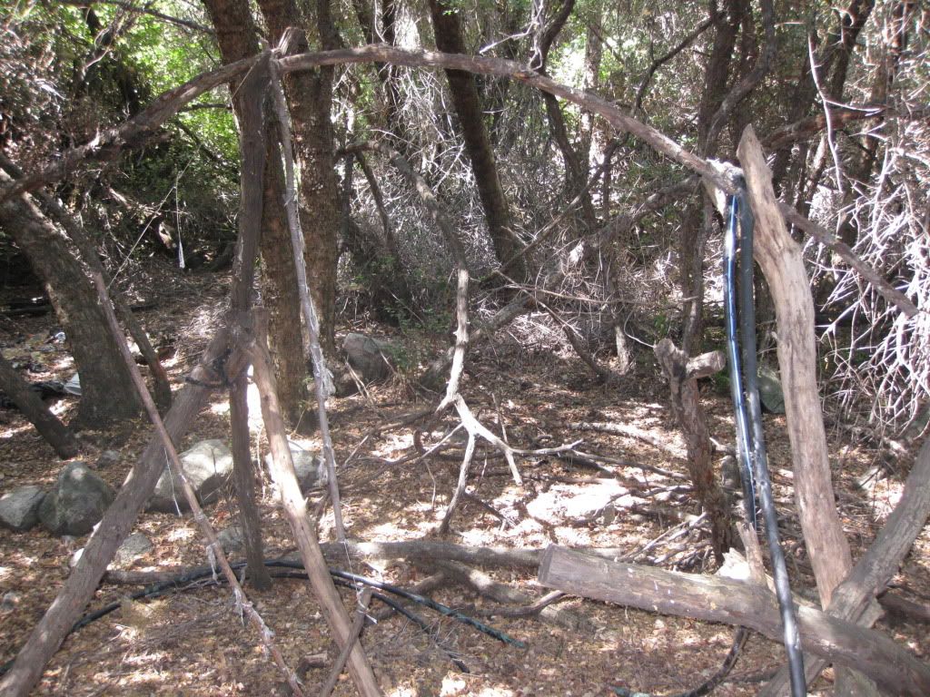
We stopped at the pot farmers campsite for lunch, now long abandoned though most of the piping, jugs, fertilizer bags, rat poison and just plain trash was still here. What an eyesore / mini toxic waste dump
I have wanted to work with the Forest Service or Sheriff's Department to setup a dedicated group who would come into these sites and package this stuff for removal by helicopter. The prospect of hauling all this out on my back is daunting. There are many such sites in the local mountains, this is another in a long list of crimes perpetrated by these individuals
Matt
*Due to repeated auto burglaries at all Big-T trailheads it is highly recommended you not leave anything in your vehicle, not in the trunk or anywhere else, leave the windows down too...Oh the joys of urban canyoneering!