Anniversary & Birthday Hikes at Lupine

TRs for the San Gabriel Mountains.
Post Reply
User avatar
Sean
Cucamonga
Posts: 3772
Joined: Wed Jul 27, 2011 12:32 pm

Post by Sean »

We belatedly celebrated the forum's anniversary, and simultaneously had a birthday weekend for Jeff, by spending Saturday and Sunday at beautiful Lupine Campground. Between drinking tequila and eating cake, some hiking was also accomplished, one trip to Cabin Flat and Native Son Mine, and another to Pine Mountain Ridge. Oh, and it rained during the freezing cold night.

I had heard that the road to Lupine was open and in decent shape, but I called the Forest Service on Friday to see if this was still the case. The lady who answered told me it was closed due to bad conditions. Trusting this information, I immediately informed John and Jeff that we'd have to hike in from Guffy Campground. But John, who went up a day early, replied that the gate was open and he already had claimed a camping spot for us. This was a relief, but now I have zero confidence in what the Acton Work Station tells me.

Saturday morning I picked up Jeff in Claremont and we were on our way by 7am. After a stop in Wrightwood for last-minute items, we took the dirt road to Lupine. This was Jeff's first time on the Blue Ridge Road and we stopped for a couple photos of the views.

The descent into Prairie Fork had two interesting sections, a spring crossing with large puddles and the Prairie Fork crossing itself, which was dry but very rocky. My Honda Pilot made it with no issues. I'd caution against taking a sedan down this road, but we actually saw people in a sedan at Lupine, so it's possible. I still don't recommend it.

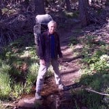
We met John at the campground. He had picked out the best spots away from the toilets. After hanging out a bit, we put our packs together and started hiking down the road to Cabin Flat.

DSC08980.JPG

DSC09036.JPG


There were hunters around, but we didn't see anyone en route to Cabin Flat. Below Lupine the road deteriorates, with rough bypasses for downed trees. The tire tracks ended fairly quickly, as trees and brush narrowed the path in some sections. I attacked a few overhanging branches with the machete, but really the trail is fine for hikers, pretty much a road the whole way.

It was a gorgeous day, and at one point we could hear the stream flowing again. The road made a u-turn and approached Cabin Flat, which used to be a large, developed campground. The outhouse is still standing.

DSC08985.JPG


And further down the road remains a picnic area with several tables.

DSC09006.JPG


Someone had left a suitcase here. We used it to pack out a bunch of garbage.

IMG_20221023_131106428.jpg


A path led down to the stream, which was flowing nicely.

DSC09001.JPG


I found an abandoned wildlife camera with corroded batteries, so I hauled it out. It died in 2020, having accumulated 15 gigabytes worth of pictures and videos--mostly of deer and squirrels, some humans, a couple shots of a bear's hindquarters, but nothing truly amazing.

IMAG0147.JPG


After our break at Cabin Flat, we went hunting for the Native Son Mine and found it. You have to crawl inside, but after fifteen feet or so you can stand upright. It goes back a few hundred feet at least. We stopped once the water level reached above our shoes.

Getting to the mine required more machete work and some easy scrambling up and down a steep slope.

DSC09032.JPG


We made it back to Lupine and celebrated Jeff's birthday with cake and tequila.

DSC09038-001.JPG


I guess I liked the Cazadores tequila because I got fairly plastered. Jeff made a Ramen bomb so I could eat something hot, and John helped me set up my tent before the expected rain began falling. I remember trying to say words during dinner, stumbling a lot, and then crawling into my tent. Then I passed out drunk.

To be continued...
IMG_20221022_135816617_BURST001.jpg
DSC09021.JPG
DSC09024.JPG
DSC09011.JPG
User avatar
Sean
Cucamonga
Posts: 3772
Joined: Wed Jul 27, 2011 12:32 pm

Post by Sean »

I woke up needing to pee in the middle of the night. Still a bit tipsy from the tequila, I recall being blasted in the face with wind-driven rain, doing my business, I guess, and then returning to my sleeping bag. But I failed to get inside the bag, because I later regained consciousness and found myself using it as a blanket rather than a bag. My feets were wet and cold, and they stayed wet and cold the rest of the night. I was now basically done sleeping, with several more hours of freezing darkness to endure. Thankfully the storm had passed.

At the very first light I arose and started moving around to get warm. I watched three hunters head up the Fish Fork Trail by headlamp. I dug a hole and filled it relatively easily, considering the temperature was in the low 30s. John was up by the time I returned to the car with my shovel. Then Jeff got up and we had breakfast.

The freezing weather slowly became nearly freezing, and we could finally remove a layer or two of clothing. Instead of waiting for the sun to pop over Pine Mountain Ridge, we decided to hike up the trail to the sunshine.

IMG_20221023_092331919_HDR.jpg

IMG_20221023_094511202_HDR.jpg

IMG_20221023_104420955.jpg


At the ridgetop we found a spot to sit out of the wind. We snacked and watched puffy, white clouds creep up the East Fork of San Gabriel Canyon, encircling Rattlesnake Peak.

IMG_20221023_115005465.jpg


We signed the register.

IMG_20221023_120322287_HDR.jpg


And took a selfie.

IMG_20221023_120906322.jpg


We returned to camp, drank a little, and ate stuffed olives.

IMG_20221023_131728551_HDR.jpg


Then we drove to Wrightwood for cheeseburgers at the Yodeler. Another successful forum hike. Good times.
User avatar
dima
Posts: 1340
Joined: Wed Feb 12, 2014 1:35 am

Post by dima »

Thanks for the report! I wanted to join this one, but was doing other stuff. Next time
User avatar
jfr
Posts: 153
Joined: Sat Dec 12, 2009 3:01 pm

Post by jfr »

Thanks for the great write-up, Sean! I can't really add a lot to that, except that we had a fun time.

After our hike to Cabin Flat and the mine, the puffy clouds of the day became a solid, threatening mass. It got windy and much colder without the sun. It didn't stop us from eating cake and wishing Jeff a happy birthday. But eventually it got to the point where even the tequila couldn't keep us warm enough, so we headed to bed fairly early. Luckily we all had the right gear to stay warm in the night, but I have to admit that I was glad to see that Sean didn't die of exposure! :D Maybe the tequila helped? We'll never know.

My car said that it was 33 degrees Sunday morning, and it sure felt like it. There was frost everywhere, and all the droplets from the rain were frozen. But at least the gusty winds had died down overnight. After a hot breakfast, we packed up camp and had a fun (uphill and warming) hike to the ridge, which had great views. The weather after storms is almost always beautiful, and this was no exception. Pine Mountain Ridge seemed like a very central spot. We could see many familiar peaks: Pine and Dawson to Baldy on the left, plus the long ridge to Iron in front of us, and around to the right was Baden Powell.

I'm going to have to add another post with photos, but I always take too many. I'm still in the process of deciding which ones to post, so they may have to wait until tomorrow.

Caltopo Map of the hike: https://caltopo.com/m/KH0B1


It was also my first mine exploration. Yay! I can see why this is an addictive hobby, with curiosity and danger in equal proportions. Here's my GoPro video of the mine:

My hiking trip reports: https://hikingtales.com/
User avatar
jfr
Posts: 153
Joined: Sat Dec 12, 2009 3:01 pm

Post by jfr »

Here's one of three multi-photo posts
334 John, Jeff, and Sean in the Native Son Mine.JPG
333 Sean sliding into the Native Son Mine, feet-first.jpg
332 Sean with Dual Headlamps for mine exploration.jpg
323 Sean cut a path through thick buckthorn with his new machete to gain access to the mine.jpg
312 Hiking east from Cabin Flat on FSR 3N39 toward the mine.jpg
308 Bullets and Olives for lunch.jpg
307 Eating lunch at the old Cabin Flat Campground.jpg
267 Sean and Jeff walking west toward Cabin Flat on FSR 3N39.jpg
My hiking trip reports: https://hikingtales.com/
User avatar
jfr
Posts: 153
Joined: Sat Dec 12, 2009 3:01 pm

Post by jfr »

Here's two of three multi-photo posts
425 Baldy, the San Antonio Ridge, and Iron from the Pine Mountain Ridge Trail.jpg
415 Fall colors on some sycamore leaves.jpg
403 Looking down the Prairie Fork toward Mount Baden Powell from 3N08, the Fish Fork and Pine Mountain Ridge Trail.jpg
364 Aftermath of the party - it was a 33 degree dawn and just getting light.jpg
357 The wind picked up and the air was cold as we ate Jeff's birthday cake, plus tequila and beer.jpg
349 Heading back to Lupine Camp with a bagful of litter and red flags for the deer hunters.jpg
340 Tall pines that survived an old burn in the Prairie Fork on FSR 3N39.jpg
338 The last of the Summer blooms - purple asters.jpg
My hiking trip reports: https://hikingtales.com/
User avatar
jfr
Posts: 153
Joined: Sat Dec 12, 2009 3:01 pm

Post by jfr »

Here's three of three multi-photo posts
510 Cheeseburgers and Beer at the Yodeler in Wrightwood.jpg
488 Looking down into the Prairie Fork from FSR 3N39 as we headed for Blue Ridge Road in the cars.jpg
458 Seam writing the official Pine Mountain Ridge register entry.jpg
454 Rattlesnake Peak shrouded in puffy clouds.jpg
448 The high point of Pine Mountain Ridge had to be along here somewhere.jpg
440 Rattlesnake Peak, looking southwest down the Fish Fork from Pine Mountain Ridge.jpg
My hiking trip reports: https://hikingtales.com/
User avatar
JeffH
Posts: 1166
Joined: Sun Nov 28, 2010 7:09 am

Post by JeffH »

I can't add much to the stories, except maybe the others actually downplayed the wind on Saturday night while we were at camp. It blew pretty hard for a while, then would subside at ground level for a bit while still roaring up in the trees.
The view walking up to the high part of Pine Mountain Ridge will stay with me for a long time - new growth trees among the older pines, clouds moving around the top of Rattlesnake Peak - it's a reminder of why I do this stuff.
Thanks again to John and Sean, you guys helped to make it a great weekend.

Standing in the mine.
8301C70D-6DE0-4F75-AF27-D48112C67812.jpg

These numbers were written on the walls.
82CE96B6-D89D-41D7-998C-8627A5A65AE9.jpeg

Celebrate good times c'mon!
7A28666B-5E27-413F-83EA-368A6046DFEF.jpeg

Mine from the upper road.
93994880-6DA8-4E4C-8CB8-AA6A987667B5.jpeg

Anyone know what this sign originally marked? Looks like WEST P is remaining.
721FD096-B3DB-46DC-AE14-9AA3BA6E8E71.jpg

Obligatory shot of the clouds.
068FF504-6491-436B-ABA9-702F92B81DBD.jpeg
"Argue for your limitations and sure enough they're yours".
Donald Shimoda
User avatar
Slowest_Hiker
Posts: 252
Joined: Sun Jul 31, 2011 12:31 pm

Post by Slowest_Hiker »

OMG I took a photo of the WEST P sign when I was up there a few years ago.
Post Reply