
http://www.wlfalwaysremember.org/incide ... ident.html
Anyone been to or know anything about this?
Old helicopter crash site in Bichota Canyon

Hmmm. I was up there this weekend to check out the road that used to go down into the canyon from the Pigeon Ridge road, but I only got about a mile in before I reached a huge washout with 10-foot vertical loose dirt walls. I did find an old overturned vehicle full of bullet holes. It resembled a Jeep Wagoneer, but I couldn't find any identifying markings anywhere on it.

I just checked "Historic Aircraft Wrecks of LA county" by G Pat Macha. He doesn't mention this incident, although 2 years earlier in 1968, an Alouette III crashed in the same area. He lists the name of the pilot, which is different from the ones in your link, so I guess this isn't a mistake.SGBob wrote: ↑http://www.wlfalwaysremember.org/incide ... ident.html
Anyone been to or know anything about this?

Could you post relevant quotes from that report on this thread? The link isn't working for me. Thanks.oldcoot wrote: ↑NTSB report on the 1970 event:
https://www.ntsb.gov/_layouts/ntsb.avia ... 7656&key=0
oldcoot


That marker does seem to be generic. The description mentions a botched ridgetop helipad landing followed by a fall into the canyon.
I've been to the area around the marker and followed an old road cut up to the south ridgeline. The grade in that particular vicinity doesn't seem likely to produce an 800 foot fall. Anybody know of likely helipad spots on either ridgeline?
I've been to the area around the marker and followed an old road cut up to the south ridgeline. The grade in that particular vicinity doesn't seem likely to produce an 800 foot fall. Anybody know of likely helipad spots on either ridgeline?
Another reminder of the hazards of trying something that requires lots of skill while under the influence…ATP (Airline Transport Pilot) is the highest-level pilot certificate there is, and 3390 hours is amazing for a 24-year-old (when I "retired" from mostly recreational airplane flying at the end of 2011, I had 3735 hours…but that was over nearly 50 years)…that pilot had lots of skill and experience but still bought it at age 24…party hearty, but not just before doing something that requires all your skill and wits…suspect that applies to serious hiking as well as operating complex machinery…be safe out there...
oldcoot
oldcoot
If we assume the 800-foot figure is reasonably accurate, I would assume the LZ was somewhere along the saddle between Bichota Canyon and Devil Gulch. The Fork Fire burned right up the canyon almost to that ridge, so it would be a good LZ and logical location for a fire line. It's about 800 feet down into the canyon bottom from there.walker wrote: ↑That marker does seem to be generic. The description mentions a botched ridgetop helipad landing followed by a fall into the canyon.
I've been to the area around the marker and followed an old road cut up to the south ridgeline. The grade in that particular vicinity doesn't seem likely to produce an 800 foot fall. Anybody know of likely helipad spots on either ridgeline?
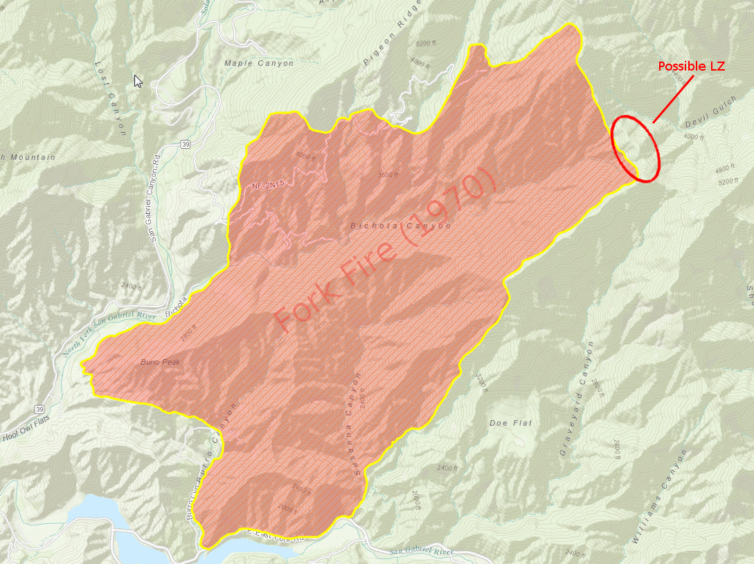
Although I suppose it could just as likely be the ridge line somewhere along that southeastern flank of the fire, but that saddle looks like a very strategic anchor point to me. If the fire crossed that saddle it has a straight shot all the way up the East Fork for a long ways.