We met at my house around 5:00pm on Monday July 16. The trip started out great with Paynes' Camaro blowing a carburetor as soon as he pulled onto my curb. We decided to take it on good faith that it hadn't blown in the middle of the freeway, and we were thankful to finally be leaving for our trip. We jumped in my car, went straight out to the local REI where we bought some dehydrated meals, some energy bars, a backpacking stove, and a boiling pot. By 6:30pm we had left the parking lot and were on the Freeway.
We arrived in Lone Pine around 11:30pm, we turned up the Whitney Portal road towards the Lone Pine Campground where we had a reserved site. We were greeted by a fantastic array of stars and the brilliant glow of the Milky Way We packed up our bags, set up our tents, and by 12:30 we were asleep. I awoke in the morning with gorgeous views, clean air, bright skies, and an enormous smile across my face, can I just say it felt so rejuvenating to be back in the Sierras. Although my goals had changed, for the first time in 16 years going to the Sierras I wasn't there to catch big trout, I was there to catch big peaks.
We quickly packed up our bags, and by 6:30 we were headed back down the road to Lone Pine to go and hopefully get Walk-In Permits. Since it was a Tuesday I figured we may have good odds. Sure enough by 8:30 we were out the door, permits in hand, packs in the truck, and our mountain nearby. Absolutely pumped is the best way to describe how I felt.
Heading back up the road only made us more excited when we received better views of Whitney than either of us had ever seen.

Gorgeous weather...

I had been to the Eastern Sierras for many years, mainly in the Rock Creek Lake and Little Lakes Valley areas, but I had never even been up the portal road. My partner Payne had never really experienced a high sierra outing. As soon as the road starts to gain elevation the views already were becoming fantastic, the weather was a godsend.
The Alabama Hills and The Whites

On the road we passed many runners of the Badwater Race, and near the top of the road picked up a really nice guy named Kurt who we drove to the Portal. We chatted for a bit and went on our separate ways. After our bags were fully packed and we got the damn bear canister inside my 65L pack, ... I hate those things, we set off to weigh our bags.
Our Last view of our goal for the day.

Payne finalizing his pack

Being our first ever overnight trip we were excited to know exactly how much our packs weighed in at.
43Lbs - Me


38Lbs - Payne


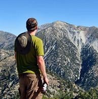
The Portal was a beautiful place, we stayed and soaked in the views for a few minuets before setting off for camp.

Me

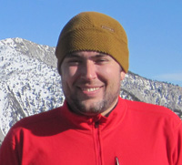
Payne

FINALLY we set off, we had previously decided not to break until we reached Lone Pine Lake. Even early in the trail marvelous granite rose thousands of feet, from each side of the valley, these pictures do no justice to the scale of mountains and men. I loved it here.


We were making great pace, fairly quickly we had reached the John Muir Wilderness Boundary. We took no oppurtunity to rest and continued on at our own pace, 45 lb packs were quite new to us. As we climbed higher views down to Owens Valley began to open up, we ran into the second waterfall of the trail, although this one was more like a slide, and soon enough we had reached the Log Crossing.


We reached Lone Pine Lake shortly there after, walked around to the far end of the lake and had a nice long break. We looked ahead up the valley trying to figure out our path with our map. Together we enjoyed the far side of the lake to ourselves, we had some of our home made beef jerky, set our packs on our backs and continued. You can definitely tell your starting to get above the treeline as soon as you leave the lake. Although elevation was not playing a factor on our bodies yet.


After we left Lone Pine Lake we quickly reached the edge of the Whitney Zone. At this point all I could think was how glad I was to have of gotten a permit and to be here! Our next stops would be Big Horn Park, Outpost Camp, and Mirror Lake. From here on major peaks started really coming into view, Thor peak, Wotons Throne and Mt. McAdie especially.

Dananananana, you are entering The Whitney Zone Dananananana

Looking back at LPL

Finally getting to some fun parts of the trail with minimal but fun exposure...

Entrance to Big Horn Park

Outlet stream of Big Horn Park

Wotons Throne (I Believe)

Gorgeous Rock

I was surprised to see as much water as I did knowing it was a very Dry year. I'd love to see some of these places on an average year.

Waterfall by Outpost Camp

Outpost Camp

After a couple of switchbacks after Outpost Camp you reach Mirror Lake, which was an absolutely beautiful Alpine Lake. We rested for a little bit here and even decided we were making such good time we took a short nap, as it was just too relaxing to pass up the opportunity.


Payne Studying the Map

The switchback past Mirror Lake are awesome, offering some exposed views back down to Mirror Lake and a good amount of elevation gain. After this I knew Trail Side Meadows would be coming up soon, so with our bodies rejuvenated from our nap we pushed on.
Looking back down to Big Horn Park, Lone Pine Lake, and Owens Valley.

On the switchbacks above Mirror Lake, Trail Crest, Mt. McAdie and Mt. Muir all coming into view.

Looking down at Mirror Lake

Stunning Scenery

Trail Side Meadows was beautiful, especially as it was framed by the Sierra Crest.

Payne resting at the Meadows

Me resting at the Meadows


From here at Trail Side Meadows I knew it was a short distance to Consaltation Lake and very shortly after that our camp for the night.
Consaltation Lake was mind numbingly beautiful...

Consaltation Lake, Mt. McAdie, and Payne

The 99 Switchbacks, Mt. Muir, and Me heading to camp.

WE MADE IT TO TRAIL CAMP!!!!! We walked around the area for a bit and found what we thought looked like a nice place, we made our way down there, just north of the stream near the eastern side of Trail Camp. The views here were absolutely phenomenal.
Our Campsite at 12,000' Trail Camp

Checking out what will be the first part of our hike in the morning, The 99 Switchbacks

After we soaked in the views we set up our tents, each of us had our own two person, and began to boil water for tomorrow. While our first batch of water was cooling down we took this oppurtunity to explore. We made our way up and over a rock structure that was as wide as a football field and led down (east) for what looked like a mile. We walked down this for a bit where we had fantastic views of just about everything. We drank our beers, which the elevation definitely messed with, and went back to camp. It was starting to get a little bit chilly. When we got back we boiled up more water to cook our dehydrated dinners with, I had Terriyaki Chicken and Rice and Payne had Three Cheese Lasagna. We were soo happy when we ate. After that we enjoyed watching the sun fall behind the mountains, we boiled one last pot for drinking water, and by 8 were in the tents falling fast asleep.


Throughout the night, I was tossing and turning in my sac, trying to catch as much sleep as I could. The wind at Trail Camp continued to occasionally wake me up. I guess Payne woke up at one point in the middle of the night with what he thought might be the beginning of Altitude Sickness. Luckily he woke up just fine.
The next morning, it was cold. This was the one thing we had under-prepared for. Thinking that it was July and it had been a dry winter led us to assume it would be warmer, but in the morning that bubble was immediately burst. I believe we awoke around 5:30am to catch as much of the sunrise and the Alpen Glow as we could. I was sourly dissapointed the night before when I knew we would not be able to see Mount Whitney in the Alpen Glow. Oh well, I guess that means I have to go back for the Mountaineers Route.


As the Alpen Glow rose we became star struck. we watched it until it was gone, stunned at how much more brilliant and long lasting it had been than the one we had seen on San Gorgonio. My sour disappointment went away as we had a great vantage point of Mt. Muir, another 14er we had planned on climbing, but we forgot to bring all of our beta, and maps, for the 3rd class summit block.

Cold...

This is how we stayed warm while making breakfast...

After the Alpen Glow was for the most part gone, we cleaned up our camp, packed our summit packs, and hit the trail by 6:30. Thunderstorms were threatening the next days weather and sure enough some clouds had slipped in compared to the previous blue bird day. Although these clouds didn't help keep us any warmer, they did provide some beautiful lighting.

Getting more around the corner of Wotons Throne, to a better view of Whitney.

The 99 switchbacks definitely looked more intimidating in person. Which only got me more excited, I have been eager to experience some more wild exposure. I found the switchbacks quite entertaining, we went at a pace of 11 switchbacks at a time. The lengths of those sets of 11 change drastically, and the last 11 switchbacks are no doubt the longest. Despite a much slower pace, compared to our 2.5 - 3.5 mph, we passed many people. Many we stopped and chatted with for small bits of time, many we ran into more than once. We were all stopping as an excuse to break though, the elevation was most definitely starting to kick in. From switchback 1 to switchback 99, we counted, all the way up to Trail Crest, our views became increasingly more dramatic.

Views back down into Owens Valley and down to Trail Camp were fantastic as we moved up the switchbacks.

One of the Needles poking out and Mt. Russel in the background.

Despite the beautiful weather we were still cold. Mt. Muir Left, Keeler Needle Right


I was pretty surprised when we got to the cables to see 1. How early in the switchbacks they were and 2. That they only last for 1, maybe 1.5 switchbacks. We stopped for a moment to enjoy the exposure and take some pics.


Our first view of Whitney

Trail Camp

On the last few switchbacks

When we got to Trail Crest at 13,600 were we so happy and the views which now included West were phenomenal.


View of Muir, the Needles, and Whitney from Trail Crest


Views west and Guitar Lake

Heading onto the west side of the mountain was great. The trail turns into a whole new world with some great exposure west until you pass Mt. Muir. Two miles from Trail Crest to the Top. it was 8:30am.


West

Exposure


The Top

The top was in our sights, our pace quickened, was passed many resting, and only right before we caught a glimpse of the hut did we stop for a quick break. A hiker coming down trying to fix his hiking pole told us we were close. We pushed on, and we made it to the highest point in the contiguous United States, Mount Whitney, 14,505'.
We signed the summit register, and jumped into the hut to get out of the wind. We rested for about 20 minuets before even going the last 20 feet to the top. We signed the roof inside, read many of the other signatures and met two other kids from New York about our age who had just completed the John Muir Trail. We chatted with them about our adventures when another friendly hiker who had come from Bishop Pass came inside. We joked around for a bit, and then Payne and I went to the Top.


This being my first Sierra Nevada Peak, and the first time Payne had ever experienced any sort of back country Sierra travel, the views at the top had us both dumbfounded.

Another one of my goals, to climb in memory of my Grandpa Russ who loved the Sierras, Mt. Russel

Ice Berg Lake

View North

View West

View South

We climbed down about 5 feet over the east face to this ledge where we had a perfect seat and view down the East Buttress. We even spotted some climbers heading up, so we yanked out our victory beers, and watched the climbers climb while gawking at the views down to Owens Valley.


Can you see the climber?

Can you see him now?


We left the top at around 11:00 made it back down to Trail Camp safe, packed our still heavy but slightly lighter bags, and went for the Portal. Because of how many stop points there are along the trail ie: The Top, Trail Crest, Trail Camp, Trail Side Meadows, Mirror Lake, Outpost Camp, Big Horn Park, and Lone Pine Lake, the hike down was not all that bad. The last 2.8 miles though became endless as switchbacks just seemed to be the enemy of my knees, and Paynes Andoid GPS App claimed we had gone 3 miles in only about a mile and a half. From Lone Pine Lake to the Portal the app recorded we had gone 5.5 miles. I trusted my Tom Harrison topo map a bit more, so that argument lasted all the way to the bottom. Besides that we had somehow began to chant crazy things like "Jack in the Box" as if we badly wanted water in the desert.
When we got to the bottom we weighed out our bags, we had each dropped exactly 10Lbs and were asked by two Canadian girls to give them a ride down to Lone Pine. The four of us jumped in the truck and went down to Lone Pine, we ran into the 2 New Yorkers again and we all had one last word with each other. We immediatley got Gas, the biggest Dr. Peppers we could, and set off to find the nearest Jack in the Box. Oh but that was after 30 min out of Lone Pine we realized we still had the Bear Box
Overall the trip was everything I hoped it would have of been, except longer. The mountain and the trail and the people were exactly what I needed before I started another crazy hectic quarter of school. Just one more reason to grow my love for the Sierras.