I had recently visited this river, but foolishly thought it would be a time for me to snap a picture of Falls Gulch. A few new landslides, terrain oversatuated with water...just like 2005. I might have reached the bridge in 2.5 hours...not sure. No one was out for bungee jumping, go figure. An almost fall on one of the river crossings finally convinvced me Falls Gulch was out of the question for a dayhike. Thought I would go to the ***pristine**** zone instead, a slow hike to there indeed. First sign of trouble was a gatorade bottle left behind, not a biggie, but more sad than anything else. Finally some hardware installed for no reason by a . If anyone has any ideas how to remove stuff like this let me know....anyways a lot of trash around. I didnt see a sign that said "Needs trash".

On the way back, a photo of BTN canyon for my previous TR...

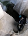
A video of the Narrows crux. I dont have to say anything about how the SG river can be potentially dangerous do I? Jackson Lake, thin ice, DONT GO ON THE ICE if you arent prepared for what could happen,that kind of thing?....
http://s2.photobucket.com/albums/y30/ni ... C_0031.flv[/u]