It can be a dangerous endeavor, hunting for these old trails, which tend to be obscured by heavy brush, sometimes washed away on steep slopes, or buried in rockfall along precarious cliffs--just to name a few inherent dangers. With the summer heat wave, such an endeavor becomes even more dangerous, and so I very much thank the SAR teams for doing the difficult job of searching for Colin in extreme conditions.
I believe Colin went hunting for an old, abandoned trail, not only in a difficult place to reach, but also in a portion of the forest currently affected by a federal closure order. It's not clear whether Colin knew that the area was still closed, but we might take a lesson from this scenario. If you go missing in a closed area, your friends can't help search for you on the ground, unless they are willing to enter the closed area too and risk being fined.
Yesterday I felt useless as an information resource, so I decided to go on a hike/search. I had been entertaining longshot theories, one of which is that after getting into trouble Colin tried to reach the West Fork of San Gabriel Canyon. My plan, therefore, was to walk down the fire road from Red Box to West Fork Campground, and return via the Gabrielino Trail.
Due to a commitment in the morning, I couldn't start until 1:00 pm. This put me in the midday sun on an exposed fire road, but I was prepared. I completely covered up and brought extra water to stash at Valley Forge camp. I also brought a filter in case I needed more water. As for returning via the Gabrielino, I did not know the post-fire condition of the trail, so I brought tools just in case a path needed to be cut.
Starting down the Red Box-Rincon Road, I had occasional shade. The road itself was in great shape, recently maintained. I heard a noise to my right and a deer stood about fifteen yards from me on the slope. I tried to befriend it with gentle conversation, but the shy animal bounced away.
At Camp Hi Hill, the creek was flowing across the road. Indeed many of the tributaries still contain water. I frequently stopped at the side canyons to cool down and soak my head, hat and bandana in cool creek water.
I stood at the closed gate of Hi Hill, once known as John Opid's camp. I yelled, "Colin!"
From there the road moved to the sun-beaten side of the canyon.
It was hot, and sometimes it seemed like entering hell (not that I'd know the experience firsthand), but I also saw things of paradise.
The dry and dusty path was divided by periodic trickles of water, coming from narrow, green canyons on my left and joining the main courseway on my right. This water kept many plants and trees alive, while in other places big trees had succumbed to the Bobcat Fire in bunches.
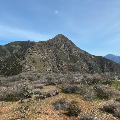
As the views down canyon opened up, I could better appreciate the mixture of the burned and the unburned. The old growth, and the new growth. The little singletrack along the creek, and the big, dirt road along the slope. The deer that fled from me, and the lone fly that wanted to get under my skin--literally. Thankfully the bugs weren't much of a nuisance, though I may have swallowed one dive-bombing gnat.
I frequently paused to scan the hillsides and canyon bottom, finding nothing of great relevance.
Those who fixed the road had marked unstable edges and had left a couple ropes behind. A boot print here and there, mostly tire prints from mountain bikers.
I reached Valley Forge camp and took a break in the pleasant shade of trees which had survived the fire. There was an old fire ring made of stone, built by Boy Scouts in 1988.
The pit toilets still stood proudly. I invaded one that had become a sanctuary for spiders. I do not apologize for disturbing their peace. I am at war with the spiders. They drew first blood, not me.
For a camp that got hit by the Bobcat Fire, Valley Forge is looking good. It's even stocked with toilet paper. A trail sign or two burned up, but that's about it.
I stashed a gallon of water under a tree and moved on. More hot road. More blending of heaven and hell. I enjoyed the scenery until the road dropped into the creek bottom.
Then I enjoyed getting my feet wet at the concrete-lined crossings. I hike in water sandals these days, so I'm prepared with plenty of spare socks. After the crossings, I changed into fresh socks at West Fork Camp.
A couple interesting features between camps are this road cut through rock,
and a cienega that spills down the road a short ways, supporting a lush hillside.
At West Fork Camp I posted a flier for Colin and looked around the site.
I also checked the beginning of the Shortcut Canyon Trail, but found nothing helpful.
The camp didn't burn at all, and appeared in excellent condition. I took a break to eat and drink something, then started up the Gabrielino Trail.
There has been much clearing and restoration along the Gabrielino.
The trail is easy to follow between West Fork and Valley Forge, except that the junction with Kenyon Devore is rough, overgrown and unsigned. You could miss it in the dark. There are also narrow spots along steep slopes and poor crossings at some of the tributaries.
It appears that the trail work was done a year or two ago, as fresh poodle dog is creeping next to the trail. In some places one must take care not to brush up against it.
Also, many stalks of the snapdragons bend across the path.
As I climbed above rocky side canyons, the views became more impressive. The route passes under the north face of Mt. Wilson,
and along one stretch I was able to view Mt. Baldy in the distance. I couldn't recall ever walking this portion of the Gabrielino, but I probably did once or twice, not fully appreciating its beauty. Even in its half-burned state I consider it a beautiful stretch of the canyon. I see why so many people built camps along its banks.
The Valley Forge trail junction burned, and the trail to Eaton Saddle looked unwelcoming. The path down to the camp, however, has been cleared and is in okay shape. I retrieved my water cache and returned to the Gabrielino. It was 7:48 PM.
I had been going very slowly the whole afternoon, looking around and taking notes. Now I had less than an hour of sunlight, with 2.3 miles remaining. I quickly passed through the cabin district, checking inside cabin 20 which survived the fire and has an open door.
Other cabins were locked. Putting on my headlamp, I pushed through an overgrown section of trail that runs along the stream. This stretch needs a lot of love.
There are rudimentary log crossings, and the water flows down the trail at one point. Plus it's hard to see your feet due to the overgrowth.
I passed a confusing sign that says "Valley Forge Campground." I wondered why the sign was placed so far away from the actual camp. In the dark I hadn't noticed the small, hand drawn directional arrow between the big words.
I finally crossed the fire road and began the final push to Red Box saddle. Feeling slow, I grinded up the headwall. I hadn't eaten much since lunch. I was saving my appetite for a big dinner at McDonald's.
It's amazing how high up this canyon pools of water can still be found. I suppose they'll dry up before summer is over.
I reached the car at 9:30 pm. From the turnout beyond Red Box I could see across the canyon toward the main search area. Four little lights launched into the air, probably drones with special capabilities. Headlamps on the ridge. Headlamps on the hillsides. The search for Colin was continuing through the night.