
I've been chasing wildflowers and someone suggested a trail that I should check out. This was a trail that was seldomly traveled. It starts at Forest Road 3N48 in Little Tujunga.
The weather was overcast and it was a great day to hike for what was unexpectedly ahead of me. From the start of my route there were tall sunflowers along the road and a bee farm. I could hear gun shots from the neighboring shooting range. After leaving the road, I took the ridge route which was overgrown but surprisingly filled with wildflowers such as orange and yellow Poppies, Lupine and other flowers.
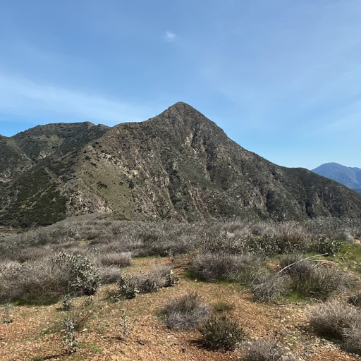
The trail was difficult to navigate in some areas but it was easy to figure out where I was headed. I took my time to enjoy the surrounding views of lush green hills and the beautiful array of wildflowers. It's a 1600+ steep climb with a few switchbacks, but worth every step.
The top of Limerock peak is flat with awesome views. I found a huge wooden cross on the ground with some religious verses (in English & Spanish) and I picked it up and re-positioned it in the rocks. I also placed a new register.
I knew someone had been up there but wasn't sure how long ago because I found some rocks in a circle. Anyways, I made a huge heart with some nearby rocks.
Afterward, I ate lunch and headed down the opposite side making it a loop hike. The descent was very steep, with loose rocks, and I fell twice. However, on this side it was just as beautiful. I found two-toned colored poppies and more wildflowers. I had to descend into the wash below and walk back to the car about half a mile.
This was a fantastic hike! Secluded with tons of wildflowers and not a soul in sight.
LIMEROCK PEAK
-
Girl Hiker

- Posts: 1318
- Joined: Fri Apr 04, 2014 7:46 am
Lovely! I think this area last burned in 2017(?) in the Lake(?) Fire, so its definitely great for wildflowers. I've hiked around Limerock pretty extensively, as it is within my "radius" (at some point I'll make a post about that methodology...)
I recognize that little grove of pine trees, its a lovely spot in the foothills. Lots of trails around there. Would you have a screenshot or something of what your route was?
Screenshot attached of the hikes I've done around there. (Myself or my wife give them names as you can see )
)
I recognize that little grove of pine trees, its a lovely spot in the foothills. Lots of trails around there. Would you have a screenshot or something of what your route was?
Screenshot attached of the hikes I've done around there. (Myself or my wife give them names as you can see
-
Girl Hiker
- Posts: 1318
- Joined: Fri Apr 04, 2014 7:46 am
Nate
This was my route. We deviated into the wash (on the right) just to check it out. But it's really not safe to be in there. So don't follow that part of the track. Just follow 3N48.
This was my route. We deviated into the wash (on the right) just to check it out. But it's really not safe to be in there. So don't follow that part of the track. Just follow 3N48.
Thanks so much! I didn't realize there was a trail right up the face of Limerock, but I see it now on satellite imagery. Nice loop.Girl Hiker wrote: ↑Nate
This was my route. We deviated into the wash (on the right) just to check it out. But it's really not safe to be in there. So don't follow that part of the track. Just follow 3N48.
Limerock pk 4_17_23 9_21_55 AM(1).gpx