Our goal was to take Idlehour Trail down to Eaton Canyon, hang out for a bit, then Cecelia would go back solo the way we came. I would spend the night and hike out on Saturday through Henninger, and Cecelia would pick me up at the Pinecrest gate.
At Five Points there were two parked cars. Cecelia later told me that she met the owners on the way out. They were installing new signage. If you've hiked around Echo Mtn. or Mt. Lowe recently, you've probably seen some of these new signs. Here is an example at the Mt. Lowe West Trailhead.
After a snack break we continued down the Idlehour Trail, which clearly hasn't seen much love in awhile. But it's still a nice, gradual descent with some pretty scenery as the name indicates.
Cecelia got her fill of the water after crossing the tributary, which was flowing nicely, and after reaching the final ridge looking down into Eaton she decided to turn back. So we said our goodbyes, and I continued down to Eaton creek.
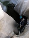
I did some scrambling up the canyon and found a place to camp for the night. The water was flowing very well. I drank plenty of it without filtering, and still feel fine. Yes, I live dangerously. I didn't see any large animals, and the night was very peaceful.
The next day I hiked out through Idlehour Camp, where Larry and the Valencia Hiking Crew were celebrating a birthday. I used to hike with the VHC and I recognized one of the people in the group. After chatting for a bit, I started up the trail toward the Mt. Wilson Road.
Being out of shape, this was the toughest hike I've done in a long time. My feet and back were complaining loudly. So I went at a very slow pace and took a few breaks to rest and take in the up-canyon views.
After cresting one of the ridges, the trail contours across several gullies with old retaining walls.
I finally crested the last ridge and dropped down to the road and then to Henninger, where I was greeted with a bunch of signs.
I called Cecelia from Henninger to let her know I was alive. Then I slowly made my way down the road, stopping only once at a shady bench that was calling my name.
At the Pinecrest gate there is another sign that caught my attention, because it's going to be the name of my future progressive folk metal band.