
AllTrails clocks this at about 6.9 miles with around 2000 feet of elevation gain.
Snow on Smith
Another Plan B day for me, I was planning to go up and visit Mt Islip but the road was icy after the Crystal Lake turnoff and traffic was at a standstill. Since I had already made the investment of time to drive up Azusa Canyon, I retreated to the Bear Creek trailhead, happily finding only four cars in the lot. There was a little bit of burn area above the trail, along the drive up I had noticed how the fire stopped abruptly at the road in places. Since it had been a while, I forgot how steep this trail is in the first mile but after that things are really nice walking through the inner canyons as the route winds around in and out in a gentle slope to Smith Saddle. Once I got there I was struck by the smell of fire, as plenty of shrubbery was reduced to dark sticks. It's really pronounced there, as one side is brown and the other side is green. I took a brief break to don the microspikes and headed up the snowy north flank of Smith Mountain. A few times on the way up I thought about how difficult this might be on the way down, yet I kept heading upwards. I'm not sure at what point I would cross the less than safe-for-solo threshold, although I may have danced along it. The brush on this slope was all burned, although still hardy enough to provide hand grips to assist in the climb, and a pretty good boot track guided me up. It was also a good thing to wear long pants, as plenty of thorns were grabbing my legs as I powered through them. Just before I reached the summit a group of four people headed down, no masks, and the guy in the lead didn't stop to let me pass, just hopping onto and across the same rock I was standing on. Jerk - don't you know uphill has priority? Obviously not! Anyway, the summit was nice, the big bush on top was still green although quite a bit was burned around it. I sat up there a while to contemplate life and a hopefully better year than 2020, and yes I used my Jetboil for some hot chocolate to go with the pop-tarts for snack time. Going down was a little interesting as the snow was a little slushier which jams up the spikes and makes things slippery. I used my poles a few times to knock the snow out of them which definitely gave me more confidence on the steeper section.
AllTrails clocks this at about 6.9 miles with around 2000 feet of elevation gain.
Trailhead. The dried grasses below the burn were confusing.
One mile in, summit ahead. The way this trail winds around the hillside makes distance deceiving.
There were a few icy sections of trail in the shady spots.
Almost at the saddle so I can see the snow travel ahead.
View from the saddle at the fire devastation. I figure this won't come back in my lifetime.
Heading upward through what is now a stick forest.
This last section is much steeper.
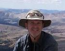
Summit pose, legs were a little too dead to hop up on the benchmark rock.
Looking toward Islip, Windy Gap, Hawkins et al through the summit burn.
Baldy just because I like the view.
AllTrails clocks this at about 6.9 miles with around 2000 feet of elevation gain.
Trailhead. The dried grasses below the burn were confusing.
One mile in, summit ahead. The way this trail winds around the hillside makes distance deceiving.
There were a few icy sections of trail in the shady spots.
Almost at the saddle so I can see the snow travel ahead.
View from the saddle at the fire devastation. I figure this won't come back in my lifetime.
Heading upward through what is now a stick forest.
This last section is much steeper.
Summit pose, legs were a little too dead to hop up on the benchmark rock.
Looking toward Islip, Windy Gap, Hawkins et al through the summit burn.
Baldy just because I like the view.
"Argue for your limitations and sure enough they're yours".
Donald Shimoda
Donald Shimoda
Nice hike and good way to start the new year!
Looks like the direct approach to Triplet Rocks from the east will now be "doable" as well as Mermaids and other hard to reach destinations. Not sure if I'll have the time, opportunity and nerve to make it to those destinations.
The shot to the west reminds me of the way things looked after the Station Fire. 11 years later, much of the Station burn zone has recovered better than I expected - many oaks that looked like charred toothpicks sprouted again and the chaparral is closing off cross country travel again. A new crop of ash trees in the canyon bottoms is providing a nice canopy, so it will be interesting to see how things fare in the Bobcat fire zone going forward.
Thanks!

I didn’t see any closure signs, and I stopped to read all the stuff at the map/information board. Google Maps says that it is closed.
Next time up that way I plan to turn right at the saddle and go up that higher peak, is that the route you are planning from the north?
Next time up that way I plan to turn right at the saddle and go up that higher peak, is that the route you are planning from the north?
"Argue for your limitations and sure enough they're yours".
Donald Shimoda
Donald Shimoda
-
Girl Hiker

- Posts: 1327
- Joined: Fri Apr 04, 2014 7:46 am
Nice pics. When we were there on New Years day I wanted to check out the ridge route to Smith from the closed gate at hwy 39. As we hiked up the road the smell of the burned area made me a bit nauseous. It was pretty bad the further we hiked up that road.
You are so fortunate to hike up Sunset and Smith peaks in the snow. I never get that opportunity.
You are so fortunate to hike up Sunset and Smith peaks in the snow. I never get that opportunity.
The opportunity is always there, it's a matter of taking it.Girl Hiker wrote: ↑..... You are so fortunate to hike up Sunset and Smith peaks in the snow. I never get that opportunity.
Any time you want to venture to my side of the mountains just let me know...
"Argue for your limitations and sure enough they're yours".
Donald Shimoda
Donald Shimoda