
Guess the trail name!


Well I have no real idea. Never heard of an explicit trail name for it, and haven't been on it in case there was an old trail sign.
But I believe presumably it is the old target path for the old Road to Nowhere? Aka Convict Road?
So my guesses are:
Devil's Gulch Trail
Iron Fork Trail
Shoemaker Canyon Trail
Road to Nowhere Trail
Convict Trail
Lowline Trail
South South South Mt Hawkins trail
I Have No Other Clue Trail
But I believe presumably it is the old target path for the old Road to Nowhere? Aka Convict Road?
So my guesses are:
Devil's Gulch Trail
Iron Fork Trail
Shoemaker Canyon Trail
Road to Nowhere Trail
Convict Trail
Lowline Trail
South South South Mt Hawkins trail
I Have No Other Clue Trail
I believe the Highline trail is the thing that wraps around Iron Mt, on the other side of the river.
Actually it's not related to the road through the tunnels, I want to say that this trail is older than that road. There was some vague plan to dam the river around the Narrows somewhere to generate power, and that's where the trail starts.
Actually it's not related to the road through the tunnels, I want to say that this trail is older than that road. There was some vague plan to dam the river around the Narrows somewhere to generate power, and that's where the trail starts.
Yep. "PL&P" is "Pacific light and power", so this was related to the dam they were considering. I don't remember where I read this, but looking for it just now revealed a number of references to the old trail system, such as this (LA times 1937/08/22):
And there's still and old sign near the bottom end:

And there's still and old sign near the bottom end:
Nice! Apparently Hiking Jim said the trail past Iron Fork to Fish Fork was also the PL&P, which I explored a 10 years ago.
So basically I can't even remember the name of a "trail" I was on before. Sad!
Is there any topo map where this trial is named?
So basically I can't even remember the name of a "trail" I was on before. Sad!
Is there any topo map where this trial is named?

Nice I had only seen 1940's available years ago, those didn't have the named labeled (but trail was there).
Yeah I followed it I think maybe 1/2 way to Fish Fork. Most of the way was pretty passable. I remember encountering a massive brush filled, fallen tree, poison oaked gully though that was exhausting to get through.
Thank you for the enlightening history lesson on this trail - if the sign is still there, it must have been an officially recognized, if not maintained trail within living memory. Would you say the sign is from the 70s?
Amazing to think how many trails and routes have been surrendered and left to fade away, though I'm not too surprised about this trail given the meandering path it takes through exposed terrain with apparently no water for many miles.
Also probably because the san gabriels either burn up, get washed away, shed tremendous amounts of horribly fractured rock and dirt or are overrun by impenetrable chaparral if not constantly worked.
The maps make me think that trail was already long-abandoned by then, but the sign is in great condition, so I don't know. Go check it out if you're interested. It's a bit above the start at pt 2612. The trails around there aren't obvious, and it's easier to find approaching on the clear trail cut from the other direction. There's a trip report I can point you to.

Is that the bottle opener on the Ski Hut Trail? I'm guessing it disappeared before I started hiking in 2011. But I also seem to recall a bottle opener on the back of a Baldy sign a little before you reach the final push to the summit.

-
Uncle Rico

- Posts: 1394
- Joined: Thu Mar 20, 2008 7:48 pm
How about Bighorn as you start the ascent to Cucamonga?
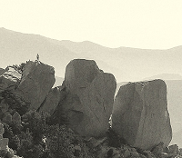
Right peak, wrong side. Picture taken looking east after leaving 7W07. Coming up from Kelly's Camp, turn left to Bighorn, turn right to Ontario.Uncle Rico wrote: ↑How about Bighorn as you start the ascent to Cucamonga?
-
Uncle Rico
- Posts: 1394
- Joined: Thu Mar 20, 2008 7:48 pm
Ok, this one's probably pretty easy for y'all. But what trail is this?
PCT, near Throop.Uncle Rico wrote: ↑Ok, this one's probably pretty easy for y'all. But what trail is this?
Name That Trail.JPG