
Pine Canyon, the one off of the Altadena Crest trail. Does anyone know if it's possible to ascend all the way from the base of the canyon to a peak?
I passed through the west side of the canyon the other day coming from Fuji and could swear there was a trail high up on the east side of the canyon, but I couldn't tell where it came from or connected to. Looking on Google Earth I can see the faint outline of something.
I've tried to ascend from the mouth of the canyon, up past the three concrete walls, but haven't gone further than where the dry waterfalls start.
I know there are some old gold mines in the area. Figured maybe someone had developed a through route to the top at some point.
Pine Canyon

Not sure how "high up" the trail you saw is, but there is an old road grade that traverses across the east wall of the canyon (a continuation of the road grade you were likely walking on your way down from Fuji). It wraps around to the east below benchmark Mt. Lowe 2820.
Other than that I don't know anything about a trail. Maybe Sean does.
Other than that I don't know anything about a trail. Maybe Sean does.
I think the old road grade was the SCE road to access the power lines and towers when they were built? It seems to be washed out near the head of pine canyon but you can see it contour under the power lines around the east shoulder to somewhere above Eaton Canyon.
I once ascended Pine Canyon from the bottom, up the check dams to where the dry-falls start. That's where you can find the mine tunnel into solid rock on the east side, I think it's Surprise mine? When I was there, there was a fixed rope hanging into the canyon from the west, right when the power lines are directly overhead. I decided to follow the rope. It led up the west slope to a gravel pile where somebody had left a bunch of shovels and buckets. Prospectors? You could ascend on very crumbly gravel slopes through the bushes and yucca to the old road grade and the lone tree network of trails, but it wasn't a very pleasant route to take. I'm not sure if you follow the canyon bottom if you can go all the way to the road grade. It looks like the canyon gets steep and narrow after the dry-falls.
I once ascended Pine Canyon from the bottom, up the check dams to where the dry-falls start. That's where you can find the mine tunnel into solid rock on the east side, I think it's Surprise mine? When I was there, there was a fixed rope hanging into the canyon from the west, right when the power lines are directly overhead. I decided to follow the rope. It led up the west slope to a gravel pile where somebody had left a bunch of shovels and buckets. Prospectors? You could ascend on very crumbly gravel slopes through the bushes and yucca to the old road grade and the lone tree network of trails, but it wasn't a very pleasant route to take. I'm not sure if you follow the canyon bottom if you can go all the way to the road grade. It looks like the canyon gets steep and narrow after the dry-falls.
Interesting! Yeah it does appear to be a continuation of the tractor road where it takes a sharp right into the canyon, and then follow to the sets of electrical pylons further east.
Out of curiosity I tried to hike up and get a different angle on it. Headed west on the Altadena Crest trail from the Glenallen Ln. entrance, at the first ridge took the firebreak all the way up to the top, and then scrambled up to the electrical towers there.
Directly north of the towers there was a definite clearing, about a two-foot wide path heading two different directions, one of which was back into Pine canyon. There were a couple of items of trash around that looked fairly old, so people had been there before at some point.
The path was fairly overgrown from that point out so I didn't explore any further. Part of me wonders if there would be a way to keep ascending to W. Fuji along its east ridge from that direction, but you would probably have to really love bushwacking to find out.
-
CrazyHermit

- Posts: 343
- Joined: Mon Sep 07, 2015 1:03 pm
I've been exploring Pine Canyon as well, looking for the same possible trail you are. There is a branch of the old Lone Tree Trail which starts in Rubio Canyon and does go down into Pine Canyon just before the you reach the power lines. It heads down to an old sunken cement water structure and shortly after that the trail becomes washed out. If you keep following it you can climb down into Pine Canyon, but unfortunately it ends just slightly above the dry waterfall behind Surprise Mine. After that the canyon becomes horrific, massively overgrown and extremely dangerous.
Nevertheless I kept climbing, up to the point where you actually see some pine trees. At that point it became suicidal to continue, so I turned back.
Alternately on another try I hiked up to the top of Fuji from Rubio Canyon and tried to climb down, which was equally horrific. To date I have never found any of the five mines other than the Surprise.
Good luck with your search. I'd be very interested in knowing how to get there if you ever find out.

Sorry about the late response. I'm not very good about checking this subforum.
You can access Summit, Carrie, and (what I think was) Pine Tree mines from the Lone Tree Trail. It's a fairly simple task getting to Summit, a class 2/3 scramble to Carrie and Pine Tree, although I've been trying to improve the old miner's trail to the Pine Tree site.
Summit is an exploratory dig, less than ten feet deep. Carrie was actually worked a little and goes back roughly a hundred feet. It contains junk from a hermit who used to live in there.
Over three years ago I discovered what I suspect was the Pine Tree site. It does not appear to have been worked very much. There is no substantial hole--but the rock face appears to have been disturbed in a manner consistent with other mine openings. Also there is an obvious debris field immediately below the site. And there were obvious trail fragments leading to it.
If anyone's interested in more details and a map, you can personal message me.
Oh, and the "trail" on the east side of Pine Canyon is actually the old SCE Tractor Road which began in Rubio Canyon, climbed eastward into Pine Canyon, crossed the stream, then continued eastward as described by HikeUp.
The roadbed is in terrible condition within Pine Canyon and is completely washed out at the stream crossing. Beyond that I have no experience. The best approach is probably down from West Fuji and the "Mt Lowe" benchmark ridge. I've heard of people bushwhacking up from the Altadena Crest Trail, but personally I'd rather stumble downward through that sort of crap.
I've also ascended straight up Pine Canyon from the ACT to the lower mine. But beyond that the canyon bottom looks gnarly. I escaped stage-left up some stupid gully to the SCE road.
-
stonehillnews
- Posts: 72
- Joined: Thu Dec 15, 2016 1:31 pm
This fall I've spent quite a bit of time rebuilding the washout, which was possible to find in the brush, but even with the brush cleared, was a technical class 4. After a couple months of concerted effort, it is now a solid class 2 (in my opinion).
West bank of Gooseberry, looking northeast towards the crossing
West bank of Gooseberry, looking northeast towards the crossing
West bank of Gooseberry, looking northeast towards the crossing
West bank of Gooseberry, looking northeast towards the crossing
Gooseberry crossing, looking back along the west bank approach
Gooseberry crossing, looking up along the east bank trail
Gooseberry crossing, looking up along the east bank trail
West bank of Gooseberry, looking northeast towards the crossing
West bank of Gooseberry, looking northeast towards the crossing
West bank of Gooseberry, looking northeast towards the crossing
West bank of Gooseberry, looking northeast towards the crossing
Gooseberry crossing, looking back along the west bank approach
Gooseberry crossing, looking up along the east bank trail
Gooseberry crossing, looking up along the east bank trail
Stonehill news as in http://blog.stonehillnews.com/ ???
I use your weather station to check out the weather - thanks!
Nice trail work.
I use your weather station to check out the weather - thanks!
Nice trail work.
-
stonehillnews
- Posts: 72
- Joined: Thu Dec 15, 2016 1:31 pm
Yep, one and the same. Glad you enjoy the weather station 
-
CrazyHermit
- Posts: 343
- Joined: Mon Sep 07, 2015 1:03 pm
Check out my new website. There's a section on the Mines of Pine Canyon ...
Lost Mines of Los Angeles County
Lost Mines of Los Angeles County
-
stonehillnews
- Posts: 72
- Joined: Thu Dec 15, 2016 1:31 pm
What to you all think about obscuring the coordinates for Carrie. It's dangerous and it's fragile. For a while the coords were also posted on Geocaching.com, but the OP of those voluntarily obscured them there, and removed the listing. He told me that was at the suggestion of some others. Maybe this one is best left to those with the wherewithal to find it the old fashion way.
-
CrazyHermit
- Posts: 343
- Joined: Mon Sep 07, 2015 1:03 pm
Point well taken, and I thought of that in advance. Going by those GPS coordinates will not get you to the mine. I purposely skewed them by a few hundred feet, but I may remove that one altogether. Thanks for the suggestion.
Very nice site! You're probably right that Pine Tree is level with Carrie, and the "indent" I found was something else.CrazyHermit wrote: ↑Check out my new website. There's a section on the Mines of Pine Canyon ...
Lost Mines of Los Angeles County
BTW - There is another tunnel in Pine Canyon which I don't think appears on your site. I crawled into it a couple years ago. Not much inside except an old rug.
-
CrazyHermit
- Posts: 343
- Joined: Mon Sep 07, 2015 1:03 pm
That mine you crawled into was dug out by a guy named Bryant. It's an unrecorded mine, but I believe it was intended to be a water tunnel to power the mill, which was unsuccessful. I think Bryant used that rug to drag out dirt while he was widening the opening. You can see a video of it here.

So. Today, I explored pine canyon for a bit. I have been through three of the mines in the canyon prior to today's exploration. Me and my brother re-excavated Bryant's exploratory mine.
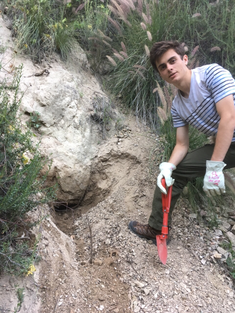
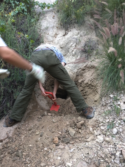
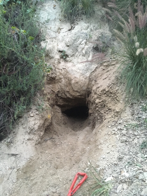
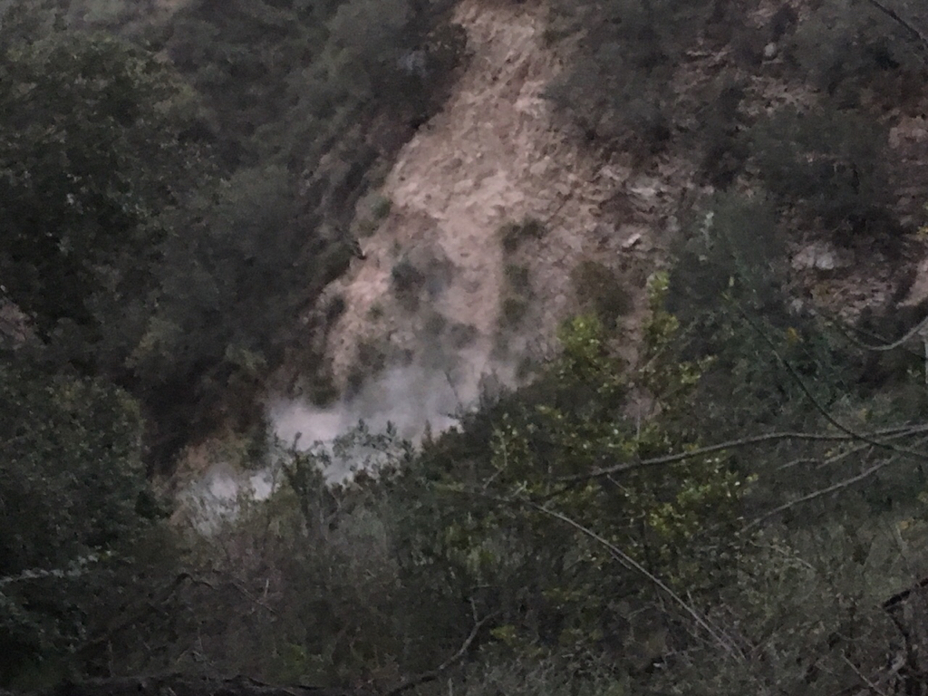
When I came across it, it was completely hidden by dirt and debris. The mine still had the same junk in the back as before. Why am I writing this post about this irrelevant hike? Well. After we got put of the mine, my brother and I began to walk back out when we heard a sound like birds flying. About 200 feet to the left of Bryant's mine was a massive landslide which happened before our eyes! A huge chunk of the canyon wall fell out, crashing on the ground creating a massive cloud of dust!!!! We all were caught in awe wondering what would have happened if the landslide occurred above our heads exploring the mine.
Just wanted to share that. I'll wear a hardhat next time.
jeko1034 wrote:After we got put of the mine, my brother and I began to walk back out when we heard a sound like birds flying. About 200 feet to the left of Bryant's mine was a massive landslide which happened before our eyes! A huge chunk of the canyon wall fell out, crashing on the ground creating a massive cloud of dust!!!!
-
stonehillnews
- Posts: 72
- Joined: Thu Dec 15, 2016 1:31 pm
Looking up canyon, was the landslide on the left or right wall?jeko1034 wrote:Me and my brother re-excavated Bryant's exploratory mine.
After we got out of the mine, my brother and I began to walk back out when we heard a sound like birds flying. About 200 feet to the left of Bryant's mine was a massive landslide which happened before our eyes! A huge chunk of the canyon wall fell out, crashing on the ground creating a massive cloud of dust!!!! We all were caught in awe wondering what would have happened if the landslide occurred above our heads exploring the mine.
On the left wall. It was small. But just above the second dam you need to climb over.stonehillnews wrote:Looking up canyon, was the landslide on the left or right wall?jeko1034 wrote:Me and my brother re-excavated Bryant's exploratory mine.
After we got out of the mine, my brother and I began to walk back out when we heard a sound like birds flying. About 200 feet to the left of Bryant's mine was a massive landslide which happened before our eyes! A huge chunk of the canyon wall fell out, crashing on the ground creating a massive cloud of dust!!!! We all were caught in awe wondering what would have happened if the landslide occurred above our heads exploring the mine.