
Death March

Lets not hijack another thread.Zach wrote:Wasn't aware you guys had done this already... sign me up for whatever's next.
A
Also, the term "death climb" scares me.
We should make a new post for the "Death Climb".
But, with all of Taco's gear sold, maybe the Death Climb is something as easy as doing Baldy Bowl, but using auto parts for protection, jumper cables for slings, and a few dozen chamois tied off for rope. I think i still have "The Club" i can use as an ice axe.

So, would it be the "Death, Dumb Climb"?TacoDelRio wrote:I still have gear, and would likely not use any pro.

Snow Creek is cool, but honestly, in most conditions, it's a stairmaster. While I'm on my soapbox, I'll say that what draws myself to alpine mountaineering is something more complex than just plugging away. A more complex face with traversing, mixed climbing, rock, snow, and ice, big or small.
North Face of Sugarloaf is a lot of fun, IMHO, and demonstrates my point.
Sorry to be hijackin' yer thread!
North Face of Sugarloaf is a lot of fun, IMHO, and demonstrates my point.
Sorry to be hijackin' yer thread!
Lets plan to do NF Sugarloaf 6.8 days after next snow storm.TacoDelRio wrote:North Face of Sugarloaf is a lot of fun, IMHO, and demonstrates my point.
Sorry to be hijackin' yer thread!

I've decided to attempt the Death March in April or May. Scouting and planning stages are over. Anyone interested in training hikes (starting in January) should private message me.
I have learned a lot from this thread and prior attempts by members of this forum. I thank everyone for sharing their stories.
I plan to acclimate and start from the top of Hawkins Ridge, then proceed eastward to Wright Mountain, south to Baldy, west to Iron, descend to Heaton, ascend to Rattlesnake and South Hawkins, returning to Hawkins Ridge. This loop is about 45 miles with 18.5k gain. 8.5 of the miles are moderate to difficult cross-country.
My goal is to complete the route without stashing supplies, utilizing springs, rivers, and possibly snow for water, and carrying all my food. The math puts me at 24 hours if a rapid pace can be maintained. But that's leaving absolutely no room for error or bonking.


To me that would depend on the heat of the day, I'd guess 6 liters to be safe.
Otherwise you will cramp to no end.
The other thought I have is to avoid doing the "double dip", to me I only want to drop down once at Heaton Flats, I would do everything in my power on planning not to have to do it twice, once there and one between Baden Powell and Wright mountain, that's why I suggested all along to start at Wright Mountain so that you could hike over Wright, Pine, Dawson, Badly, W. Baldy and down to Gun Sight Notch in the dark, then get over to Iron and down to Heaton before it get's hot, then from there go across the wash, up Rattlesnake, up to S. Hawkins, Saddie, Middle, N. Hawkins, Burnham, Troop and on to Baden-Powell then walk down to Vincent Gap and jump in a waiting car. I feel no need to cover the distance between Wright and Vincent Gap but that's me.
Maybe Hikin Jim can jump in and tell us where all the reliable water sources are for all of these areas, I know a few but only a few as I rarely use them I almost always carry my own water in the San Gab's.
Just my 2 cents
Between Wright and Heaton Flat? Nada. There's water down at Fish Fork and Little Fish Fork, but that's miles out of the way on an already brutal hike. Maybe water down by the Baldora and Widco Mines, but again way out of the way. Patches of snow and an UL stove with a Ti pot would be the way to go. Not that I like stoves mind you. 
Anywhere along the E Fork there should be water of course.
The route is a little uncertain (anyone mapped it out on Acme or CalTopo or something?), but no water from S Hawkins to the PCT and no water along the PCT to Baden-Powell. There's water at Lamel Spring as you descend from Baden-Powell. I rate that at two or three stars out of five. Probable but verify first. There's Lilly Spring which is out of your way, but kind of near the junction of the PCT and the trail up from S Hawkins. Multiple people have tried to find it including our own Matt Maxon. Matt is a map-aholic and GPS kind of guy. If Matt couldn't find it, I wish you lots of luck. The PCT water report lists it as a "no show". There's always Little Jimmy, which is rock solid reliable, but that's way out of the way.
At Guffy, there's an old pump house down the backside of the slope toward Wrightwood. Supposedly reliable water there (according to the PCT water report). Otherwise not much between Baden-Powell and Wright except for the visitor center at Grassy Hollow. There are faucets at the group camp at Jackson Flat, but you'd need to verify that they were on.
Not sure about water south of S Hawkins. What's the exact route?
HJ
This is the route I suggest but Sean is planning on connecting all the dots
see map here with spots G, H and Q not actual summits but points along the way for reference markers.
As stated the distance and drop from BP to Vincent Gap and then along Blue Ridge just seems to be "too much" but that's my opinion, I for one hope he can make it all, if I decide to go I might bail on that part
Here is a map of my route, moving in a clockwise fashion from Hawkins Ridge. I've tweaked the path from Heaton to Shoemaker, but it's not worth recreating the entire map.
WATER: My plan is to use the following water sources: Lamel Spring (north side of Baden-Powell), Flume Canyon Spring (near Guffy), and the East Fork at Heaton Flat. I believe I can manage with these three sources. I'll carry very minimal water between Hawkins and Baden-Powell. Then a couple liters from Lamel Spring to Guffy. I'll fill the belly at Flume Canyon and probably carry 4-5 liters between Flume and the East Fork, maybe more if it doesn't look like I'll be able to grab any snow. I'll go to town on the water at the East Fork and grab another 3-4 liters for the trip back to Hawkins Ridge.
If Lamel or Flume are dry in April or May, then I'll have to cancel or stash water. They seem pretty reliable though. I'm not counting on Lily Spring near Hawkins, but if it is running, I'll use it while I'm acclimating.
BAIL-OUT POINTS: I have a pretty detailed schedule, and there are certain conditions that will cause me to end the attempt. I need to reach Baldy on time and with sufficient water for the Iron traverse, otherwise I bail at Baldy. Then I need to reach the East Fork with sufficient food and energy for the Rattlesnake-Hawkins traverse. Also, I should have enough daylight to drop down from Rattlesnake onto the ridge to South Hawkins. Otherwise, I will bail at East Fork.
START/FINISH: I decided against starting at Wright Mtn because it is too close to one of my water sources at Guffy. I want to spread out my water sources so that I take full advantage of them. I also wanted the East Fork as my midway point since it is the most hospitable location where I might find help in case of serious problems. Hawkins Ridge is a good place to acclimate for a day, and I plan on climbing up casually from the highway via Lily Spring.
SADIE & FROST: I'm debating whether to add Sadie Hawkins and Frost Point to the list of peaks I'll hit. Frankly, I doubt I'll add them unless I'm way ahead of schedule.
STOVE: Sorry, Jim, no stove for me.
PCT vs. BLUE RIDGE RD: I'm still debating the best combination of the PCT and Blue Ridge Road between Inspiration Pt and Wright Mtn. The goal of course is to cut down on miles, but also consider gain and ease of terrain.
Right now the plan is to reach Wright Mtn around 6:15 AM. I could meet you there.
So are you going to bivy near Hawkins Ridge the night before, or down in the car by Hwy 2?
And I'd like to see the time frames you are giving yourself?
The section from W. Baldy to Iron is going to need good daylight to make it safe or at least the midsection where the class 4 sections, I'm good with those down them in both directions.
I still do not know how brutal the section from the top of Rattlesnake to S. Hawkins will be, the fire cleared that area but it would be nice to know how clear that full ridge is?
If I commit I might just do the whole thing with you, I'll do some extra training to be ready.
Keep me posted on anything else that you have insight on.
Thanks
lilbitmo/Patrick
Freaking ambitious, dude.
HJ
I know about Sadie Hawkins. What's Frost?
If there's snow, a stove + fuel + small Ti pot can be a lot lighter than water.
HJ
The afternoon/evening before (probably a Friday) I'll set up a tent near Hawkins Ridge. Then for 24 hours I'll try to get as much sleep as humanly possible before starting the next evening.
And I'd like to see the time frames you are giving yourself?
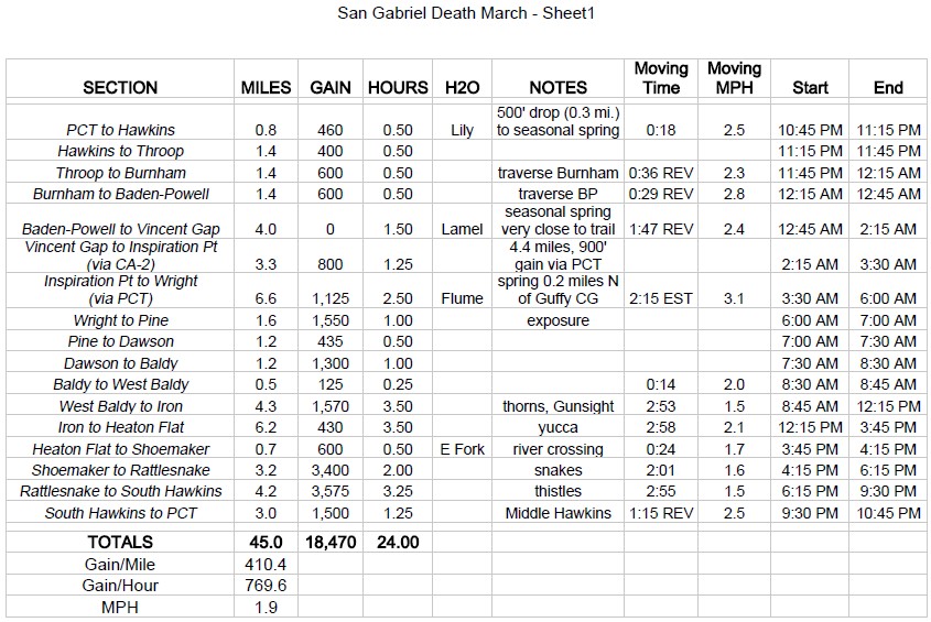
The "Moving Time/MPH" indicate stats from actual hikes along the route. "REV" means I did the section the opposite/reverse direction from my Death March plan.
I'm planning to be on Wright around sunrise, and Iron around noon. I think daylight is important for both the North Backbone and San Antonio Ridge. I'm hoping to have some daylight for Rattlesnake to S. Hawkins as well.The section from W. Baldy to Iron is going to need good daylight to make it safe or at least the midsection where the class 4 sections, I'm good with those down them in both directions.
It's predominantly clear of brush. Some light 'whacking and minor bouldering. The worst was the thistles, and I'm hoping to avoid them in April or May. You can read my full report on the ridge.I still do not know how brutal the section from the top of Rattlesnake to S. Hawkins will be, the fire cleared that area but it would be nice to know how clear that full ridge is?
I see Lilly Spring listed on your spreadsheet. Does Lilly Spring still exist, even in early season? I've yet to talk to anyone who has been able to find it any time in the last several years.
Modern gas stove: ~2 ounces
Small (110g) gas canister: ~7 ounces (full), about 4 ounces of which is fuel and 3 ounces is the canister itself.
1/2 liter Ti UL pot: ~3 ounces
TOTAL: about 12 ounces (3/4 pound)
Just off the top of my head, you should be able to melt about 1 liter for every 10g of fuel in spring conditions which gives you about a 10 liters of water (20+ pounds of water) for just 4 ounces of fuel weight (12 ounces total system weight, not counting a lighter/matches/sparker which I'm assuming you'd probably carry on a hike like this anyway). 20+ pounds of water for less than a pound carried isn't a bad ratio.
There's the rub; it does take time. But on a day where it's above freezing and the snow is already slushy, it can be surprisingly fast.
Your call of course. Just laying out some options.
HJ
I found a spot with a bunch of lilies and moist ground. That was in August. Whether it flows or not remains undetermined, as I have yet to check it in optimal spring conditions. I plan to figure this out before the hike, but still I'm not counting on the spring being useful. If it merely seeps, I might try to build a temporary reservoir.
I also plan to clear brush on the Heaton-Shoemaker connector if anyone would like to help.
Presumably Lilly Spring. Wow, good job. A number of people have tried to find it and have not.
Now that's dedication to a plan. Ain't no way? I'm gonna make one.
HJ

Good luck Sean, that's a big day.
I'm a little burnt from the past three weekends, 9 Peaks, 26 miles on the PCT and then Fish Fork this past weekend so I'm out.
I hope like hell you make it been wanting to see that bad boy checked off for some time.
Like Taco said the TR will be epic
I'm a little burnt from the past three weekends, 9 Peaks, 26 miles on the PCT and then Fish Fork this past weekend so I'm out.
I hope like hell you make it been wanting to see that bad boy checked off for some time.
Like Taco said the TR will be epic