
After being turned down two years in a row, this year I finally got a permit to climb Whitney. The first nine slots I filled in with overnight requests, however we were given our 10th (and final) choice: a dayhike on August 31.
We headed up early Monday morning and had two hikes planned to acclimate. The first was along the first couple miles of the MWT to Lone Pine Lake, which is a simple hike up a few sets of switchbacks to just under 10,000 feet. The lake itself is absolutely gorgeous, I could stay there for days.
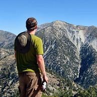
The following day we took our second prep hike about 4 miles up the Meysan Trail to just shy of Peanut Lake at around 10,800 feet. This is a steeper trail and I'm convinced that these two hikes made all the difference in our bid for Whitney the following day.
We hit the trail right around 3:15am and made quick progress up to the turn-off for Lone Pine Lake. It was chilly, probably in the low 50s, and got colder as our elevation increased. The water crossings were easy, and following the trail was straightforward.
Shortly after crossing through Bighorn Park and Outpost Camp, the first signs of daylight arrived. As the mountains slowly illuminated, the stars remained visible, leading to an extremely surreal setting:
This remains one of my favorite parts of the hike.
Shortly after the sun came up, we crossed through Trailside Meadow and arrived at Trail Camp, where we filled up on water and prepared for the dreaded swtichbacks.
Despite the fact that the sun was now up, the temperature here was actually lower than at the start of the hike, probably in the upper 30s. As long as you keep moving, it's not a big issue.
The switchbacks actually went by fairly quickly, as there's no shortage of jaw-dropping scenery 360-degrees around to keep your mind off the monotony of the trail, and this is also where you first see the Smithsonian Hut on the summit, giving you slight hope that you'll eventually get there.
Before you know it, you cross over Trail Crest and the views open up over Sequoia National Park. From here, it's a grueling couple miles to the summit, don't let the 1.9 miles and mere 900 feet of elevation gain fool you. These numbers mean a very different thing at 13,600+
Finally we reached the summit block. This is actually a pretty simple climb up a talus field and when the hut comes back into view, you're basically there.
All-in-all, this was by far the most difficult and most rewarding hike I've ever done. A total of 22 miles, 6,700+ gain, and 16 hours, and we made it back to the Portal with time to celebrate:
Bottom line: as far as Whitney goes, pretty straightforward, no obstacles, no issues with the elevation whatsoever, weather was absolutely perfect (though I would have appreciated at least a few clouds in the sky for pictures), but what an unbelievable experience.
A whole lot more pictures here:
http://www.flickr.com/photos/wattifoto/ ... 586948694/