Owens Peak, southern Sierra, 5.21.10

Archived TRs for Sierra Nevada ranges.
Post Reply
User avatar
norma r
Posts: 707
Joined: Thu Nov 06, 2008 4:22 pm

Post by norma r »

Dave G and i took a warm-up hike on Owens Peak, elev 8,453 feet, in the southern Sierra before we headed to Split Mountain last weekend. Owens affords a great little day hike with a number of different conditions.

Owens is accessible from a dirt road just north of the Indian Wells Brewery on Hwy 14 (a heartbeat south of the 395/14 junction.) You reach the TH after a 45 min drive on the dirt road. You begin on a maintained trail, cross some talus slopes, higher up enjoy some rock scrambling and back to a trail to the summit. The ascent is well ducked. On the descent i prefer to head east just below the summit to an area introduced to me as the Secret Scree Slope. Just west of a striking rock formation a cairn signals the drop in point and there is a maze of rock and shrubs in loose small scree that allows you to scree ski at least 1000 feet. Eventually the scree subsides and you are back on a winding trail that directs you to a small though significant Indian Pictograph site. From there you follow a footpath back to the trail. Stats: 4 miles with 2,815 gain.

I have done this hike as a day hike when Red Flag Warnings closed the San Gab's, but it is also a great hike to squeeze in on your way up or down from the Sierra too.

On the trail...
Image

Crossing a talus slope
Image

Some easy rock scrambling
Image

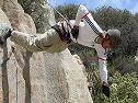
Or you can take it up a notch to Class 3 as Dave did
Image

Whitney, Langley and Olancha Peak from the summit of Owens
Image

The striking rock formation with me atop
Image

Down the scree run
Image

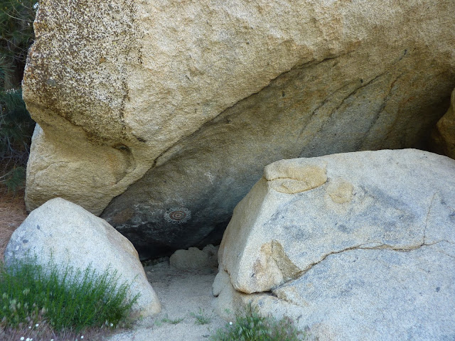
The Indian Pictograph site
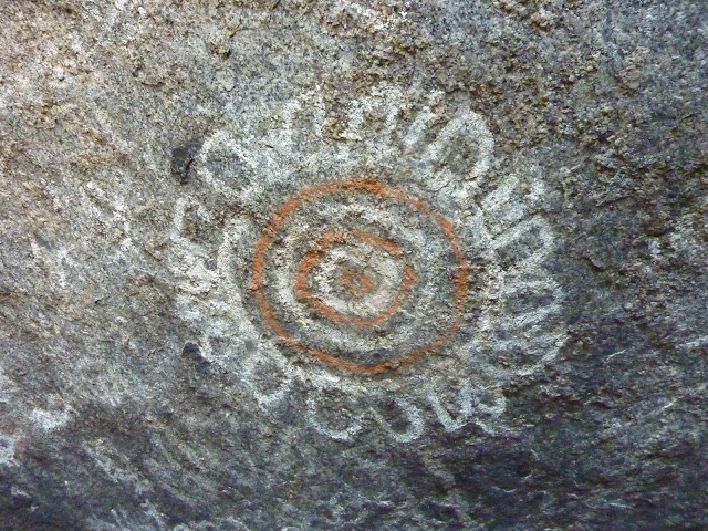
Image

Sunflower
Image

Sheep
Image

Mortero
Image

all of my pix are here:
http://picasaweb.google.com/ryan.norma81/OwensPeak52110#
User avatar
Sam Page
Posts: 267
Joined: Fri Sep 04, 2009 10:59 am

Post by Sam Page »

Cool. I like your photo of Whitney, Langley, and Olancha. On clear days, you get the same view from the summit of Baldy, except the Sierras are much further away.
User avatar
Terry Morse
Posts: 126
Joined: Mon Mar 03, 2008 8:55 pm

Post by Terry Morse »

Love your pics. Cori was going to show me the secret trail & the pictographs this spring, but we never got around to planning it.
User avatar
Dave G
Posts: 321
Joined: Sun Jun 22, 2008 9:51 am

Post by Dave G »

Terry Morse wrote:Love your pics. Cori was going to show me the secret trail & the pictographs this spring, but we never got around to planning it.
Yes, Cori is somewhat of an expert on this area. I recall her telling me about a plane wreck and a second picto site nearby as well.
Fun hike! My pix are here: http://www.flickr.com/photos/21042415@N ... 145000976/
User avatar
Phil B
Posts: 101
Joined: Wed Oct 03, 2007 12:47 pm

Post by Phil B »

Nice pics Norma and Dave, I had seen photos of the pictographs before but did not connect them with Owens Peak, will definitely look out for them next time I'm there. I have to agree with you that those Peaks (Owens, Morris, Jenkins) make great excursions when your between other hikes, there is something very serene and relaxing about that area.

Cheers,

Phil
User avatar
He219
Posts: 386
Joined: Thu Sep 27, 2007 11:18 pm

Post by He219 »

Nice job, guys! Lookin' good :D
User avatar
Kevin
Posts: 23
Joined: Sun Mar 23, 2008 7:22 pm

Post by Kevin »

Nice pics, Norma and Dave, but then I'm a bit biased - I oriented my house so that I would see Owens over the top on my computer monitor - it's about 7 miles away.

I did an interesting "exploratory" hike in IWV Canyon on Monday. Parked about a mile south of the Magnolia Mine and headed up a ridge leading to Russell. My real goal was to explore a valley which runs east/west about 2 miles just south of Morris which I did on the return. The north side of the canyon is a substantial pinion pine forest (at least by high desert standards) and the water table in the canyon floor isn't too far below the surface, so in spots there's lots of grapevines and other vegetation. Lots of wildlife (deer and birds) too.

Last time I was on Owens was 3/31, also with a Dave. This one was a B. not a G... We also took the same downroute you guys took, but to us locals it's called the "Rockwell Shortcut".

Kevin
User avatar
Dave G
Posts: 321
Joined: Sun Jun 22, 2008 9:51 am

Post by Dave G »

Hi Kevin. I've been hearing about Owens for years, but had never got around to climbing it. I found it to be a very picturesque area--much less "deserty" than I had expected. The only other peaks I've done in the Southern Sierra are Spanish Needle and Lamont. Still need Morris, Jenkins and the Five Fingers. Oh, I did do Chuckwalla and Cross last year.

Your Indian Wells Cyn route sounds interesting 8) .

Another "Rockwell Shortcut"? I think he's got enough to fill a book now :) .
Post Reply