
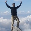
At the last minute Tom and I decided to hike some of the northern peaks of the San Gabriel Mnts, Old Mount Emma, Mount Emma, Cole Point and Mount Gleason. As I am working on completing all of the Sierra Club Hundred Peak Section Peaks of the San Gabriel Mountains, these were included in the last 10 peaks I needed to climb.
We left one car along Angeles Forest Highway at mile marker 6.88. Then we drive the other down Mount Emma Road to a 4x4 road for Old Mount Emma. We parked and hiked up to Old Mount Emma, on to Mount Emma, then lost some serious elevation, up and down many bumps and up to Cole Point. Old Emma and Emma were very barren. But as we approached Cole Point there were a lot more trees and the area a lot more sceneic. We headed down a ridge back to the car, following many cairns along the way. Total was 8 miles and 4500 ft elevation gain. A lot more elevation gain than I figured, it was a real roller coaster hike for Cole Point.
Here is my GPS track, elevation profile and Google Map for these peaks.
It was only 11 am, so we figured we would climb Mount Gleason also. Drove up just past the Prison camp and hooked up with the PCT. Hiked a little past the mountain then caught the road to the summit. Was not 100% sure where the actual peak was, but did find a summit register at one location. We looked from some Nukes, then followed the road down, then hooked up with a ridge to cut off some switchbacks and back to the car. A nice alternative to driving all the way to the locked gate.
Here is my GPS track, elevation profile and Google Map for the Mount Gleason hike.
Old Mount Emma, Mount Emma, Cole Point and Mount Gleason

Congratulations Travis, that's quite a feat.
The Nike-Hercules Surface to Air missile defense consisted of towed lauchers, part of the Greater Los Angeles Air Defense network in the 60's.
Fort Mc Arthur in San Pedro has the best preserved launching areas.
Any remaining visible evidence of the network of other sites around Los Angeles would included roads, prepared launching pads, the occasional radar pedestal, lots of anchor bolts, guard shacks and sometimes the remains of hemispherical corrugated Quonsets buildings.
I remember seeing these hiking up to the Nike site in the hills above Brea as a kid.
Other sites in the local mountains listed here.
Edit: I just read the Nike-Hercules did have the capability for a nuclear warhead in the SAM role.

I remember going up in the mountains back in the 60's when those sites were still active. Kind of a trip to be up there in the "middle of no where" and come across a military installation.
A lot of the "Prison Camps" and maintenance camps are really just the quarters from days of the Nike batteries.
I also remember reading about the "Lulu," a nuclear depth charge, and the "Davy Crocket," a jeep mounted mortar with nuclear capability. Sure is nice to give a 19 year old private first class a weapon with nuclear capability.
Hi Travis,
Thanks for the report. These peaks are also on my list and you've inspired me to get out there this weekend. I'm unfamiliar with the area so I find myself making some assumptions - which can be foolish. The great thing about this board is I can ask advice or someone who's been there! So, when you say you parked one car at mile marker 6.88, I assume this does not correspond to distance from Angeles Crest, correct? Also, you mention driving "to" a 4x4 road, I assume this is where you parked and that you did not have to drive on a 4x4 road? Thanks in advance for setting me straight and for any additional info!
Leslie
No problem. Glad to help. The mile markers are actually descending as you turn left onto Angles Forest Highway (AFH) off of the Angeles Crest Highway (ACH). I think it is close to 15 miles along AFH. You park RIGHT AT the mile marker 6.88. There is a small 4x4 road here that hooks up to the ridge to Cole Point. I did not note the mile marker for our trailhead. You continue down AFH a few miles and turn right on Mount Emma Road. Drive about 5 miles to a prominent ridge and a large dirt road with a yellow gate. If you go to my website you can look at it in Google Earth and download the GPS track. If you have a GPS you can just keep an eye on the GPS and easily locate the trailhead. Total mileage from La Canada for this trailhead was 35.7 miles I believe. We drove a short distance up the road to a clearing and parked. Not necessary but just to get us off the road. There are 3 ridges coming off of Cole Point and it can be confusing if you don’t have the GPS track, in fact, I even got on the wrong ridge with the track. But once you find it, it is marked with ducks most of the way down. I can export a detailed TOPO map tonight if you want, if you don;t have GPS.Leslie L wrote:Hi Travis,
Thanks for the report. These peaks are also on my list and you've inspired me to get out there this weekend. I'm unfamiliar with the area so I find myself making some assumptions - which can be foolish. The great thing about this board is I can ask advice or someone who's been there! So, when you say you parked one car at mile marker 6.88, I assume this does not correspond to distance from Angeles Crest, correct? Also, you mention driving "to" a 4x4 road, I assume this is where you parked and that you did not have to drive on a 4x4 road? Thanks in advance for setting me straight and for any additional info!
Leslie
Thanks for the response! Unfortunately I do not have GPS (yet) and my tom harrison doesn't help much. A TOPO would be great. What if I began the hike at mile marker 6.88, attaining Cole first, then on to the Emmas? Would route finding be easier? How does that affect the elevation gain?
Leslie
Leslie
As you can see in the elevation profile, you will start 285' higher at mile marker 6.88, therefore have a little less gain. Route finding should be a little easier, you would follow the small road around the bump the take the ridge up and stay on the ridge to the high point (see map).Leslie L wrote:Thanks for the response! Unfortunately I do not have GPS (yet) and my tom harrison doesn't help much. A TOPO would be great. What if I began the hike at mile marker 6.88, attaining Cole first, then on to the Emmas? Would route finding be easier? How does that affect the elevation gain?
Leslie
Here is a link to the topo map showing my route,
http://www.class3hiking.com/mount_emma_area.jpg
Did this hike on Sunday starting with Cole Point, on to Mt Emma and ending with Old Mt Emma. There was a kind of beauty in the barren rolling mountaintops and even the burned area drew me in. But boy the ups and downs on this hike will break your heart! I think the mental toll was worse than the physical. A few surprises:
* Seeing OHV’s on the trail – first time for me
* Hunters – we saw about 10 of them and hoped they saw us too
* Beer cans and a half smoked joint in one of the summit register cans
* Sadly, tons of trash on this trail – more than I’ve seen on any other (and not just near the trailheads)
An unusual day in paradise. Thanks, Travis, for the inspiration.
Leslie
that is strange, we did not see any OHV's, hunters, beer cans or joints. Plus I didn't see any more garbage than usual (except at the parking area for old mount emma), I wonder if the hunters (since it is Hunting Season) are bringing in some of this trash? Not that I have anything against hunters, don't want to start anything....
Hey Travis,
If it wasn't for the fact that I used your trip report as my guide, I'd think we were on different hikes!
I don't have anything against hunters either; my hiking partner is an avid hunter. But you might be right. Some of the trash was in piles, suggesting someone spent some time in one spot. We also saw plenty of spent rounds and empty ammo boxes.
Leslie
I wish this wasn't true.Leslie L wrote:Hey Travis,
If it wasn't for the fact that I used your trip report as my guide, I'd think we were on different hikes!
I don't have anything against hunters either; my hiking partner is an avid hunter. But you might be right. Some of the trash was in piles, suggesting someone spent some time in one spot. We also saw plenty of spent rounds and empty ammo boxes.
Leslie
I wish more folks would take LNT ethics to heart.

That looks like a 600 yard shooting range at 34°26'11.46"N 118° 4'15.94"W. It would be a little scary walking the ridge above that range.
tik tik tik . . .
Just looked it up, looks like it's the Desert Marksmen Rifle & Pistol Club. Never heard of it. Nice range, apparently.
tik tik tik . . .
Just looked it up, looks like it's the Desert Marksmen Rifle & Pistol Club. Never heard of it. Nice range, apparently.
Nunc est bibendum
It's not too bad a range, form the drive past at least. Went there a couple times as a kid.
I go to Stockton area in winter and spring, and haven't had any issues. Closer to Chalk Peak is where one would be in possible theoretical danger from fliers.
I go to Stockton area in winter and spring, and haven't had any issues. Closer to Chalk Peak is where one would be in possible theoretical danger from fliers.