Page 1 of 1
Sand Fire - Wildlife Waystation needs help!
Posted: Fri Jul 22, 2016 8:47 pm
by Tom Kenney
http://inciweb.nwcg.gov/incident/4878/
Inciweb does not have a recent update. By 7:30 PM it had crested Magic Mountain. I had plans to go for a ride up there tomorrow AM...guess that's nixed.

See pics below:

Shot from Mulholland btw Sepulveda and Havenhurst (
Full size)

Shot from same as above (
Full size)

Shot from White Oak and LA River (
Full size)
EDIT: Updated title.
Also, current boundary shows fire has crossed Yerba Buena Ridge at Gold Creek Saddle in the southeast, almost to Quail Spring/Indian Canyon in the northeast. Pacoima Reservoir and Kagel Mountain area already engulfed in southwest.
Sky is VERY dark here in Northridge. Starting to get a splitting headache, and I've only been outside for a total of 3 minutes to run garbage to the bin.
Re: Sand Fire - Wildlife Waystation needs help!
Posted: Fri Jul 22, 2016 11:05 pm
by Hikin_Jim
Ugh.
Re: Sand Fire - Wildlife Waystation needs help!
Posted: Sat Jul 23, 2016 1:50 pm
by Tom Kenney
GEOMAC map:
http://www.geomac.gov/viewer/viewer.shtml
Select Data Layers->Active Fires->MODIS Fire Detection to see current boundary.
Looks like it has consumed the remaining oak/pine forest on north side of Mendenhall Ridge west of Iron Mountain. I'm a bit shocked at the size of this. It got a bit windy last night, which didn't help.
Re: Sand Fire - Wildlife Waystation needs help!
Posted: Sat Jul 23, 2016 2:02 pm
by Tom Kenney
Re: Sand Fire - Wildlife Waystation needs help!
Posted: Mon Jul 25, 2016 11:55 am
by AW~
SandFire vs Station Fire

Re: Sand Fire - Wildlife Waystation needs help!
Posted: Mon Jul 25, 2016 10:26 pm
by Sean
NASA has a high resolution
satellite image of the Sand Fire...
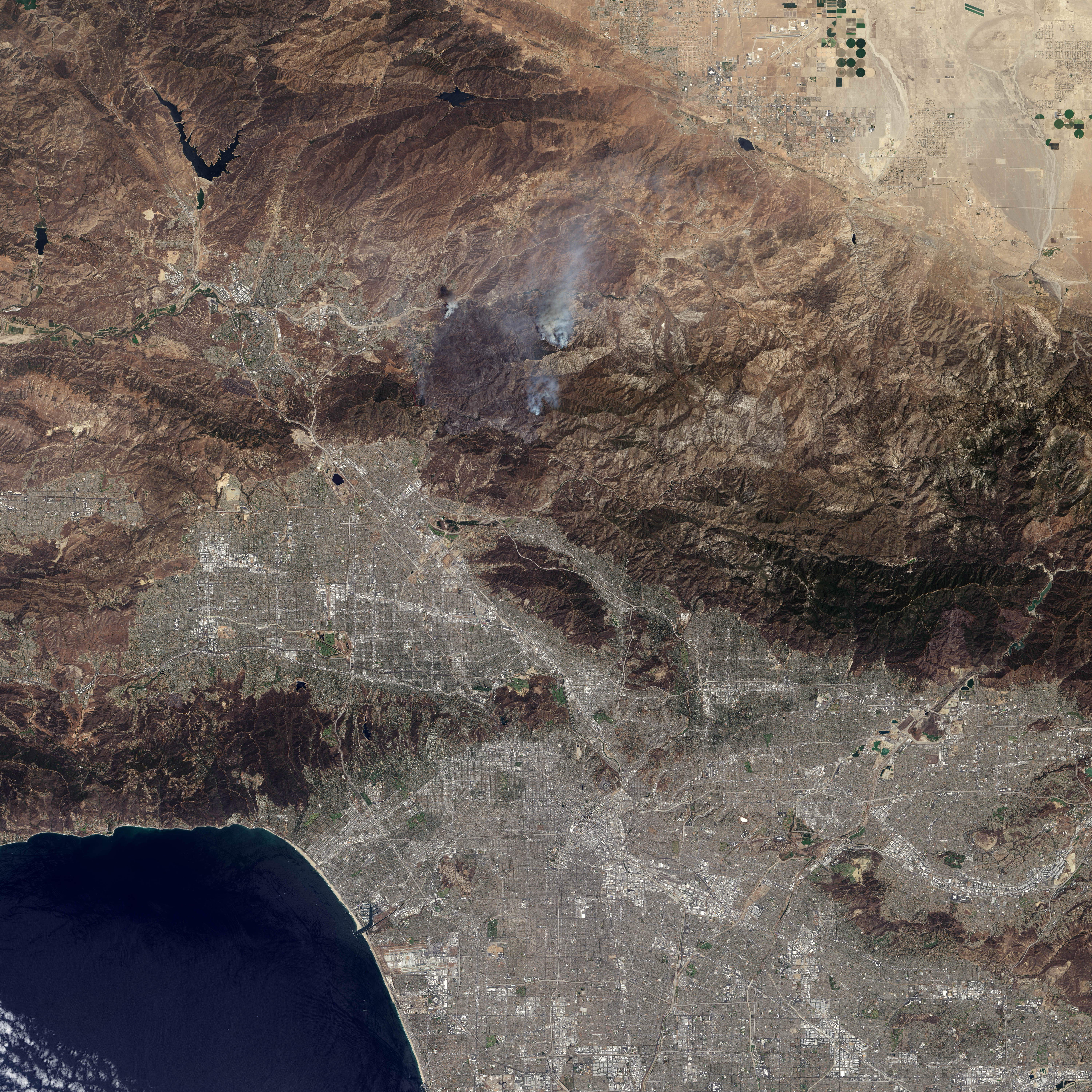
Re: Sand Fire - Wildlife Waystation needs help!
Posted: Tue Jul 26, 2016 12:32 am
by Tom Kenney
Amazing image...thanks. Looks like fire retardant on the west edge, near those neighborhoods.
Re: Sand Fire - Wildlife Waystation needs help!
Posted: Tue Jul 26, 2016 6:53 am
by Uncle Rico
Wow. Very cool image Sean.
I hope that amazing oak grove at Los Pinetos just below the Wilson Saddle doesn't burn.

From this image, it looks like it's still there.
Re: Sand Fire - Wildlife Waystation needs help!
Posted: Tue Jul 26, 2016 11:37 am
by AW~
You wont see that image on the land grabber's thats for sure.
They will keep up fantasy stock footage aka the permanent forest.
Gotta keep up the 'open borders' business here.
Another national burn area equals all the 'modern hikers' and their global warming parade moving on.
Re: Sand Fire - Wildlife Waystation needs help!
Posted: Tue Jul 26, 2016 10:05 pm
by HikeUp
I think I see that dime I dropped and lost on the sidewalk in front of the Gordon Biersch in Burbank.
Road trip!
Re: Sand Fire - Wildlife Waystation needs help!
Posted: Tue Jul 26, 2016 10:08 pm
by HikeUp
AW wrote: You wont see that image on the land grabber's thats for sure.
They will keep up fantasy stock footage aka the permanent forest.
Gotta keep up the 'open borders' business here.
Another national burn area equals all the '
modern hikers' and their global warming parade moving on.
What you got against Casey? LOL
Re: Sand Fire - Wildlife Waystation needs help!
Posted: Wed Jul 27, 2016 12:52 pm
by AW~
HikeUp wrote:
What you got against Casey? LOL
Its against the dictates....that the SG's are just another city park playground that the govt will be a domestic servant to. All bad press will be blamed on global warming and no minimum responsibility to adapt is necessary.Virtual reality will be for those who remember something different.