Page 1 of 1
My First GPS Hike
Posted: Sat Jan 04, 2014 9:54 pm
by Hikin_Jim
I got a GPS for Christmas and went on
my first hike with a GPS on Jan. 1.
Thank you to everyone who gave me input.
OBSERVATIONS
1. There does seem to be a loss of detail (and therefore an under-reporting of mileage) in the process of saving a track. At the end of my hike, my "odometer" read 6.28 miles. When I uploaded to my computer, my mileage read 5.94 miles. That's a loss of about 1/3 miles, which to me is fairly significant, particularly since it was only a 6 mile hike. It looks like I'm losing about 0.05 miles per mile recorded
just due to the way the track is saved alone.
2. If you look at the plot of my route on a satellite photo (see above link), you can see that the GPS basically draws a straight line from when ever it marks a point. Trails are seldom straight lines. I think it's safe to assume that a GPS will always
under report.
3. Give #1 and #2, above, it would seem that GPS unit reported mileages are going to be significantly lower than actual mileages. How much? I'm not sure, but perhaps 0.1 mile lost for every actual mile. The shape of the trail and general topography as well as things like how many GPS/Glonass satellites were in "view" would affect this.
4. If one were to go to the above link and toggle the view to topo map, one would see that the route of things like the Gabrieleno National Recreation Trail shown on the map is quite a bit different than what my GPS plot reveals. While topo maps in the US are generally pretty good, there are a lot of errors.
5. If one looks closely at the satellite photo, one can see some of the road or trail that I was travelling on. The GPS doesn't follow exactly. Sometimes it is in error off to one side; sometimes the other. Clearly, GPS, at least when used in the form of a hand held unit like mine, is an approximation.
GENERAL REMARKS
The Garmin eTrex 20 interface is pretty quick and easy to learn albeit primitive compared to my Samsung Smart Phone. The GPS is interesting, and I look forward to using it more.
Overall, a fun hike. It was even more fun because I had such a good hiking partner.

HJ
Re: My First GPS Hike
Posted: Sun Jan 05, 2014 8:27 am
by Sean
You can improve the accuracy of the track by reducing the time interval between points. Then, afterward, edit the track to remove wonky points and straighten/smooth out lines.
The trip odometer and track log distances are different because they record at different time intervals. The small discrepancies add up, especially if you're traveling through an area with poor GPS reception.
Re: My First GPS Hike
Posted: Sun Jan 05, 2014 12:53 pm
by tekewin
Thanks for the analysis, HJ. I've wondered why the trip odometer is always longer than the track reported mileage. Even though the tracks do wander, they are usually close enough to be useful for back tracking or planning.
Thanks for the time resolution tip, Sean. I'm going to change mine to try to reduce the mileage errors. I have found the GPS to be useless in some terrain, like steep canyons, or anywhere sat lock is lost. I have had to edit tracks that sometimes recorded random points that threw off the whole track, drawing a straight line a full mile away from my actual location. It is a pain sometimes to locate and remove the error point(s).
FYI, I use gpsvisualizer.com to generate profiles and google earth files. Is there a more useful site for create output from the tracks?
Re: My First GPS Hike
Posted: Sun Jan 05, 2014 1:33 pm
by RichardK
I always carry a GPS device, but never use it for distance covered. I can get that from the Topo! map software or maps that give trail distances like Tom Harrison maps. I use GPS to know exactly where I am and what distance and bearing to my objective. My old Garmin 12XL has a moving arrow that directs you to a waypoint. On our recent Furnace Slot Canyon hike, I entered the waypoint for the canyon mouth and let the GPS walk me to the spot. On the return, I let it walk me back to the car. These were no great feats of land navigation, but were great practice for times when conditions might be more difficult. Of course, all of this depends on having a reasonable clear view of the sky. All satellite devices (GPS, SPOT, PLB) share this requirement.
Re: My First GPS Hike
Posted: Sun Jan 05, 2014 3:36 pm
by Hikin_Jim
tekewin wrote: Thanks for the analysis, HJ. I've wondered why the trip odometer is always longer than the track reported mileage. Even though the tracks do wander, they are usually close enough to be useful for back tracking or planning.
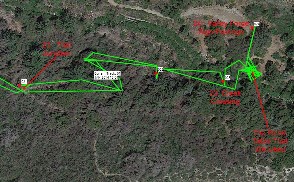
Discrepancies bug me, but let's keep things in perspective. Take a look at the below photo. Waypoint 21 is the trail junction to turn off to Valley Forge Camp. You can see the actual junction in the satellite photo. The discrepancy? A foot or two at the most. Waypoint 23 is the creek crossing near camp. Looks pretty dead on. Waypoint 24 is the main sign for the camp, the one with the rules & regs posted on it. I can't quite see the sign in the Sat photo, but I know it's at the head of the parking lot (which I can see). The waypoint is either dead on or very, very close.
tekewin wrote: FYI, I use gpsvisualizer.com to generate profiles and google earth files. Is there a more useful site for create output from the tracks?
Yeah, I have to play with it using other software. I've heard of GPS Visualizer and Garmin Connect, and I've used CalTopo which has the advantage of having the high resolution USFS maps. What other sites or software are good?
Regarding Settings:
On my eTrex 20, I saw a "recommended default" and then another setting for every 30 seconds. I used the recommended setting on the trip down and the 30 second setting on the way back up. I'll have to dig into the XML to see if I can see any meaningful difference.
I split the legs of the trip and put them on a
new map. Orange=Out and Blue=Back. I can't see any consistent difference in accuracy -- at least as displayed in CalTopo. I haven't tried any analysis of the underlying XML itself (GPS tracks are stored as XML underneath the covers).
HJ
Re: My First GPS Hike
Posted: Sun Jan 05, 2014 3:44 pm
by Hikin_Jim
Sean wrote: The trip odometer and track log distances are different because they record at different time intervals.
Well, if there were two different sampling routines going on, then you'd expect that sometimes the odometer would be greater and that other times the track would be greater. But that's not the case. The odometer is always greater. What this tells me is that somehow in the process of saving the track some degree of accuracy is lost.
HJ
Re: My First GPS Hike
Posted: Sun Jan 05, 2014 4:13 pm
by Sean
Hikin_Jim wrote: The odometer is always greater. What this tells me is that somehow in the process of saving the track some degree of accuracy is lost.
I'm fairly certain that the track is not generated from odometer readings, which are not saved. So there is no degree of accuracy lost. What's happening is that the odometer takes a reading about every second and tacks on whatever distance you've traveled, whereas the track logs points at predetermined time intervals (or distances), then when you save the track it calculates the distance based on the points saved, not the odometer readings.
If you're logging points only every 30 seconds, then your track will be way off. I log every 10 seconds, sometimes less.
Re: My First GPS Hike
Posted: Sun Jan 05, 2014 4:38 pm
by Hikin_Jim
That's really counterintuitive. One would think that a GPS would gather a single set of data points and then compute both the odometer and track from that single data set.
Do you have any documentation on this?
HJ
Re: My First GPS Hike
Posted: Sun Jan 05, 2014 5:22 pm
by Sean
It only "gathers" data points if you turn on the track feature. Otherwise it uses spot readings to calculate distance, time, and elevation. It doesn't have enough memory to record every reading it will ever take in a master log.
So, yes, it gathers/records only one set of data--if you tell it to. But the odometer runs whether you gather the data or not. If you were to set the time interval on your track to one second, you might see the track distance match the odometer.
Garmin Forum
Re: My First GPS Hike
Posted: Sun Jan 05, 2014 5:30 pm
by HikeUp
Risking bringing up some bad memories, here are a couple of GPS discussions from about 5 years ago...
https://eispiraten.com/a ... hlight=gps
https://eispiraten.com/a ... hlight=gps
These had been preceded by some moronic discussions narrated by FIGHT ON, which I didn't bother looking for. Brrrrr
Re: My First GPS Hike
Posted: Sun Jan 05, 2014 5:50 pm
by HikeUp
I also recommend that you do a little experiment. Turn on your GPS and make sure it is locked in to some satellites. Set it down and come back an hour later and see how far it has travelled!
Re: My First GPS Hike
Posted: Sun Jan 05, 2014 5:58 pm
by HikeUp
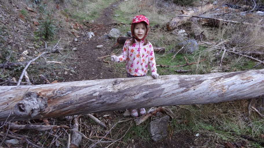
BTW...I think the little one in the non-standard hiking outfit is pointing to her right - best you follow her advice.
Re: My First GPS Hike
Posted: Mon Jan 06, 2014 11:33 pm
by Hikin_Jim
Thank you for those. Memories from those discussions have actually been helpful.
On other fronts, I've now set my sampling interval to 5 seconds (from 30). That ought to get fairly accurate tracks.
I've been playing with a freeware program called GPS Babel which is supposed to convert things like Google Earth KML to Garmin GPX format. Haven't been able to get it to work yet. Anyone got a good KML converter? I've got some Google Earth stuff I'd like to load to my Garmin or to CalTopo. CalTopo just freezes when I try to import KML but does fine with GPX.
HJ
Re: My First GPS Hike
Posted: Tue Jan 07, 2014 5:43 am
by tekewin
HJ,
This might do the conversion for you. I ran a quick test and it looked OK, but I didn't spend much time trying to verify it.
http://www.gpsvisualizer.com/convert_input
Set output type to GPX and upload the KML(Z).
Here is another site to try if that one doesn't work:
http://kml2gpx.com/
Re: My First GPS Hike
Posted: Tue Jan 07, 2014 7:21 am
by Hikin_Jim
Excellent. Thank you. I'll check it out when I get time.
On other fronts, I had heard Garmin's older product, Mapsource was actually simpler to use than their current software, Basecamp. Mapsource appeared to no longer be available on Garmin.com, so I tried to get Mapsource from download.cnet.com. I've used Cnet.com dozens and dozens of times. Never had a problem. I got a boatload of malware this time. I'm now scrubbing my computer. I'll report the problem to Cnet.com when I have time. I hope they haven't become corrupt. I'll post more later.
For now: Beware of cnet.com.
HJ
Re: My First GPS Hike
Posted: Tue Jan 07, 2014 7:37 pm
by yobtaf
yes I needed a copy of synergy for a new computer at work, thing came up to download so I clicked it and got what you are talking about. Had to scroll down farther on the page to get what I needed. cnet has changed a lot.
Re: My First GPS Hike
Posted: Thu Jan 09, 2014 6:24 am
by hvydrt
Caltopo is the cause of the straight lines on the track, not the gps data. Open the track in mapsource or basecamp, that will show you each and every point that your gps recorded. Caltopo has a limit of 2000 points per "shape" So if its a 5000 point track it will adjust the points to 2000.
Changing the recording interval will increase acuracy, but my guess is that your gps is recording just fine and caltopo is the problem.
gps babel is good. I used it a lot to convert .tpo files (the hps map files) to .gpx
Re: My First GPS Hike
Posted: Thu Jan 09, 2014 9:26 am
by Ze Hiker
Yeah, 5 second sampling is still going to miss some small movements that the 1 second sampling will capture, which will add up over the hike. That doesn't mean the 1 second data unfiltered is more "correct", however.
The best estimate will be for you to collect data at the highest sampling frequency (probably 1 Hz) and smooth it yourself and visually looking at your raw and smooth tracks and determining which smooth factor / filter cutoff looks the best.
Re: My First GPS Hike
Posted: Thu Jan 09, 2014 6:37 pm
by everyday
huh, mine always tracks EXACTLY where i was. never in strait lines. it just follows where i went. ive never seen the strait line problem. i hav the garmin foretrex 401
see
http://connect.garmin.com/dashboard