Page 1 of 1
Los Pinos Peak Trail
Posted: Wed Nov 27, 2013 9:33 pm
by scottawr
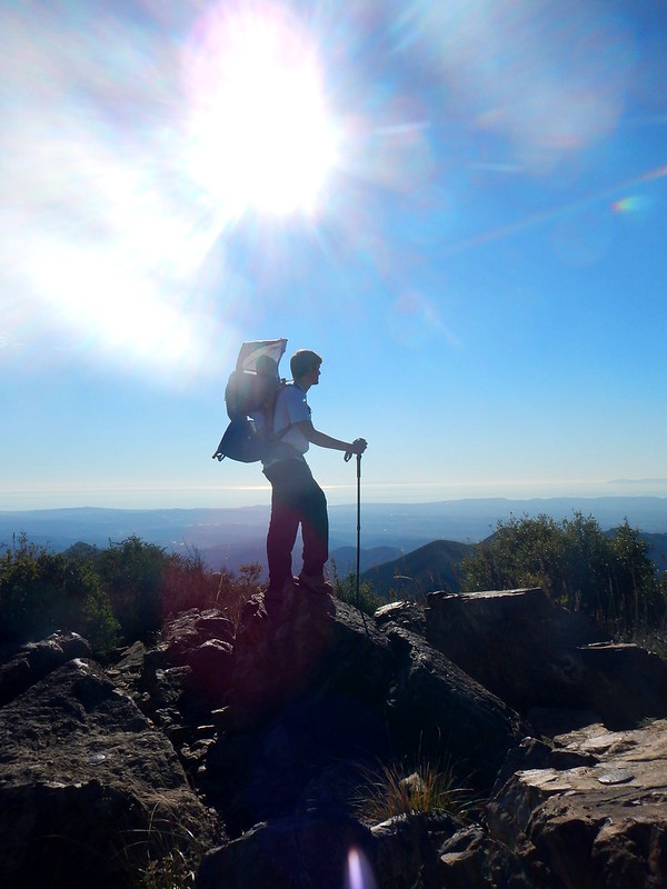
Walked up the Main divide Road From the small parking area near the long canyon road gate up to the Los Pinos peak trail. Its about 5miles and 1000ft the trail is mostly on the ridge line and has great views of Santiago the tallest peak in the Santa Ana's of all of southern California, especially on a clear day like 11/27. Clear views of San Gorgonio, Jacinto, and Antonio even down to San Diego the Palomar observatory and Toro peak were visible. Probably one of the few places you can see all the county high points from one spot. nice sunset over the pacific ocean and mild temperatures perfect winter day in southern California.
Pictures -
http://www.flickr.com/photos/98779591@N ... 134964515/
Re: Los Pinos Peak Trail
Posted: Thu Nov 28, 2013 8:54 am
by Hikin_Jim
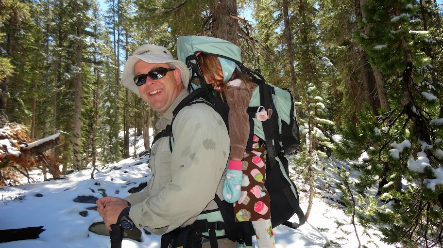
Cute kiddo. Encouraging for me of course.


Awesome.
Nice to know it's not
all chaparral.
Thanks for the TR,
HJ
Re: Los Pinos Peak Trail
Posted: Thu Nov 28, 2013 11:22 am
by scottawr
Hikin_Jim wrote: Cute kiddo. Encouraging for me of course.
thanks! Its always nice having a hiking partner, too bad they don't come in Ultralight.
Re: Los Pinos Peak Trail
Posted: Thu Nov 28, 2013 1:37 pm
by Hikin_Jim
scottawr wrote: Hikin_Jim wrote: Cute kiddo. Encouraging for me of course.
thanks! Its always nice having a hiking partner, too bad they don't come in Ultralight.
The real problem is that they keep getting older... and so do I.

HJ
Re: Los Pinos Peak Trail
Posted: Fri Nov 29, 2013 9:45 pm
by arocknoid
Great photos and family time, Scott.
This one is a classic for the family album review during high school:

Thanks for the TR.
kind regards,
Arocknoid
Re: Los Pinos Peak Trail
Posted: Fri Nov 29, 2013 11:38 pm
by scottawr
arocknoid wrote: Great photos and family time, Scott.
thanks! was a nice relaxing pre-turkey day hike with the family.
Re: Los Pinos Peak Trail
Posted: Sat Nov 30, 2013 7:33 am
by tekewin
Nice report and photos, Scott.
Santiago looks very different from Los Pinos than from any other spot.
Re: Los Pinos Peak Trail
Posted: Sat Nov 30, 2013 1:51 pm
by scottawr
tekewin wrote:
Santiago looks very different from Los Pinos than from any other spot.
Definitely, I love looking at the falls canyon and holy Jim canyons.
I also took at 20,657 x 1738 panorama from the top. Its REALLY big!
http://i.imgur.com/RPuofUf.jpg
Re: Los Pinos Peak Trail
Posted: Sat Nov 30, 2013 2:37 pm
by tekewin
Awesome pano! You (and others) carry nice cameras. I just carry my lousy phone, which is better than nothing I guess.
Re: Los Pinos Peak Trail
Posted: Sat Dec 21, 2013 10:36 pm
by JayO
Los Pinos is a beautiful ridge hike when taken from the bottom - start at the San Juan trail parking area just off the Ortega Hwy, then head out the road to the Lazy W & veer left. 8+ miles of up, up & up.
Re: Los Pinos Peak Trail
Posted: Sun Dec 22, 2013 1:16 am
by scottawr
I've never done Los Pinos from Lazy W. Mostly because its so long and the days get so hot in the Santa Anas, and that I've already hiked so much of that area I always talk myself out long day there.
Re: Los Pinos Peak Trail
Posted: Sun Dec 22, 2013 3:20 pm
by JayO
Try this loop - from the bottom, go up Los Pinos ridge to the summit. Then continue over to Main Divide & head down toward Blue Jay campground. Take the Falcon trail, it is a pretty little shortcut, then continue down the San Juan trail to Cocktail Rock. Take a picture, have a drink, then finish up the last 6.5 miles to the car. Overall about 20 miles.
Re: Los Pinos Peak Trail
Posted: Sun Dec 22, 2013 3:31 pm
by Hikin_Jim
JayO wrote: Overall about
20 miles.
Ouch.
HJ
Re: Los Pinos Peak Trail
Posted: Sun Dec 22, 2013 8:40 pm
by scottawr
definitely sounds like a killer day, which rock is cocktail rock? I have been on the san juan trail a few times and sat on plenty of rocks never knew one was named.
Re: Los Pinos Peak Trail
Posted: Tue Dec 24, 2013 7:02 am
by JayO
Cocktail rock is adjacent to Sugarloaf - just where the New San Juan trail & Old San juan trails converge. Quite a view of the OC from there.
Re: Los Pinos Peak Trail
Posted: Tue Dec 24, 2013 8:34 am
by atomicoyote
You can also do Los Pinos Peak from Trabuco Canyon. The end of the canyon turns into the Trabuco trail, follow it up until the split and take the right trail (NOT the West Horsetheif Trail), and that'll get you to the saddle with the teal posts shown in scottawr's photos. From there its about a 1 mile trailwalk up to the peak. Total round-trip is probably 9 miles.
Re: Los Pinos Peak Trail
Posted: Wed Dec 25, 2013 2:56 am
by scottawr
ooo I did that hike recently
Trabuco canyon to the alleged teal posts
http://www.flickr.com/photos/98779591@N ... 896831145/
Re: Los Pinos Peak Trail
Posted: Wed Dec 25, 2013 10:04 am
by Hikin_Jim
Alleged?
HJ
Re: Los Pinos Peak Trail
Posted: Thu Dec 26, 2013 12:48 am
by scottawr
I meant "aforementioned".
Forgive me, during the holidays I have been spending a lot of time with my attorney sister and her Lawyer fiance. Parts of dinner have sounded like a courtroom discussion, a lot of big words have been thrown around the last week.