Page 1 of 1
Mount Baden-Powell, Burnham, Throop Peak and Lewis
Posted: Mon Dec 24, 2007 8:28 am
by Travis
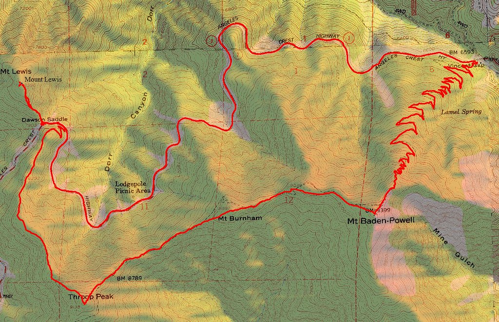
Tom and I went on a beautiful hike yesterday (12-23-07). We hiked up from Vincent Gap to Baden-Powell. The snow was not deep until the drifts near the top. It took us 2.5 hours to reach Baden in the snow. From there, we traversed the ridges to Burnham and then Throop. THe ridge traverse was fun, deep snow in places but you could drop to the south side of the ridge and there was no snow. From Throop we followed the northwest ridge to the Angeles Crest Highway. This was my favorite, the snow was just the right depth the plunge step down, very beautiful. Once we hit the ACH we climbed the ridge to Mount Lewis as well. The views were amazing, you could see the Santa Cruz islands and even ships in the water. The best I have ever seen. From there we hiked back to the ACH for a 5 mile trek along the ACH back to Vincent Gap. We saw some major repairs underway along the road, hopefully they will open it 2008.
http://www.gpsmountaineering.com/mountb ... mountlewis
Re: Mount Baden-Powell, Burnham, Throop Peak and Lewis
Posted: Mon Dec 24, 2007 11:15 am
by simonov
You are hard core, that deep snow just slows me down. I didn't hit much snow yesterday on the Three Tees, luckily.
I have never seen it so clear! My view from the mountain tops was obscured by trees as I was never above the treeline, but driving home through Chino I couldn't believe how clear and close seemed Santiago, San Jacinto, San Gorgonio and of course the San Gabriels. I will never laugh at Chino again, I hadn't realized they had such awesome views.
Re: Mount Baden-Powell, Burnham, Throop Peak and Lewis
Posted: Mon Dec 24, 2007 3:00 pm
by EManBevHills
Looks like you had yerself quite a nice loop trip.

Happy holidays! Thanks for all your work on the site.....
Re: Mount Baden-Powell, Burnham, Throop Peak and Lewis
Posted: Mon Dec 24, 2007 3:33 pm
by Rob
Travis, I couldn't open your Baden-Powell KMZ file -- Google Earth gave me an error message. I'll try again later.
Re: Mount Baden-Powell, Burnham, Throop Peak and Lewis
Posted: Mon Dec 24, 2007 4:02 pm
by Travis
Rob wrote:Travis, I couldn't open your Baden-Powell KMZ file -- Google Earth gave me an error message. I'll try again later.
I just tried myself and it worked fine. Maybe try saving to your computer first, then open in Google Earth from your computer.
Re: Mount Baden-Powell, Burnham, Throop Peak and Lewis
Posted: Mon Dec 24, 2007 4:35 pm
by Rob
Travis, thanks for testing the KMZ file. It works OK for me now. I resolved my Google Earth error message by installing the latest Google Earth update, purging Google Earth "My Places," and restarting the application.
Re: Mount Baden-Powell, Burnham, Throop Peak and Lewis
Posted: Mon Dec 24, 2007 4:42 pm
by Taco
I still have to head up this area. Really cool pictures as well, thanks for taking those shots from ACH!
Re: Mount Baden-Powell, Burnham, Throop Peak and Lewis
Posted: Mon Dec 24, 2007 4:50 pm
by Travis
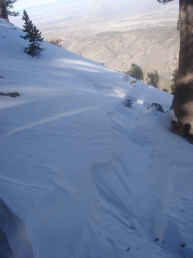
our route up to Baden-Powell involved following some snowborder tracks most of the way. The conditions were perfect, especially near the top. Lots of deep powder, it looks so awesome to snow board down. Take a look at this pic, showing the route through fresh powder that the snow boarder "carved".
Makes me want to take up snowboarding.
Re: Mount Baden-Powell, Burnham, Throop Peak and Lewis
Posted: Mon Dec 24, 2007 4:55 pm
by Taco
That's probably the best way to deal with deep powder. *curses postholing*
Re: Mount Baden-Powell, Burnham, Throop Peak and Lewis
Posted: Mon Dec 24, 2007 7:09 pm
by He219
Nice TR Travis. I'm envious having missed last weekend.
Looks like the snow had just enough of a crust to board, just watch out for submerged hazards.
Definately the way to exfil.

Re: Mount Baden-Powell, Burnham, Throop Peak and Lewis
Posted: Tue Dec 25, 2007 1:49 pm
by Kit Fox
That is quite the accomplishment.
I hiked from Vincent Gap to Throop Peak, then returned on a slightly different route. I imagine "walking along the highway is a bit easier than staying above 8500 feet half the trip.

Re: Mount Baden-Powell, Burnham, Throop Peak and Lewis
Posted: Tue Dec 25, 2007 10:01 pm
by Travis
Yes, there is more mileage following the ACH, but once from Dawson Saddle it is down hill all the way, a lot less elevation gain.
I have been forgetting to download Geocaches to my GPS lately, usually I will check out any caches along the route. I see you do the same.
Re: Mount Baden-Powell, Burnham, Throop Peak and Lewis
Posted: Wed Dec 26, 2007 7:09 am
by Kit Fox
I use Geocaching as "yet another reason" to climb the mountains. All three points referenced on my map have geocaches. Missing from that map was the cache on Baden-Powell and on Ross Mountain.
The number was my geocache find number.
Re: Mount Baden-Powell, Burnham, Throop Peak and Lewis
Posted: Wed Dec 26, 2007 11:26 am
by KathyW
Nice report Travis - Thanks for sharing the report, maps, and pictures. The last section along the ridge to Baden-Powell is so beautiful with snow on it.