Page 1 of 1
San Bernardino Peak from Angeles Oaks TH 2009/07/2
Posted: Fri Jul 03, 2009 10:43 am
by mattmaxon
I made it to the trailhead about 7:15am and was off by 7:20am, the weather was relatively cool and the wind was nice
I made good time as the trail is pretty good and it's not super steep, @ 3.4 miles I stopped for a break and cached some Gatorade for the return trip
@ 4.0 miles 2hrs I came to the junction with Columbine Sprg Tr and an undocumented trail from John's Meadow
As I was photographing the sign a hiker was coming up this trail. He said he was coming from Forsee Trailhead and was making a loop out of the day's hike, sounds like a future trip to me!
3hrs 10min 5.67 miles I came to trailside Limber Pine Spring, it was flowing nicely, I cached my water filter and some other things and pressed on.
I met another hiker coming down who lives in Angeles Oaks, we may meet up soon for a canyon or two...
At 6.92 miles 4hrs 6min I passed by the spur trail to Washington's Monument vowing to stop here for lunch
Moving on I was hoping to see a use trail to the summit but one didn't seem to be there??? I left the trail @ 7.48 miles 4hrs 26min and made the summit @ 7.56 miles 4hrs 30min. I stayed just long enough to sign the register and grab a way point
There was a use trail on the summit, so I followed it back... It brought me to the trail about 10-15 yds from where I'd left the trail DOH!

I stopped at washington's monument for lunch and averaged my waypoint the entire time I was there the GPS indicated a 5ft accuracy after about 40min of averaging.
I passed 3 groups of backpackers on the way back all below the Columbine junction, ugh pumping up that grade in the heat was taking it's toll
My photos such as they are are here
http://picasaweb.google.com/mattmaxon20 ... 009_07_02#
I made it back to the trailhead at 3:38pm for a total of 8hrs and 15min 16miles-ish
Cheers
Matt
Re: San Bernardino Peak from Angeles Oaks TH 2009/07/2
Posted: Fri Jul 03, 2009 11:12 am
by Socalhiker
Thanks for the TR and the pics.
Re: San Bernardino Peak from Angeles Oaks TH 2009/07/2
Posted: Fri Jul 03, 2009 12:47 pm
by Ze Hiker
5ft accuracy eh? is that a consumer grade gps?
Re: San Bernardino Peak from Angeles Oaks TH 2009/07/2
Posted: Fri Jul 03, 2009 2:04 pm
by mattmaxon
Zé wrote:5ft accuracy eh? is that a consumer grade gps?
Si
Re: San Bernardino Peak from Angeles Oaks TH 2009/07/2
Posted: Fri Jul 03, 2009 6:34 pm
by AlanK
Averaging is powerful!

Re: San Bernardino Peak from Angeles Oaks TH 2009/07/2
Posted: Fri Jul 03, 2009 8:21 pm
by Ze Hiker
which model?
i have a garmin 60csx that i've seen as low as 8, sampled every second... just curious.
Re: San Bernardino Peak from Angeles Oaks TH 2009/07/2
Posted: Fri Jul 03, 2009 8:27 pm
by Ze Hiker
AlanK wrote:Averaging is powerful!
yeah but can't beat a wheel!

Re: San Bernardino Peak from Angeles Oaks TH 2009/07/2
Posted: Fri Jul 03, 2009 8:49 pm
by AlanK
Zé wrote:AlanK wrote:Averaging is powerful!
yeah but can't beat a wheel!
It is true that I see as many measuring wheels out on the trails as I ever did. They certainly aren't losing popularity.
Re: San Bernardino Peak from Angeles Oaks TH 2009/07/2
Posted: Fri Jul 03, 2009 10:08 pm
by Rob
mattmaxon wrote:@ 4.0 miles 2hrs I came to the junction with Columbine Sprg Tr and an undocumented trail from John's Meadow
As I was photographing the sign a hiker was coming up this trail. He said he was coming from Forsee Trailhead and was making a loop out of the day's hike, sounds like a future trip to me!
Matt, a couple of years ago, I hiked that loop unintentionally because I had a navigation "oops" at the trail sign you photographed. As I recall, on the day of my hike, the post was there but the signs were missing. The silver lining: I discovered John's Meadow.
. . . Rob

Re: San Bernardino Peak from Angeles Oaks TH 2009/07/2
Posted: Sat Jul 04, 2009 5:44 am
by mattmaxon
Zé wrote:which model?
i have a garmin 60csx that i've seen as low as 8, sampled every second... just curious.
I'm using the GPSmap76CSX, it is the same as the 60csx, or at least the software is
My unit has a waypoint averaging feature which when activated samples the location every X seconds until you hit OK I recall 1200, to 1300 samples when at Washington's Monument
Zé wrote:yeah but can't beat a wheel!
Granted the wheel is more reliable, but the GPS in the shirt pocket is way more convenient
AlanK wrote:It is true that I see as many measuring wheels out on the trails as I ever did. They certainly aren't losing popularity.
Yeah they're common as "Hens teeth"

I don't recall ever seeing one in use, except by me.
Rob wrote:Matt, a couple of years ago, I hiked that loop unintentionally
Rob, they way I look at those events is I wanted to go that way I just didn't know it
Sounds like you had a grand serendipity that day
For me it's not about the destination for the most part but the journey
The one thing I found odd was everyone waiting for the heat of the day to start up WTF? Some of those kids looked really unhappy, "green around the gills" and all that.
It's supposed to be an enjoyable adventure to encourage a future, hopefully life long interest in the outdoors, making them haul big packs up a mountain in 85° temps with the sun directly overhead aint gonna encourage anyone IMO. Except to take up watching "Fishing" on TV

Re: San Bernardino Peak from Angeles Oaks TH 2009/07/2
Posted: Sat Jul 04, 2009 11:55 am
by Hikin_Jim
mattmaxon wrote:@ 4.0 miles 2hrs I came to the junction with Columbine Sprg Tr and an undocumented trail from John's Meadow
As I was photographing the sign a hiker was coming up this trail. He said he was coming from Forsee Trailhead and was making a loop out of the day's hike, sounds like a future trip to me!
This line drawing:
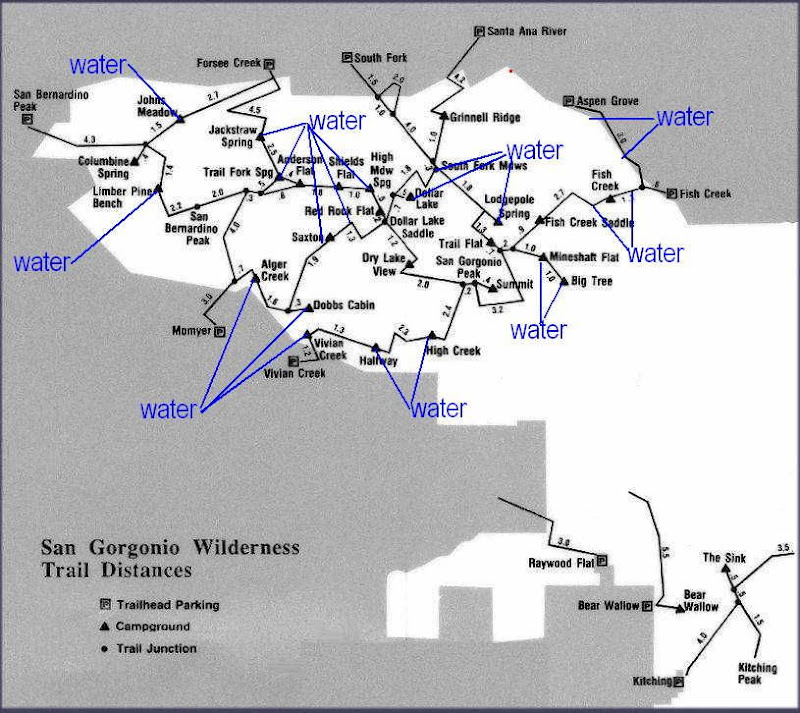
gives a thumbnail sketch of most of the trails in the SGW, including the unmaintained stretch of trail from Johns Meadow to Manzanita Spring (where you took the photo of the trail sign). There are several other abandoned but followable (some only semi-followable) trails* that aren't shown. Some time I'll have to make up a map or something.
HJ
*Abandoned trails of the SGW:
1. Johns Meadow to Manzanita Spring
2. Upper Momyer Creek Trail (section from jct w/ Alger Creek Trail to San Berd. Pk Divide)
4. Lodgepole Spring to Fish Creek Saddle
5. Lodgepole Spring to Lodgepole Saddle (aka Zahniser-Lake Saddle)
6. Old Lower Dollar Lake Trail (very difficult to find)
7. Old Upper Dollar Lake Trail
Other routes of potential interest:
1. Abandoned road from Aspen Grove to Fish Creek Meadows
2. Abandoned road from Heartbar Ranger Station to Fish Creek
3. Abandoned road that connects the above road with Fish Creek Track
4. Fish Creek Track (Hwy 38 to Aspen Grove)
6. "Along the Flume" Track
Re: San Bernardino Peak from Angeles Oaks TH 2009/07/2
Posted: Sat Jul 04, 2009 11:59 am
by Hikin_Jim
Rob wrote:mattmaxon wrote:@ 4.0 miles 2hrs I came to the junction with Columbine Sprg Tr and an undocumented trail from John's Meadow
As I was photographing the sign a hiker was coming up this trail. He said he was coming from Forsee Trailhead and was making a loop out of the day's hike, sounds like a future trip to me!
Matt, a couple of years ago, I hiked that loop unintentionally because I had a navigation "oops" at the trail sign you photographed. As I recall, on the day of my hike, the post was there but the signs were missing. The silver lining: I discovered John's Meadow.
. . . Rob
Rob: Nice to see you post again. Long time no see.
Re: San Bernardino Peak from Angeles Oaks TH 2009/07/2
Posted: Sat Jul 04, 2009 12:34 pm
by Rob
Hikin_Jim wrote:Rob: Nice to see you post again. Long time no see.
HJ, thanks. It's good to be back. I have catching up to do.
. . . Rob